Quemperven
| Quemperven Kemperven | |
|---|---|
| Commune | |
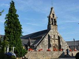 The church of Saint-Hervé | |
 Quemperven Location within Brittany region  Quemperven | |
| Coordinates: 48°43′33″N 3°19′15″W / 48.7258°N 3.3208°WCoordinates: 48°43′33″N 3°19′15″W / 48.7258°N 3.3208°W | |
| Country | France |
| Region | Brittany |
| Department | Côtes-d'Armor |
| Arrondissement | Lannion |
| Canton | Bégard |
| Intercommunality | Centre Trégor |
| Government | |
| • Mayor (2014–2020) | Philippe Weisse |
| Area1 | 7.69 km2 (2.97 sq mi) |
| Population (2008)2 | 383 |
| • Density | 50/km2 (130/sq mi) |
| Time zone | UTC+1 (CET) |
| • Summer (DST) | UTC+2 (CEST) |
| INSEE/Postal code | 22257 /22450 |
| Elevation | 28–93 m (92–305 ft) |
|
1 French Land Register data, which excludes lakes, ponds, glaciers > 1 km2 (0.386 sq mi or 247 acres) and river estuaries. 2 Population without double counting: residents of multiple communes (e.g., students and military personnel) only counted once. | |
Quemperven (Breton: Kemperven) is a commune in the Côtes-d'Armor department of Brittany in northwestern France.
Population
Inhabitants of Quemperven are called quempervennois in French.
Breton language
The municipality launched a linguistic plan through Ya d'ar brezhoneg on July 7, 2006.
See also
References
External links
| Wikimedia Commons has media related to Quemperven. |
- French Ministry of Culture list for Quemperven (in French)
This article is issued from
Wikipedia.
The text is licensed under Creative Commons - Attribution - Sharealike.
Additional terms may apply for the media files.