Saint-Gildas
| Saint-Gildas Sant-Weltaz | |
|---|---|
| Commune | |
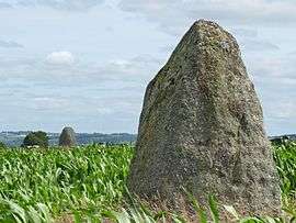 The menhir of Keranhouët, in Saint-Gildas | |
 Saint-Gildas Location within Brittany region  Saint-Gildas | |
| Coordinates: 48°25′23″N 3°00′07″W / 48.4231°N 3.0019°WCoordinates: 48°25′23″N 3°00′07″W / 48.4231°N 3.0019°W | |
| Country | France |
| Region | Brittany |
| Department | Côtes-d'Armor |
| Arrondissement | Saint-Brieuc |
| Canton | Plélo |
| Intercommunality | Pays de Quintin |
| Government | |
| • Mayor (2014–2020) | Annie Simon |
| Area1 | 15.54 km2 (6.00 sq mi) |
| Population (2008)2 | 280 |
| • Density | 18/km2 (47/sq mi) |
| Time zone | UTC+1 (CET) |
| • Summer (DST) | UTC+2 (CEST) |
| INSEE/Postal code | 22291 /22800 |
| Elevation | 195–286 m (640–938 ft) |
|
1 French Land Register data, which excludes lakes, ponds, glaciers > 1 km2 (0.386 sq mi or 247 acres) and river estuaries. 2 Population without double counting: residents of multiple communes (e.g., students and military personnel) only counted once. | |
Saint-Gildas (Breton: Sant-Weltaz) is a commune in the Côtes-d'Armor department of Brittany in northwestern France.
Population
| Historical population | ||
|---|---|---|
| Year | Pop. | ±% |
| 1962 | 435 | — |
| 1968 | 409 | −6.0% |
| 1975 | 351 | −14.2% |
| 1982 | 330 | −6.0% |
| 1990 | 277 | −16.1% |
| 1999 | 257 | −7.2% |
| 2008 | 280 | +8.9% |
Inhabitants of Saint-Gildas are called gildasiens in French.
In legend and fiction
Breton legend connects Gildas with Brittany.[1] The first book by the Irish writer Julia Kavanagh, Saint-Gildas, or, The Three Paths (1847) is largely set in the village in the eighteenth century.
See also
References
- ↑ R. Largilliere, La Topographie du culte de Saint Gildas
External links
| Wikimedia Commons has media related to Saint-Gildas. |
- French Ministry of Culture list for Saint-Gildas (in French)
| Authority control |
|---|
This article is issued from
Wikipedia.
The text is licensed under Creative Commons - Attribution - Sharealike.
Additional terms may apply for the media files.