Guerlédan
| Guerlédan | |
|---|---|
| Commune | |
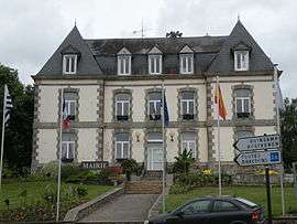 The town hall in Mûr-de-Bretagne | |
 Guerlédan Location within Brittany region  Guerlédan | |
| Coordinates: 48°12′04″N 2°59′06″W / 48.201°N 2.985°WCoordinates: 48°12′04″N 2°59′06″W / 48.201°N 2.985°W | |
| Country | France |
| Region | Brittany |
| Department | Côtes-d'Armor |
| Arrondissement | Saint-Brieuc |
| Canton | Mûr-de-Bretagne |
| Intercommunality | Loudéac Communauté − Bretagne Centre |
| Area1 | 47.75 km2 (18.44 sq mi) |
| Population (2014)2 | 2,501 |
| • Density | 52/km2 (140/sq mi) |
| Time zone | UTC+1 (CET) |
| • Summer (DST) | UTC+2 (CEST) |
| INSEE/Postal code | 22158 /22530 |
|
1 French Land Register data, which excludes lakes, ponds, glaciers > 1 km2 (0.386 sq mi or 247 acres) and river estuaries. 2 Population without double counting: residents of multiple communes (e.g., students and military personnel) only counted once. | |
Guerlédan (Breton: Gwerledan) is a commune in the department of Côtes-d'Armor, western France. The municipality was established on 1 January 2017 by merger of the former communes of Mûr-de-Bretagne (the seat) and Saint-Guen.[1]
See also
References
| Wikimedia Commons has media related to Guerlédan. |
- ↑ Arrêté préfectoral 30 August 2016 (in French)
This article is issued from
Wikipedia.
The text is licensed under Creative Commons - Attribution - Sharealike.
Additional terms may apply for the media files.