Arrondissement of Guingamp
| Guingamp | |
|---|---|
| Arrondissement | |
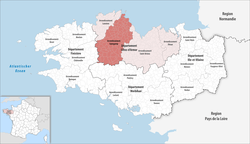 Location of Guingamp in Brittany | |
| Country | France |
| Region | Brittany |
| Department | Côtes-d'Armor |
| Communes | 112 |
| Subprefecture | Guingamp |
| Area¹ | |
| • Total | 2,292 km2 (885 sq mi) |
| Population (2013) | |
| • Total | 126,258 |
| • Density | 55/km2 (140/sq mi) |
| ¹ French Land Register data, which exclude lakes, ponds, and glaciers larger than 1 km² as well as the estuaries of rivers. | |
The arrondissement of Guingamp is an arrondissement of France in the Côtes-d'Armor department in the Brittany region. Since the January 2017 reorganization of the arrondissements of Côtes-d'Armor, it has 112 communes.[1]
Composition
Cantons
The cantons of the arrondissement of Guingamp are:
Communes
The communes of the arrondissement of Guingamp, and their INSEE codes, are:
- Bégard (22004)
- Belle-Isle-en-Terre (22005)
- Bon Repos sur Blavet (22107)
- Boqueho (22011)
- Bourbriac (22013)
- Brélidy (22018)
- Bringolo (22019)
- Bulat-Pestivien (22023)
- Calanhel (22024)
- Callac (22025)
- Canihuel (22029)
- Carnoët (22031)
- La Chapelle-Neuve (22037)
- Châtelaudren (22038)
- Coadout (22040)
- Cohiniac (22045)
- Duault (22052)
- Le Faouët (22057)
- Glomel (22061)
- Gommenec'h (22063)
- Gouarec (22064)
- Goudelin (22065)
- Grâces (22067)
- Guingamp (22070)
- Gurunhuel (22072)
- Kerfot (22086)
- Kergrist-Moëlou (22087)
- Kerien (22088)
- Kermoroc'h (22091)
- Kerpert (22092)
- Landebaëron (22095)
- Lanleff (22108)
- Lanloup (22109)
- Lannebert (22112)
- Lanrivain (22115)
- Lanrodec (22116)
- Lanvollon (22121)
- Lescouët-Gouarec (22124)
- Locarn (22128)
- Loc-Envel (22129)
- Lohuec (22132)
- Louargat (22135)
- Maël-Carhaix (22137)
- Maël-Pestivien (22138)
- Magoar (22139)
- Mellionnec (22146)
- Le Merzer (22150)
- Moustéru (22156)
- Le Moustoir (22157)
- Pabu (22161)
- Paimpol (22162)
- Paule (22163)
- Pédernec (22164)
- Peumerit-Quintin (22169)
- Pléguien (22177)
- Pléhédel (22178)
- Plélauff (22181)
- Plélo (22182)
- Plerneuf (22188)
- Plésidy (22189)
- Plévin (22202)
- Ploëzal (22204)
- Plouagat (22206)
- Ploubazlanec (22210)
- Plouëc-du-Trieux (22212)
- Plouézec (22214)
- Plougonver (22216)
- Plouguernével (22220)
- Plouha (22222)
- Plouisy (22223)
- Ploumagoar (22225)
- Plounévez-Quintin (22229)
- Plourac'h (22231)
- Plourivo (22233)
- Plouvara (22234)
- Pludual (22236)
- Plusquellec (22243)
- Pommerit-le-Vicomte (22248)
- Pont-Melvez (22249)
- Pontrieux (22250)
- Quemper-Guézennec (22256)
- Rostrenen (22266)
- Runan (22269)
- Saint-Adrien (22271)
- Saint-Agathon (22272)
- Saint-Clet (22283)
- Saint-Connan (22284)
- Sainte-Tréphine (22331)
- Saint-Fiacre (22289)
- Saint-Gilles-les-Bois (22293)
- Saint-Gilles-Pligeaux (22294)
- Saint-Igeaux (22334)
- Saint-Jean-Kerdaniel (22304)
- Saint-Laurent (22310)
- Saint-Nicodème (22320)
- Saint-Nicolas-du-Pélem (22321)
- Saint-Péver (22322)
- Saint-Servais (22328)
- Senven-Léhart (22335)
- Squiffiec (22338)
- Trébrivan (22344)
- Treffrin (22351)
- Tréglamus (22354)
- Trégomeur (22356)
- Trégonneau (22358)
- Tréguidel (22361)
- Trémargat (22365)
- Tréméven (22370)
- Tréogan (22373)
- Tressignaux (22375)
- Trévérec (22378)
- Yvias (22390)
References
- ↑ "Arrêté préfectoral, 8 December 2016, p 7" (PDF). Retrieved 2017-07-31.
External links
This article is issued from
Wikipedia.
The text is licensed under Creative Commons - Attribution - Sharealike.
Additional terms may apply for the media files.