Troguéry
| Troguéry Trogeri | |
|---|---|
| Commune | |
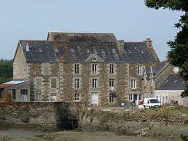 The mill in Troguéry | |
 Troguéry Location within Brittany region  Troguéry | |
| Coordinates: 48°45′17″N 3°13′28″W / 48.7547°N 3.2244°WCoordinates: 48°45′17″N 3°13′28″W / 48.7547°N 3.2244°W | |
| Country | France |
| Region | Brittany |
| Department | Côtes-d'Armor |
| Arrondissement | Lannion |
| Canton | Tréguier |
| Intercommunality | Pays Rochois |
| Government | |
| • Mayor (2014–2020) | Serge Henry |
| Area1 | 3.61 km2 (1.39 sq mi) |
| Population (2008)2 | 284 |
| • Density | 79/km2 (200/sq mi) |
| Time zone | UTC+1 (CET) |
| • Summer (DST) | UTC+2 (CEST) |
| INSEE/Postal code | 22383 /22450 |
| Elevation | 0–55 m (0–180 ft) |
|
1 French Land Register data, which excludes lakes, ponds, glaciers > 1 km2 (0.386 sq mi or 247 acres) and river estuaries. 2 Population without double counting: residents of multiple communes (e.g., students and military personnel) only counted once. | |
Troguéry (Breton: Trogeri) is a commune in the Côtes-d'Armor department of Brittany in northwestern France.
Population
| Historical population | ||
|---|---|---|
| Year | Pop. | ±% |
| 1962 | 274 | — |
| 1968 | 290 | +5.8% |
| 1975 | 238 | −17.9% |
| 1982 | 227 | −4.6% |
| 1990 | 224 | −1.3% |
| 1999 | 233 | +4.0% |
| 2008 | 284 | +21.9% |
People from Troguéry are known in French as troguérois.
See also
References
External links
| Wikimedia Commons has media related to Troguéry. |
- French Ministry of Culture list for Troguéry (in French)
This article is issued from
Wikipedia.
The text is licensed under Creative Commons - Attribution - Sharealike.
Additional terms may apply for the media files.