Plouha
| Plouha Plouha | ||
|---|---|---|
| Commune | ||
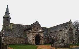 Kermaria an'Iskuit Chapel | ||
| ||
 Plouha Location within Brittany region  Plouha | ||
| Coordinates: 48°41′N 2°56′W / 48.68°N 2.93°WCoordinates: 48°41′N 2°56′W / 48.68°N 2.93°W | ||
| Country | France | |
| Region | Brittany | |
| Department | Côtes-d'Armor | |
| Arrondissement | Guingamp | |
| Canton | Plouha | |
| Intercommunality | Lanvollon Plouha | |
| Government | ||
| • Mayor (2016–2020) | Philippe Delsol | |
| Area1 | 39.97 km2 (15.43 sq mi) | |
| Population (2015)2 | 4,476 | |
| • Density | 110/km2 (290/sq mi) | |
| Time zone | UTC+1 (CET) | |
| • Summer (DST) | UTC+2 (CEST) | |
| INSEE/Postal code | 22222 /22580 | |
| Elevation | 0–109 m (0–358 ft) | |
|
1 French Land Register data, which excludes lakes, ponds, glaciers > 1 km2 (0.386 sq mi or 247 acres) and river estuaries. 2 Population without double counting: residents of multiple communes (e.g., students and military personnel) only counted once. | ||
.svg.png)
Plouha (Breton: Plouha, Gallo: Plóha) is a commune in the Côtes-d'Armor department of Brittany in northwestern France.
Population
| Historical population | ||
|---|---|---|
| Year | Pop. | ±% |
| 1962 | 4,227 | — |
| 1968 | 4,296 | +1.6% |
| 1975 | 4,195 | −2.4% |
| 1982 | 4,248 | +1.3% |
| 1990 | 4,197 | −1.2% |
| 1999 | 4,397 | +4.8% |
| 2004 | 4,425 | +0.6% |
| 2009 | 4,582 | +3.5% |
| 2014 | 4,464 | −2.6% |
| 2015 | 4,476 | +0.3% |
Inhabitants of Plouha are called plouhatins in French.
Twin towns
Plouha is twinned with:


History
Plouha has many notable medieval sites ranging from chapels and churches to manoires and kers. The Chapel of Kermaria (Kermaria an Iskuit) is perhaps the most widely recognized outside of Brittany.
World War II
Plouha's beaches were the sight of several Resistance efforts, notably as part of the Comet line, a resistance group that sheltered Allied troops and helped them return to Great Britain. The plage Bonaparte in Plouha was the site for the Shelburne Operation which organized the return of Allied airmen to Dartmouth, UK.
See also
References
External links
| Wikimedia Commons has media related to Plouha. |
- Official website (in French)
- French Ministry of Culture list for Plouha (in French)