Pommeret
| Pommeret Peuñvrid | |
|---|---|
| Commune | |
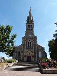 The church of Saint-Pierre, in Pommeret | |
 Pommeret Location within Brittany region  Pommeret | |
| Coordinates: 48°27′48″N 2°37′30″W / 48.4633°N 2.625000°WCoordinates: 48°27′48″N 2°37′30″W / 48.4633°N 2.625000°W | |
| Country | France |
| Region | Brittany |
| Department | Côtes-d'Armor |
| Arrondissement | Saint-Brieuc |
| Canton | Lamballe |
| Intercommunality | Lamballe |
| Government | |
| • Mayor (2014–2020) | Loïc Deron |
| Area1 | 13.35 km2 (5.15 sq mi) |
| Population (2008)2 | 1,852 |
| • Density | 140/km2 (360/sq mi) |
| Time zone | UTC+1 (CET) |
| • Summer (DST) | UTC+2 (CEST) |
| INSEE/Postal code | 22246 /22120 |
| Elevation | 35–80 m (115–262 ft) |
|
1 French Land Register data, which excludes lakes, ponds, glaciers > 1 km2 (0.386 sq mi or 247 acres) and river estuaries. 2 Population without double counting: residents of multiple communes (e.g., students and military personnel) only counted once. | |
Pommeret (Breton: Peuñvrid, Gallo: Pomerèt) is a commune in the Côtes-d'Armor department of Brittany in northwestern France.
Population
Inhabitants of Pommeret are called pommeretois or pommeretin in French.
See also
References
| Wikimedia Commons has media related to Pommeret. |
This article is issued from
Wikipedia.
The text is licensed under Creative Commons - Attribution - Sharealike.
Additional terms may apply for the media files.