Trébeurden
| Trébeurden Trebeurden | ||
|---|---|---|
| Commune | ||
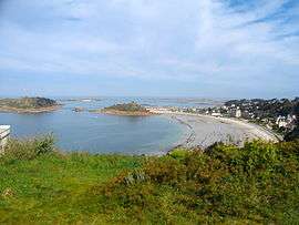 Tresmeur beach, in Trébeurden | ||
| ||
 Trébeurden Location within Brittany region  Trébeurden | ||
| Coordinates: 48°46′13″N 3°34′01″W / 48.7703°N 3.5669°WCoordinates: 48°46′13″N 3°34′01″W / 48.7703°N 3.5669°W | ||
| Country | France | |
| Region | Brittany | |
| Department | Côtes-d'Armor | |
| Arrondissement | Lannion | |
| Canton | Perros-Guirec | |
| Intercommunality | Lannion Trégor | |
| Government | ||
| • Mayor (2014–2020) | Alain Faivre | |
| Area1 | 13.40 km2 (5.17 sq mi) | |
| Population (2008)2 | 3,717 | |
| • Density | 280/km2 (720/sq mi) | |
| Time zone | UTC+1 (CET) | |
| • Summer (DST) | UTC+2 (CEST) | |
| INSEE/Postal code | 22343 /22560 | |
| Elevation | 0–104 m (0–341 ft) | |
|
1 French Land Register data, which excludes lakes, ponds, glaciers > 1 km2 (0.386 sq mi or 247 acres) and river estuaries. 2 Population without double counting: residents of multiple communes (e.g., students and military personnel) only counted once. | ||

Trébeurden (Breton: Trebeurden) is a commune in the Côtes-d'Armor department of Brittany in northwestern France.
Population
Inhabitants of Trébeurden are called trébeurdinais in French.
International relations
Trébeurden is twinned with:


See also
References
- ↑ "Coopération décentralisée : Trebeurden / Vilcelele" (in French). Commission nationale de la coopération décentralisée. Archived from the original on 2013-11-04. Retrieved 2013-11-04.
- ↑ "Coopération décentralisée : Trebeurden / Villanuova Sul Clisi" (in French). Commission nationale de la coopération décentralisée. Archived from the original on 2013-11-04. Retrieved 2013-11-04.
External links
| Wikimedia Commons has media related to Trébeurden. |
- Official website (in French)
- French Ministry of Culture list for Trébeurden (in French)
This article is issued from
Wikipedia.
The text is licensed under Creative Commons - Attribution - Sharealike.
Additional terms may apply for the media files.