Saint-Denoual
| Saint-Denoual Sant-Denwal | |
|---|---|
| Commune | |
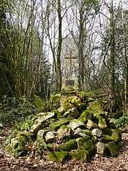 The tomb of the Marquis de la Rouërie | |
 Saint-Denoual Location within Brittany region  Saint-Denoual | |
| Coordinates: 48°31′41″N 2°23′57″W / 48.5281°N 2.3992°WCoordinates: 48°31′41″N 2°23′57″W / 48.5281°N 2.3992°W | |
| Country | France |
| Region | Brittany |
| Department | Côtes-d'Armor |
| Arrondissement | Saint-Brieuc |
| Canton | Pléneuf-Val-André |
| Intercommunality | Pays de Matignon |
| Government | |
| • Mayor (2014–2020) | Marie-Thérèse Salou |
| Area1 | 8.61 km2 (3.32 sq mi) |
| Population (2008)2 | 401 |
| • Density | 47/km2 (120/sq mi) |
| Time zone | UTC+1 (CET) |
| • Summer (DST) | UTC+2 (CEST) |
| INSEE/Postal code | 22286 /22400 |
| Elevation | 44–108 m (144–354 ft) |
|
1 French Land Register data, which excludes lakes, ponds, glaciers > 1 km2 (0.386 sq mi or 247 acres) and river estuaries. 2 Population without double counting: residents of multiple communes (e.g., students and military personnel) only counted once. | |
Saint-Denoual (Breton: Sant-Denwal) is a commune in the Côtes-d'Armor department of Brittany in northwestern France.
Population
| Historical population | ||
|---|---|---|
| Year | Pop. | ±% |
| 1962 | 382 | — |
| 1968 | 369 | −3.4% |
| 1975 | 330 | −10.6% |
| 1982 | 342 | +3.6% |
| 1990 | 362 | +5.8% |
| 1999 | 354 | −2.2% |
| 2008 | 401 | +13.3% |
Inhabitants of Saint-Denoual are called guinguenoualais in French.
See also
References
External links
| Wikimedia Commons has media related to Saint-Denoual. |
This article is issued from
Wikipedia.
The text is licensed under Creative Commons - Attribution - Sharealike.
Additional terms may apply for the media files.