Henderson, Nevada
| Henderson, Nevada | |
|---|---|
| City | |
| City of Henderson | |
 .jpg) 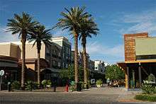    | |
| Motto(s): A Place to Call Home | |
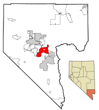 Location of Henderson in Clark County, Nevada | |
 U.S. Census map | |
 Henderson, Nevada Location in the United States | |
| Coordinates: 36°2′N 114°59′W / 36.033°N 114.983°W | |
| Country | United States |
| State | Nevada |
| County | Clark |
| Founded | 1941 |
| Incorporated | April 16, 1953 |
| Named for | Charles Henderson |
| Government | |
| • Type | Council-manager |
| • Mayor | Debra March (D) |
| • Manager | Bob Murnane |
| Area | |
| • Total | 107.7 sq mi (279.0 km2) |
| • Land | 107.7 sq mi (279.0 km2) |
| • Water | 0.0 sq mi (0.0 km2) |
| Elevation | 1,867 ft (538 m) |
| Population (2010) | |
| • Total | 257,729 (US:67th) |
| • Estimate (2017)[1] | 307,928 |
| Time zone | UTC−8 (PST) |
| • Summer (DST) | UTC−7 (PDT) |
| ZIP codes | 89002, 89009, 89011, 89012, 89014-89016, 89044, 89052, 89053, 89074, 89077 |
| Area code(s) | 702 and 725 |
| FIPS code | 32-31900 |
| GNIS feature ID | 0856267 |
| Website |
www |
Henderson, officially the City of Henderson, is a city in Clark County, Nevada, United States, about 16 miles southeast of Las Vegas. It is the second-largest city in Nevada, after Las Vegas, with an estimated population of 307,928 in 2017.[2] The city is part of the Las Vegas metropolitan area, which spans the entire Las Vegas Valley. Henderson occupies the southeastern end of the valley, at an elevation of approximately 1,330 feet (410 m).
History

The township of Henderson first emerged in the 1940s during World War II with the building of the Basic Magnesium Plant. Henderson quickly became a main supplier of magnesium in the United States, which was called the "miracle metal" of World War II.[3] The plant supplied the US War Department with magnesium for incendiary munition casings and airplane engines, frames, and other parts. A quarter of all US wartime magnesium came from the Henderson Plant to strengthen aluminum, using 25% of Hoover Dam's power to separate the metal from its ore by electrolysis.[4] Mayor Jim Gibson's grandfather, Fred D. Gibson, was one of the original engineers sent to Great Britain to learn the secret of creating the "miracle metal" which would eventually help the United States and its allies win the war. The British liaison officer sent to Henderson, Major Charles Ball, had a street named after him. There was some concern that "Ball St," would sound improper, so the street was named "Major Avenue".
Although "born in America's defense", Henderson's future after World War II was uncertain. In 1947, magnesium production was no longer necessary for defense, and the majority of the 14,000 BMI employees moved away. Enrollment in the school system was reduced by two thirds, and well over half the townsite houses, built to house plant workers, became vacant. In 1947, the United States War Asset Administration had offered Henderson for sale as war surplus property.
In an effort to save the city, the Nevada Legislature spent a weekend visiting Henderson, evaluating the possibility of state administration of Basic Magnesium. Within days of the visit, the legislators unanimously approved a bill giving the Colorado River Commission of Nevada the authority to purchase the industrial plants. Governor Vail Pittman signed the bill on March 27, 1947, helping save Henderson from becoming war surplus property.
With the help of local industry, Henderson was incorporated on April 16, 1953 as the City of Henderson. On May 23, 1953, Henderson, with its population of 7,410, elected Dr. Jim French as the first mayor. Originally only about 13 square miles (34 km2) in size, the city quickly began to grow, reaching over 94 square miles (240 km2) in size today.
In 1988, the Pacific Engineering and Production Company of Nevada (PEPCON) rocket fuel factory, in the modern-day Gibson Springs neighborhood of Henderson, caught fire. The blaze quickly spread and engulfed the factory, spewing rocket fuel, smoke, and toxic fumes from the building, eventually obliterating it in a massive explosion, followed by six smaller explosions. These sent shockwaves throughout Henderson and parts of the Las Vegas Valley, shattering glass and damaging buildings. The explosions also caused earthquakes, some of which measured over 3.0 on the Richter magnitude scale. Two people were killed, and an additional 372 injured.
The events of the PEPCON factory disaster spurred development in Henderson years later, from its historical industrial development to residential and commercial development. There are now no signs of the explosion where it happened. Today, the site consists mostly of office buildings.
In February 2018, the Oakland Raiders (who in 2017 announced that they will relocate to Las Vegas in time for the 2020 NFL season) announced the signing of a deal for 55 acres of land near Henderson Executive Airport, on which will be built the team's executive offices and practice facility.[5]
Geography

Henderson is located 16 miles (26 km) southeast of downtown Las Vegas at 36°2′23″N 114°58′52″W / 36.03972°N 114.98111°W (36.03972, -114.98111).[6]
According to the United States Census Bureau, the city has a total area of 107.7 square miles (279.0 km2), all land.[7]
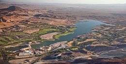
The city is situated in the Mojave Desert with wildlife and vegetation typical of the Mojave. The mountains that surround Henderson mostly have gentle slopes. The McCullough Range is closest to the city; most of this range is covered by black rocks from a volcanic explosion millions of years ago. These mountains reach an average height of about 3,800 feet (1,200 m). The landscape consists of desert; the only water in the city is found in washes like Duck Creek.
Residential neighborhoods in Henderson include Anthem, Anthem Country Club, Ascaya, Black Mountain Vistas, Cadence, Calico Ridge, Champion Village, The Fountains, Grand Legacy, Green Valley, Green Valley Estates, Green Valley Ranch, Hillsboro Heights, Inspirada, Lake Las Vegas, MacDonald Highlands, MacDonald Ranch, Madeira Canyon, Club at Madeira Canyon, Roma Hills, Seven Hills, Sun City Anthem, Sun City MacDonald Ranch, Tuscany Residential Village, and Whitney Ranch.
Climate
Henderson is classified as having a hot desert climate (BWh) in the Köppen climate classification. It has mild winters and hot summers. Snow can occasionally fall in the winter. The monsoon can bring storms in the summer, which can cause flash flooding and thunderstorms. The hottest month is July and the coldest month is December.
| Climate data for Henderson, Nevada | |||||||||||||
|---|---|---|---|---|---|---|---|---|---|---|---|---|---|
| Month | Jan | Feb | Mar | Apr | May | Jun | Jul | Aug | Sep | Oct | Nov | Dec | Year |
| Record high °F (°C) | 75 (24) |
86 (30) |
91 (33) |
97 (36) |
111 (44) |
114 (46) |
117 (47) |
112 (44) |
110 (43) |
100 (38) |
90 (32) |
78 (26) |
117 (47) |
| Average high °F (°C) | 54 (12) |
59 (15) |
67 (19) |
75 (24) |
85 (29) |
95 (35) |
101 (38) |
99 (37) |
91 (33) |
78 (26) |
64 (18) |
54 (12) |
77 (25) |
| Average low °F (°C) | 41 (5) |
44 (7) |
49 (9) |
56 (13) |
65 (18) |
74 (23) |
79 (26) |
78 (26) |
71 (22) |
60 (16) |
48 (9) |
40 (4) |
59 (15) |
| Record low °F (°C) | 11 (−12) |
12 (−11) |
25 (−4) |
31 (−1) |
37 (3) |
41 (5) |
56 (13) |
59 (15) |
43 (6) |
30 (−1) |
4 (−16) |
9 (−13) |
4 (−16) |
| Average precipitation inches (mm) | 0.70 (17.8) |
0.96 (24.4) |
0.57 (14.5) |
0.23 (5.8) |
0.11 (2.8) |
0.11 (2.8) |
0.46 (11.7) |
0.72 (18.3) |
0.42 (10.7) |
0.36 (9.1) |
0.49 (12.4) |
0.60 (15.2) |
5.73 (145.5) |
| Source: [8] | |||||||||||||
Demographics
| Historical population | |||
|---|---|---|---|
| Census | Pop. | %± | |
| 1950 | 3,643 | — | |
| 1960 | 12,525 | 243.8% | |
| 1970 | 16,395 | 30.9% | |
| 1980 | 24,363 | 48.6% | |
| 1990 | 64,942 | 166.6% | |
| 2000 | 175,381 | 170.1% | |
| 2010 | 257,729 | 47.0% | |
| Est. 2017 | 307,928 | [1] | 19.5% |
| source:[9][10] | |||
At the census of 2010,[11] there were 257,729 people residing in Henderson. The racial makeup was 76.9% White, 5.1% African American, 0.7% Native American, 7.2% Asian, 0.6% Pacific Islander, and 4.8% from two or more races. Hispanic or Latino of any race were 14.9% of the population and 68.7% of the population was non-Hispanic White.
According to the 2000 census, there were 175,381 people, 66,331 households, and 47,095 families residing in the city. The population density was 2,200.8 people per square mile (849.7/km²). There were 71,149 housing units at an average density of 892.8 per square mile (344.7/km²). The racial makeup of the city was 80.49% White, 3.76% African American, 0.70% Native American, 3.98% Asian, 0.42% Pacific Islander, 3.16% from other races, and 3.49% from two or more races. Hispanic or Latino of any race were 13.71% of the population.
There were 66,331 households out of which 33.0% had children under the age of 18 living with them, 56.4% were married couples living together, 10.0% had a female householder with no husband present, and 29.0% were non-families. 20.3% of all households were made up of individuals and 5.0% had someone living alone who was 65 years of age or older. The average household size was 2.63 and the average family size was 3.05.
In the city, the population was spread out with 25.1% under the age of 18, 7.9% from 18 to 24, 32.5% from 25 to 44, 24.4% from 45 to 64, and 10.1% who were 65 years of age or older. The median age for the city was 36 years. For every 100 females, there were 98.4 males. For every 100 females age 18 and over, there were 96.4 males.
The median income for a household in the city was $63,830, and the median income for a family was $74,120. The per capita income for the city was $33,238. The Henderson zip code 89012 where MacDonald Highlands is located, has the 7th highest per-capita income in the United States at $148,899. About 3.9% of families and 5.6% of the population were below the poverty line, including 6.4% of those under age 18 and 4.7% of those age 65 or over.[12]
Economy
Top employers
According to the city's Comprehensive Annual Financial Report, fiscal year ending June 30, 2016,[13] the top employers in the city are:
| # | Employer | # of Employees |
|---|---|---|
| 1 | City of Henderson | 2,985 |
| 2 | St. Rose Dominican Hospital – Siena Campus | 2,000-2,499 |
| 3 | Green Valley Ranch Resort & Spa | 1,500-1,999 |
| 4 | Sunset Station Hotel & Casino | 1,000-1,499 |
| 5 | M Resort | 1,000-1,499 |
| 6 | Barclay's Services LLC | 800-899 |
| 7 | St. Rose Dominican Hospital – Rose de Lima Campus | 700-799 |
| 8 | Fiesta Henderson Casino Hotel | 600-699 |
| 9 | Titanium Metals Corp. of America | 500-599 |
| 10 | Sunrise Carpentry Inc. | 400-499 |
Culture and entertainment

.jpg)
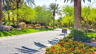
An increasing number of major shopping malls, movie theater complexes, concert venues, restaurants and casino resorts offer residents a variety of choices for leisure time in Henderson. The city also sits a few miles southeast of Las Vegas and is not too far from the world-famous Las Vegas Strip. "Shakespeare in the Park" celebrated its tenth anniversary in 1996, a testament to Henderson's long-standing support for the arts and cultural programs. The city also boasts the largest recreational facility – the Multigenerational Facility at Liberty Pointe – in Nevada as well as Nevada's only scenic Bird Preserve. The city supports a variety of other cultural events as well, many of which are held at the outdoor amphitheater, the largest one of its kind in Nevada.
Film history
- Henderson is frequently featured on the TV drama CSI: Crime Scene Investigation as the location of residence of a victim or other person of interest, although the majority of the show's filming takes place in California.
- The documentary Real CSI featured the Henderson Police Department (HPD) Crime Scene Analysts/Investigators.
- The 1998 film Lethal Weapon 4 used Interstate 215 as a filming location.
- A scene in the James Bond film Diamonds Are Forever in which Bond (Sean Connery) is nearly cremated alive was filmed at Palm Mortuary's Henderson location.[14] Later in the movie, he is dumped into a pipeline, which was filmed near Lake Mead Boulevard. The construction office for the Lake Mead to Las Vegas water pipeline was located there during the building of the pipeline and the filming of the movie.
- America's Sweethearts, starring Julia Roberts and John Cusack, featured many scenes filmed at Lake Las Vegas.[15]
- Paranormal Activity 4 takes place at the home of a wealthy family in Henderson.
Select points of interest
- Acacia Demonstration Gardens
- Anthem Country Club
- Ascaya
- Black Mountain Recreation Center
- Clark County Heritage Museum
- The District at Green Valley Ranch
- Ethel M Botanical Cactus Garden
- Ethel M Chocolate Factory
- Galleria at Sunset
- Green Valley Ranch Resort, Spa, and Casino
- Henderson Bird Viewing Preserve and Water Reclamation Facility
- Henderson International School
- Henderson Pavilion Concert Theater and Recreational Plaza
- Lake Las Vegas
- Lamborghini Las Vegas
- M Resort
- MacDonald Highlands
- Montelago Village and Boutiques
- Nevada State College
- Ravella at Lake Las Vegas
- Rio Secco Golf Club
- Roma Hills
- Seven Hills Estates
- Sunset Station
- Veteran's Wall
- Westin Resort at Lake Las Vegas
- Wildhorse Golf Club[16]
Hiking trails
Henderson has more than 37 miles (60 km) of trails.[17]
Government
The city received its charter from the Nevada State Legislature in 1953, formally incorporating the city with a council/manager form of government.
Henderson is divided into four wards. A mayor and four council members are elected citywide, but no more than one council member are allowed to reside in each ward.
Lorna Kesterson was elected as Henderson's first female mayor, serving two terms until 1993.[18][19]
Fire prevention services are provided by the Henderson Fire Department and police services by the Henderson Police Department.
| Service | Mayor |
|---|---|
| 1953–1957 | James B. French |
| 1957–1965 | William B. Byrne |
| 1965–1969 | William R. Hampton |
| 1969–1973 | Estes M. McDoniel |
| 1973–1975 | Cruz Olague |
| 1975 | Richard A. Stewart, Sr. |
| 1975–1981 | Lorin L. Williams |
| 1981–1985 | Leroy Zike |
| 1985–1993 | Lorna J. Kesterson |
| 1993–1997 | Robert A. Groesbeck |
| 1997–2009 | James B. Gibson |
| 2009– 2017 | Andy A. Hafen |
| 2017–Present | Debra March |
2013 Americans with Disabilities Act settlement
In 2013, the Department of Justice (DOJ) announced that it had reached a cooperative settlement agreement with the city of Henderson under the Americans with Disabilities Act (ADA). The DOJ received complaints by individuals who are deaf that officers for the city of Henderson did not provide them with qualified sign language interpreters and other auxiliary aids and services when needed for effective communication. One of the complainants had been arrested and detained for two days in the Henderson detention facility, while the other was an alleged crime victim.[20]
During the course of its investigation into the allegations, the department inquired whether the city of Henderson would be interested in resolving the matter voluntarily. The city expressed its full commitment to ensure compliance with the ADA. Under the settlement, the city of Henderson will pay a total of $35,000 to the complainants. The city agreed to provide sign language interpreters, usually within an hour of a person's request to law enforcement officers. Henderson also agreed to modify its handcuffing policies for people who use sign language or hand writing to communicate, and to adopt other policies consistent with the ADA.[20]
Education
The Clark County School District provides elementary and secondary public education. Henderson is the location for 29 elementary schools, nine middle schools, and nine high schools. Five of the nine high schools are public schools. The remaining four are private college preparatory schools, including the Henderson International School. A tenth high school, Silverado High School, also serves parts of Henderson but is located in the unincorporated Clark County (Paradise).
Findlay College Prep
Findlay Prep is a high school basketball program sponsored by the Henderson International School. Despite closing its high school in 2010 due to the local economic downturn,[21] Henderson International School - a private preparatory school owned by Meritas (education) - hosts Findlay College Prep. since its creation in 2006 by businessman Cliff Findlay, its dozen students comprise the school's only high school students.[22] Findlay has had several McDonald's All-Americans and alumni playing in the National Basketball Association (NBA).
Colleges and universities
Henderson is home to several colleges and universities. Nevada State College, a baccalaureate college in the Nevada System of Higher Education. The Roseman University of Health Sciences, a private university which awards degrees in nursing, pharmacy, and business, is located in Henderson. The College of Southern Nevada, a community college based in Las Vegas, maintains a branch campus in Henderson. California's National University, Touro University Nevada and Devry University also maintain a campus in Henderson.
Several for-profit colleges also operate in the city, including the International Academy of Design & Technology (Henderson campus closed in 2016), The Art Institute of Las Vegas, and Everest College.
Nevada State College
Founded in 2002 on a 509-acre (2.06 km2) site in the southern foothills of Henderson, Nevada State College offers academic programs regular and accelerated nursing degrees, education degrees, and liberal arts majors including psychology, biology, history, English, criminal justice, and an Occupational Therapy joint degree program in conjunction with Touro College. Its first permanent building, the Liberal Arts and Sciences building, opened in August 2008. Nevada State College's full-time faculty is 34.2% ethnic/racial minorities, which is the highest percentage of all colleges of the Nevada System of Higher Education institutions. The college realized accreditation through the efforts of its late President Dr. Fred Maryanski.
Media
Newspapers
- Las Vegas Review-Journal
- Las Vegas Sun
- Green Valley View
- The Henderson Press
Television
KVVU-TV (channel 5) is the Las Vegas Valley's Fox affiliate and licensed to Henderson, and is based from studios on the northwest side of the city.
Transportation
The city is served by RTC Transit (formerly Citizens Area Transit/CAT) with its network of bus routes which run throughout the Las Vegas Valley.
Henderson is served by four major highways: Henderson Black Hills and (State Route 582), which is the main thoroughfare connecting with Las Vegas and Boulder City; Lake Mead Parkway (State Route 564); Interstate 515 and Interstate 215. State Route 146, also known as Saint Rose Parkway, connects Interstate 15 near Sloan with Interstate 215 in Green Valley. This stretch is formally a part of Lake Mead Parkway which is a direct link to Henderson for motorists traveling in and out of Southern California.
The city of Henderson has a low percentage of households without a car. In 2015, 2.8 percent of Henderson households lacked a car, and increased to 5 percent in 2016. The national average was 8.7 percent in 2016. Henderson averaged 1.74 cars per household in 2016, compared to a national average of 1.8.[23]
Henderson is home for the Henderson Executive Airport. The main airport for the metropolitan area is McCarran International Airport, located northwest of Henderson.
Street numbering is different within the city of Henderson than with the rest of the Las Vegas Valley. The center of Henderson lies within the intersection of Water Street and Lake Mead Parkway. The Henderson Police Department for years referred to Lake Mead Parkway (and its former name Lake Mead Drive) as "146", while Boulder Highway is often referred as "93", its former highway designation.
The Union Pacific Railroad serves Henderson over a branch line originally built to support construction of Hoover Dam. The final few miles of the line, owned by the U.S. Government, were abandoned after the dam was completed. The line still extends to Boulder City; in 1985, the state purchased the section east of appropriately I-515, with the Nevada Southern Railroad Museum operating excursion trains over the easternmost seven miles (11 km).
Rocket fuel factory fire
In 1988, the PEPCON rocket fuel factory became engulfed in fire. Smoke was seen from 100 miles away, and two major blasts measured 3.0 and 3.5, respectively, on the Richter magnitude scale at observatories in California and Colorado.[24] Investigators surveying the damage in the surrounding communities estimated the blast as similar to a 1-kiloton airblast nuclear detonation.[24] Two people were killed. The explosion spurred the development of Henderson from industrial to the largely residential area it is today. There are no signs of the Pepcon explosion today, and the site now consists mostly of office buildings.
Notable people
The following is an incomplete list of notable Henderson residents:
- René Angélil (1942–2016), Canadian musical producer, talent manager and singer
- Steve Aoki (born 1977), electro-house musician, record producer, DJ and music executive[25]
- Erica Blasberg (1984–2010), LPGA golfer[26]
- Toni Braxton (born 1967), singer[27]
- Glen and Les Charles, creators of Cheers and Taxi[28]
- Phyllis Davis (1940–2013), film and television actress
- Hailey Dawson (born 2010), girl with 3D-printed robotic hand
- Celine Dion (born 1968), Canadian pop singer[29]
- Sheena Easton (born 1959), pop singer
- Flavor Flav (born 1959), rap music artist and reality television personality[30]
- Brandon Flowers (born 1981), vocalist for The Killers[31]
- Jeff Gillan (born 1957), journalist
- Bryce Harper (born 1992), professional baseball player
- Greg Haugen (born 1960), three-time world champion boxer[32]
- Iris Kyle (born 1974), professional female bodybuilder
- Pierre Omidyar (born 1967), CEO and founder of eBay[33]
- Jermaine O'Neal (born 1978), NBA player[34]
- Marie Osmond (born 1959), singer, doll designer, and talk show host
- Paul Pierce (born 1977), NBA player[35]
- Harry Reid (born 1939), retired United States Senator
- Nia Sanchez (born 1990), Miss USA 2014
- David Sklansky (born 1947), professional poker player/author[36]
- Mike Tyson (born 1966), retired heavyweight boxer and television personality[37]
- Nancy Walton Laurie (born 1952), daughter of Walmart co-founder James "Bud" Walton[38]
See also
References
- 1 2 "Population and Housing Unit Estimates". Retrieved June 9, 2017.
- ↑ "Annual Estimates of the Resident Population for Incorporated Places: April 1, 2010 to July 1, 2015". Archived from the original on June 2, 2016. Retrieved July 2, 2016.
- ↑ Lelande Quick, Miracle Metal from Nevada Hills, Desert Magazine, June 1944, pages 10-13
- ↑ Moore, David. The Hoover Dam: A World Renowned Concrete Monument Roman Concrete, 1999. Accessed: 26 February 2012.
- ↑ Lopez, Sandy (February 6, 2018). "Henderson finalizes land deal with Raiders". Las Vegas Review-Journal. Retrieved 2018-07-30.
- ↑ "US Gazetteer files: 2010, 2000, and 1990". United States Census Bureau. 2011-02-12. Retrieved 2011-04-23.
- ↑ "Geographic Identifiers: 2010 Demographic Profile Data (G001): Henderson city, Nevada". U.S. Census Bureau, American Factfinder. Retrieved October 15, 2014.
- ↑ "Monthly Averages for Henderson, NV". Weather.com. Retrieved November 21, 2011.
- ↑ Moffatt, Riley. Population History of Western U.S. Cities & Towns, 1850-1990. Lanham: Scarecrow, 1996, 156.
- ↑ "Table 3. Annual Estimates of the Resident Population for Incorporated Places in Nevada: April 1, 2010 to July 1, 2011". census.gov.
- ↑ "Henderson (city) QuickFacts from the US Census Bureau".
- ↑ "Henderson, Nevada Economy". www.bestplaces.net.
- ↑ "City of Henderson Comprehensive Annual Financial Report" (PDF). cityofhenderson.com.
- ↑ Block, Marcelline (2011). World Film Locations: Las Vegas. Intellect Books. Page 16. ISBN 9781841505886.
- ↑ Communications, Emmis (June 2001). Los Angeles Magazine. Emmis Communications.
- ↑ "Wildhorse Golf Golf Course Henderson Las Vegas Golf". Wildhorse Golf.
- ↑ Lyle, Michael (May 15, 2008). "Battle-born Henderson now 'A Place to Call Home'". Las Vegas Sun.
- ↑ McMurdo, Doug (2012-01-17). "Former Henderson mayor Lorna Kesterson dies at 86". Las Vegas Review-Journal. Retrieved 2012-01-20.
- ↑ Zvosec, Carla J. "City's first and only female mayor dies at age 86". Henderson Press. Archived from the original on 2013-01-03.
- 1 2 Department of Justice Office of Public Affairs (5 August 2013). "Justice Department Reaches Settlement with the City of Henderson, Nev. to Improve Law Enforcement Communications with People Who Are Deaf or Hard of Hearing". US Department of Justice. Retrieved 7 August 2013.
- ↑ Green, Steve. "Henderson International School closing all of three campuses.", Las Vegas Sun, 26 February 2010. Retrieved on 24 May 2015.
- ↑ Abramson, Mitch. "Former Knick Jerome Williams coaches Findlay Prep, one of country's top high school basketball teams.", Daily News (New York), 5 October 2013. Retrieved on 24 May 2015.
- ↑ "Car Ownership in U.S. Cities Data and Map". Governing. Retrieved May 4, 2018.
- 1 2 "From Rockets to Ruins: The PEPCON Ammonium Perchlorate Plant Explosion". NASA Safety Center System Failure Case Study. 6 (9). November 2012. Retrieved 7 August 2013.
- ↑ "Chatting up Steve Aoki as he preps to celebrate his birthday at Hakkasan". lasvegasweekly.com.
- ↑ Shipnuck, Alan (December 13, 2010). "The Mystery of Erica Blasberg". Sports Illustrated. Archived from the original on June 6, 2017. Retrieved July 23, 2018.
- ↑ "Toni Braxton's House (former)". Virtual Globetrotting.
- ↑ "Toledo Blade - Google News Archive Search".
- ↑ http://www.celebrityhousepictures.com/celine-dion.php
- ↑ Associated Press (February 8, 2016). "Flavor Flav Pleads No Contest to DUI Charge in Las Vegas". Billboard. Archived from the original on July 23, 2018. Retrieved July 23, 2018.
- ↑ McLean, Craig (2006-09-24). "Songs of praise". The Guardian. London. Retrieved 2010-05-04.
- ↑ Kantowski, Ron (May 16, 2008). "One Tough Guy, Even When He Lost". Las Vegas Sun. Archived from the original on March 8, 2016.
- ↑ "Pierre Omidyar's House". Virtual Globetrotting.
- ↑ "Jermaine O'Neal's House". Virtual Globetrotting.
- ↑ "Paul Pierce's House". Virtual Globetrotting.
- ↑ 72os.com - Poker League, Poker Community - David Sklansky - Player Profile Archived 2007-07-15 at the Wayback Machine.
- ↑ "Mike Tyson spent $2.5M to move down the street". reviewjournal.com. 12 March 2016.
- ↑ "Las Vegas Business Press". Las Vegas Business Press.
External links
- City of Henderson official website
- Henderson District Public Libraries
- Henderson Chamber of Commerce
- Henderson Economic Development Division
- Henderson Cultural Arts & Tourism Department
Coordinates: 36°01′45″N 115°01′31″W / 36.0292°N 115.0253°W
Mayors of cities with populations exceeding 100,000 in Nevada | ||
|---|---|---|
| ||
Municipalities and communities of Clark County, Nevada, United States | ||
|---|---|---|
| Cities | 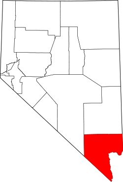 | |
| CDPs | ||
| Unincorporated communities | ||
| Township | ||
| Ghost towns | ||
| Indian reservations | ||
| Footnotes | ‡This populated place also has portions in an adjacent county or counties | |
Carson City (capital) | ||
| Topics |
|  |
| Society | ||
| Regions | ||
| Metro areas | ||
| Counties | ||
| Cities and communities |
| |
| Former counties | ||