Tüp District
| Tüp | |
|---|---|
| Raion | |
| Түп району | |
 | |
| Country | Kyrgyzstan |
| Region | Issyk-Kul Region |
| Area | |
| • Total | 2,121 km2 (819 sq mi) |
| Population (2009) | |
| • Total | 58,786 |
| • Density | 28/km2 (72/sq mi) |
| Time zone | UTC+5 (GMT +5) |
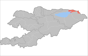
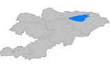
Tüp is a raion (district) of Issyk-Kul Region in north-eastern Kyrgyzstan. The capital lies at Tyup.[1] Its area is 2,121 square kilometres (819 sq mi), and its resident population was 58,786 in 2009.[2] It borders Issyk Kul District to the west, Ak-Suu District to the east and south-east, Kazakhstan to the north, and Issyk Kul to the south.
Populated places
In total, Tüp District includes 37 settlements in 13 rural communities (aiyl okmotus). Each rural community may include one or several villages. The rural communities and settlements in the Tüp District are:[3][4]
- Ak-Bulak aiyl okmotu (1: center - village: Ak-Bulak)
- Aral aiyl okmotu (5: center - village: Ming-Bulak; and also villages Aral, Dolon, Kosh-Debe and Sary-Döbö)
- Issyk-Kel aiyl okmotu (2: center - village: Issyk-Kel; and also village Yntymak)
- Kuturgu aiyl okmotu (4: center - village: Kuturgu, and also villages Kichi-Örüktü, Oy-Bulak and Oy-Tal)
- Mikhaylovka aiyl okmotu (1: center - village: Mikhaylovka)
- Toguz-Bulak aiyl okmotu (2: center - village: Toguz-Bulak; and also village Sary-Bulun)
- San-Tash aiyl okmotu (5: center - village: Bayzak; and also villages Karkyra, Keng-Suu, San-Tash and Sary-Tölögöy)
- Sary-Bulak aiyl okmotu (2: center - village: Balbay; and also village Kürmöntü)
- Ak-Bulun aiyl okmotu (3: center - village: Ak-Bulun; and also villages Belovodskoe and Frunzenskoe)
- Taldy-Suu aiyl okmotu (4: center - village: Taldy-Suu; and also villages Ichke-Suu, Keochu and Korumdu)
- Karasaev aiyl okmotu (3: center - village: Tasma; and also villages Toktoyan and Chong-Toguz-Bay)
- Tüp aiyl okmotu (3: center - village: Tüp; and also villages Birlik and Shaty)
- Chong-Tash aiyl okmotu (2: center - village: Chong-Tash; and also village Jyluu-Bulak)
References
- ↑ Enrin.grida.no
- ↑ "2009 population census of the Kyrgyz Republic: Issyk-Kul Region" (PDF). Archived from the original (PDF) on 10 August 2011. Retrieved 2011-08-10.
- ↑ List of Rural Communities of Kyrgyzstan Archived 2010-02-09 at the Wayback Machine.
- ↑ 2012 Law on the transformation of individual urban settlements of the Kyrgyz Republic and relating them to the category of village or city
| North Krygyzstan |
|  | ||||||||||
|---|---|---|---|---|---|---|---|---|---|---|---|---|
| South Krygyzstan |
| |||||||||||
Coordinates: 42°43′25″N 78°21′41″E / 42.723477°N 78.361330°E
This article is issued from
Wikipedia.
The text is licensed under Creative Commons - Attribution - Sharealike.
Additional terms may apply for the media files.