Kochkor District
| Kochkor | |
|---|---|
| Raion | |
 | |
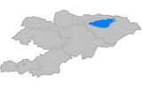
| Country | Kyrgyzstan |
| Region | Naryn Region |
| Area | |
| • Total | 5,868 km2 (2,266 sq mi) |
| Population (2009) | |
| • Total | 58,267 |
| • Density | 9.9/km2 (26/sq mi) |
| Time zone | UTC+5 (GMT +5) |
Kochkor is a raion (district) of Naryn Region in northern-central Kyrgyzstan. The capital lies at Kochkor.[1] Its area is 5,868 square kilometres (2,266 sq mi), and its resident population was 58,267 in 2009.[2]
Populated places
In total, Kochkor District includes 11 settlements in 11 rural communities (aiyl okmotus). Each rural community comprises one or several villages. The rural communities and settlements in the Kochkor District are as follows:[3]
- Ak-Kyya aiyl okmotu (2: center - village: Kara-Suu; and also village Jany-Jol)
- Kara-Suu aiyl okmotu (5: center - village: Mantysh; and also villages Ak-Talaa, Kara-Moynok, Kyzyl-Töbö and Ortok)
- Kochkor aiyl okmotu (3: center - village: Kochkor; and also villages Tendik and Bolshevik)
- Kosh-Debe aiyl okmotu (2: center - village: Kara-Saz; and also village Kara-Küngöy)
- Kum-Döbö aiyl okmotu (4: center - village: Kum-Döbö; and also villages Ak-Jar, Buguchu and Shamshy)
- Sary-Bulak aiyl okmotu (2: center - village: Ak-Kyya; and also village Sary-Bulak)
- Semiz-Bel aiyl okmotu (4: center - village: Kara-Too; and also villages Arsy, Semiz-Bel and Chekilbek)
- Talaa-Bulak aiyl okmotu (2: center - village: Döng-Alysh; and also village Komsomol)
- Kok-Jar aiyl okmotu (1: center - village: Kok-Jar)
- Cholpon aiyl okmotu (5: center - village: Cholpon, and also villages Ara-Köl, Tyuz, Epkin and Osoaviakhim)
- Song-Kul aiyl okmotu (1: center - village: Tölök)
Also Keng-Suu, 6.9km from Sary-Bulak.
References
- ↑ Enrin.grida.no Archived 2009-08-02 at the Wayback Machine.
- ↑ "2009 population census of the Kyrgyz Republic: Naryn Region" (PDF). Archived from the original (PDF) on 25 October 2012. Retrieved 2016-06-15.
- ↑ List of Rural Communities of Kyrgyzstan Archived 2010-02-09 at the Wayback Machine.
| North Krygyzstan |
|  | ||||||||||
|---|---|---|---|---|---|---|---|---|---|---|---|---|
| South Krygyzstan |
| |||||||||||
This article is issued from
Wikipedia.
The text is licensed under Creative Commons - Attribution - Sharealike.
Additional terms may apply for the media files.