Jalal-Abad Region
| Jalal-Abad Region Жалал-Абад областы Джалал-Абадская область | |||
|---|---|---|---|
| Region | |||
 | |||
| |||
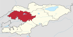 Map of Kyrgyzstan, location of Jalal-Abad Region highlighted | |||
| Coordinates: 41°15′N 72°15′E / 41.250°N 72.250°ECoordinates: 41°15′N 72°15′E / 41.250°N 72.250°E | |||
| Country |
| ||
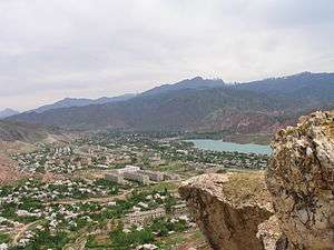
| Capital | Jalal-Abad | ||
| Government | |||
| • Gubernator | Zhusupbek Sharipov | ||
| Area | |||
| • Total | 33,700 km2 (13,000 sq mi) | ||
| Population (2015-01-01)[1] | |||
| • Total | 1,122,400 | ||
| • Density | 33/km2 (86/sq mi) | ||
| Time zone | UTC+6 (East) | ||
| • Summer (DST) | UTC+6 (not observed) | ||
| ISO 3166 code | KG-J | ||
| Districts | 8 | ||
| Cities | 5 | ||
| Townships | 8 | ||
| Villages | 415 | ||

Jalal-Abad Region, also known as Jalalabat (Kyrgyz: Жалалабат облусу, Calalabat oblusu, جالالابات وبلۇسۇ; Uzbek: Jalolobod viloyati, Жалолобод вилояти, جەلالاباد ۋىلايەتى; Russian: Джала́л-Аба́дская о́бласть, Džalál-Abádskaja óblastj), is a region (oblast) of Kyrgyzstan. Its capital is the city of the same name, Jalal-Abad. It is surrounded by (clockwise from the north) Talas Region, Chuy Region, Naryn Region, Osh Region, and Uzbekistan. Jalal-Abad Region was established on 21 November 1939. On 27 January 1959 it became a part of Osh Region, but regained its old status as a region on 14 December 1990. Jalal-Abad Region consist of 8 districts, and includes 5 towns, 8 urba-type settlements, and 415 villages [2]
Geography
Jalalabad oblast covers 33,647 square kilometres (12,991 sq mi) square kilometers (16.9% of total country's area) in central-western Kyrgyzstan.
The southern edge of the region is part of the Ferghana Valley. The rest of the region is mountainous. M41, the main north-south highway from Bishkek to Osh, takes a very crooked route down the center of the region. Another road follows the south border almost to the western tip and then turns northeast up the Chatkal valley to Kyzyl-Adyr in Talas Region. Another road (closed in winter and requiring a jeep from the Ferghana range to Kazarman) goes east to Kazarman and Naryn.
An integral part of the country's power system is Toktogul hydroelectric power station, which supplies electricity and water to both Kyrgyzstan and neighboring countries.
Ecology and Environment
The area has several mountain lakes, walnut forests, and mineral waters. It has also the world's largest natural growing walnut forest, called Arslanbob, about 40 kilometres (25 mi) north of Jalal-Abad city. Jalal-Abad Region is rich in ecological resources. Among strictly protected areas (IUCN Ia Category) located in the region are Sary-Chelek State Biosphere Nature Reserve, Besh-Aral State Nature Reserve, and Padyshata State Nature Reserve. Also there is State Nature National Park Saimaluu-Tash located in Toguz-Toro District. Natural monuments (IUCN category III) include: Tegerek Waterfall located in the upper reaches of Kara-Unkur River, Sogon-Tash Cave, and composed of red sandstone Kara-Jygach Rocks in Aksy District. Among other protected areas are:
- Forest reserves (Kuru-Kol Forest Reserve, Mesken-Say Forest Reserve, Dashman Forest Reserve, Batrakhan Forest Reserve, Uzun Akmat Forest Reserve)
- Botanical reserves (Chanach Botanical Reserve, Kosh-Tekir Botanical Reserve, Chatkal Botanical Reserve, Ryazan-Say Botanical Reserve, Djeltiybes Botanical Reserve)
- Game reserves (Toguz-Toro Game Reserve, Chychkan Game Reserve, Sandalash Game Reserve)
Economy
Basic Socio-Economic Indicators
Economy
Wheat, fruit, vegetables, maize, nuts, tobacco, and silk-worm cocoons are grown in the region. The region also has a few textile plants and hydroelectric stations. Minerals, natural gas, coal, metals, and oil can be found here, notably around the town of Kochkor-Ata, which is home to small scale oil industry. Most of the extraction of minerals, natural gas, coal, metals, and oil of the Soviet era has ceased.

A pearl of the region is the Sary-Chelek Nature Reserve with Lake Sary-Chelek, surrounded by wild fruit orchards and snow-covered peaks.
A few Soviet-era resorts offer mineral water treatment programs for people with various chronic diseases. A number of companies have succeeded in trading bottled mineral water around the country and abroad.
Except for the small fringes of the Fergana Valley, Jalal-Abad Region is a land of mountains. There are unlimited trekking possibilities in the area, but the lack of infrastructure, except at Arslanbob, poses problems to visitors; a biodiversity conservation program supported by the government and the Global Environment Facility (GEF) is working to protect these natural resources and promote soft tourism.
Districts of Jalal-Abad
Jalal-Abad is divided administratively into 8 districts (southern districts numbered from east to west):[7]
| District | Capital | Location |
|---|---|---|
| Suzak District | Suzak | south1 |
| Bazar-Korgon District | Bazar-Korgon | south2 |
| Nooken District | Massy | south3 |
| Aksy District | Kerben | south4 |
| Ala-Buka District | Ala-Buka | south5 |
| Chatkal District | Kanysh-Kyya | west |
| Toktogul District | Toktogul | north |
| Toguz-Toro District | Kazarman | east |
Demographics
As of 2009, Jalal-Abad Region comprised 7 towns, 7 urban-type settlements, 3 settlements, and 420 villages. Its population, according to the Population and Housing Census of 2009 amounted to 930,630 (enumerated de facto population) or 1,009,889 (de jure population).[1]
| Historical populations in Jalal-Abad Region | ||
|---|---|---|
| Year | Pop. | ±% |
| 1970 | 481,616 | — |
| 1979 | 587,509 | +22.0% |
| 1989 | 748,789 | +27.5% |
| 1999 | 869,539 | +16.1% |
| 2009 | 938,630 | +7.9% |
| Note: enumerated de facto population; Source:[1] | ||
Ethnic composition
According to the 2009 Census, the ethnic composition of Jalal-Abad Region (de jure population) was:[1]
| Ethnic group | Population | Proportion of Jalal-Abad Region population |
|---|---|---|
| Kyrgyzs | 725,321 | 71.8% |
| Uzbeks | 350,748 | 24.8% |
| Russians | 9,120 | 0.9% |
| Turks | 5,842 | 0.6% |
| Tajiks | 5,642 | 0.5% |
| Tatars | 3,694 | 0.4% |
| Uygurs | 3,271 | 0.3% |
| Kurds | 1,902 | 0.2% |
| Azerbaijanis | 5,642 | 0.1% |
| Ukrainians | 789 | 0.1% |
| Chinese | 3,694 | 0.4% |
| other groups | 329 | 0.1% |
References
- 1 2 3 4 Population and Housing Census 2009. Book 3 (in tables). Regions of Kyrgyzstan: Jalal-Abad Region (Перепись населения и жилищного фонда Кыргызской Республики 2009. Книга 3 (в таблицах). Регионы Кыргызстана: Джалал-Абадская область (PDF), Bishkek: National Committee on Statistics, 2010, archived from the original (PDF) on 10 August 2011
- ↑ Brief Description of Jalal-Abad Region (in Russian)
- ↑ National Committee on Statistics (in Kyrgyz/Russian) Archived 14 November 2010 at the Wayback Machine.
- ↑ National Committee on Statistics (in Kyrgyz/Russian) Archived 14 November 2010 at the Wayback Machine.
- 1 2 National Committee on Statistics (in Kyrgyz/Russian) Archived 22 July 2011 at the Wayback Machine.
- ↑ National Committee on Statistics (in Kyrgyz/Russian) Archived 22 July 2011 at the Wayback Machine.
- ↑ Kyrgyzstan - Джалал-Абадская область Archived 2 August 2009 at the Wayback Machine.
Places adjacent to Jalal-Abad Region | ||||||||||
|---|---|---|---|---|---|---|---|---|---|---|
| ||||||||||