Karakol
| Karakol Каракол | |||
|---|---|---|---|
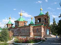 The Russian Orthodox Holy Trinity Cathedral in Karakol | |||
| |||
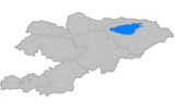
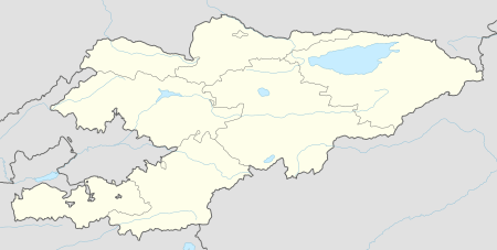 Karakol Location in Kyrgyzstan | |||
| Coordinates: 42°29′N 78°24′E / 42.483°N 78.400°E | |||
| Country |
| ||
| Region | Issyk-Kul Region | ||
| Area | |||
| • Total | 44 km2 (17 sq mi) | ||
| Elevation | 1,745 m (5,724 ft) | ||
| Population (2009)[1] | |||
| • Total | 66,294 | ||
| • Density | 1,500/km2 (3,900/sq mi) | ||
| Time zone | UTC+6 (KGT) | ||


Karakol (Kyrgyz: Каракол, Qaraqol/Karakol, قاراقول, Kyrgyz pronunciation: [qɑrɑqoɫ]), formerly Przhevalsk, is the fourth largest city in Kyrgyzstan, near the eastern tip of Lake Issyk-Kul in Kyrgyzstan, about 150 kilometres (93 mi) from the Kyrgyzstan-China border and 380 kilometres (240 mi) from the capital Bishkek. It is the administrative capital of Issyk-Kul Region. Its area is 44 square kilometres (17 sq mi), and its resident population was 66,294 in 2009 (both including Pristan'-Przheval'sk).[1] To the north, on highway A363, is Tyup and to the southwest Jeti-Ögüz resort.
History
A Russian military outpost founded on 1 July 1869, Karakol grew in the 19th century after explorers came to map the peaks and valleys separating Kyrgyzstan from China. In the 1880s Karakol's population surged with an influx of Dungans, Chinese Muslims fleeing warfare in China.
In 1888, the Russian explorer Nicholay Przhevalsky died in Karakol of typhoid, while preparing for an expedition to Tibet, the city was renamed Przhevalsk in his honor. After local protests, the town was given its original name back in 1921—a decision reversed in 1939 by Stalin to celebrate the centenary of the explorer's birth. Karakol then remained Przhevalsk until the demise of the Soviet Union in 1991. However the name has been retained by nearby Pristan'-Przheval'sk.
Nearby Issyk Kul Lake was used by the Soviet military as a testing site for torpedo propulsion and guidance systems, and Karakol was thus home to a sizable population of military personnel and their families. Karakol continues to be a major hub for visitors of Issyk Kul Lake.
Demographics
Karakol is fourth largest town in Kyrgyzstan after Bishkek, Osh, and Jalal-Abad. The population of Karakol, according to the Population and Housing Census of 2009, was 67,100.
| Historical populations in Karakol | |
|---|---|
| Year | Pop. |
| 1897 | 8,108 |
| 1907 | 13,948 |
| 1926 | 13,366 |
| 1970 | 46,394 |
| 1989 | 68,272 |
| 2009 | 67,100 |
| Source:[1][2][3][4][5] | |
Geography
Climate
Karakol features a humid continental climate (Dfb).
| Climate data for Karakol | |||||||||||||
|---|---|---|---|---|---|---|---|---|---|---|---|---|---|
| Month | Jan | Feb | Mar | Apr | May | Jun | Jul | Aug | Sep | Oct | Nov | Dec | Year |
| Average high °C (°F) | −4.7 (23.5) |
−2.9 (26.8) |
4.8 (40.6) |
14.0 (57.2) |
18.9 (66) |
23.1 (73.6) |
25.5 (77.9) |
25.0 (77) |
20.2 (68.4) |
12.7 (54.9) |
3.4 (38.1) |
−2.3 (27.9) |
11.5 (52.7) |
| Daily mean °C (°F) | −10.4 (13.3) |
−8.5 (16.7) |
−0.5 (31.1) |
7.8 (46) |
12.8 (55) |
16.7 (62.1) |
19.0 (66.2) |
18.2 (64.8) |
13.4 (56.1) |
6.4 (43.5) |
−1.9 (28.6) |
−7.6 (18.3) |
5.5 (41.8) |
| Average low °C (°F) | −16.1 (3) |
−14.0 (6.8) |
−5.8 (21.6) |
1.7 (35.1) |
6.8 (44.2) |
10.4 (50.7) |
12.5 (54.5) |
11.4 (52.5) |
6.7 (44.1) |
0.1 (32.2) |
−7.1 (19.2) |
−12.9 (8.8) |
−0.5 (31.1) |
| Average precipitation mm (inches) | 12 (0.47) |
14 (0.55) |
23 (0.91) |
39 (1.54) |
55 (2.17) |
54 (2.13) |
57 (2.24) |
55 (2.17) |
39 (1.54) |
31 (1.22) |
20 (0.79) |
14 (0.55) |
413 (16.28) |
| Average relative humidity (%) | 69.4 | 69.6 | 59.4 | 46.6 | 47.2 | 45.0 | 43.0 | 41.2 | 42.5 | 49.6 | 58.7 | 68.7 | 53.4 |
| Source #1: Weatherbase (humidity) [6] | |||||||||||||
| Source #2: Climate-Data.org (temp & precip) [7] | |||||||||||||
Sights

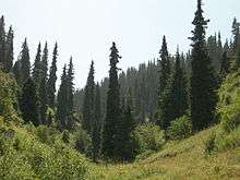
Karakol is one of Kyrgyzstan's major tourist destinations, serving as a good starting point for the excellent hiking, trekking, skiing and mountaineering in the high central Tian Shan to the south and east. Also this city is culturally rich by different ethnic groups that live here such as Dungan, Uigur, Kalmak, Uzbek, Russians and of course Kyrgyz. The city offers a great opportunity to discover other nationalities and cultures within the city.
Przhevalsky's grave, a memorial park and a small museum dedicated to his and other Russian explorations in Central Asia are some 9 kilometres (5.6 mi) north of Karakol at Pristan Przhevalsky, overlooking the Mikhailovka inlet of Issyk Kul Lake where the former Soviet torpedo testing facilities were located. Facilities themselves are still a closed, military area.
Karakol is famous among skiers and snowboarders from former USSR for its ski resort. Situated just 20 minutes from the town, the Karakol Ski Base provides services significantly better than those available at Shymbulak, a resort outside Almaty, and has cheaper prices. Unlike Shymbulak resort, the riding at Karakol includes forest areas as well as cleared trails.
Russian Orthodox cathedral
The cathedral was originally built of stone in 1872,[8] when Karakol was a garrison town established as an outpost on the edges of the Tsarist Russian Empire. It was destroyed in 1890 by an earthquake and the current cathedral was built out of wood on a brick base.[8] It took six years to complete, and was finally completed in 1895. During the period of construction, a yurt served the congregation as a church. It has seen considerable service, not just as a church. During an anti-Russian uprising in 1916 its monks were brutally murdered.[8]
Over the years, particularly following the Revolution in 1917, it has been used as an educational center housing a school, ladies’ gymnasium and an institution of Higher Education; a Sports Hall; a Theater; a Dance Hall and even as a Coal Store. Then, in 1991, following the collapse of the Soviet Union and the Independence of Kyrgyzstan, the local authority once again gave the building back to the church, with the proviso that all further restorations were their responsibility.
Dungan mosque
The Issyk-kul Central Mosque of Karakol city was built by initiative of Ibrahim Aji. He invited the famous Beijing architect Chou Seu and 20 carvers with the skills of traditional Chinese architecture and composition techniques for building the mosque. The construction of outbuildings and other work involved local craftsmen. Construction of the mosque began in 1904 and was completed in 1910.[8] Ingenious techniques allowed the builders to build the mosque with no nails.[8] The mosque holds 42 based pillars and encircling the building is multi-tiered wooden cornice, decorated with images of plants like grapes, pomegranates, pears and peaches. From 1929 to 1947 (during the Soviet era) the mosque was used as a storehouse. In 1947, the building was given to the Muslim community and continues to function as a mosque. It is registered as a historical monument and protected by law. Today the mosque is open to visitors.
Prjevalski Museum
Nikolay Przhevalsky was one of the first Russian Scientist-Geographer to start detailed studies of the geography, flora and fauna of the Central Asian countries. Beginning from 1870, he arranged 4 large expeditions to Mongolia, China and Tibet.[8] During his expeditions he revealed the exact directions of the mountain ranges and borders of the Tibet Mountains. He described the nature, relief, climate, flora and fauna in the territories under his study and discovered over 200 plant species. Przhevalsky also collected an enormous zoological collection which comprised several thousand species of plants, animals, birds, fishes and insects. In the year of 1888, he died from typhoid fever on the eve of his fifth expedition to Central Asia; he was buried on the Issyk-Kul lakeside not far from the city of Karakol.[8] The Memorial Museum of N. M. Przhevalsky was opened on 29 April 1957 in Karakol.
Karakol Historical Museum
This small museum was the pre-revolutionary summer home of the Iliana merchant family. During the turbulent years of 1918-20 the building earned its socialist stripes as headquarters of the Regional Revolutionary Committee, and was subsequently transformed into a museum by order of the Soviet Council of Ministers in 1948. Scythian artifacts include enormous bronze pots retrieved from Lake Issyk-Kul, displayed alongside exhibits on petroglyphs in the area. Besides a comprehensive display of traditional Kyrgyz punched leather work, felt wall hangings and woven yurt decorations, the museum has a colorful collection of national costumes, examples of finely worked silver jewellery and a good exhibition of Kyrgyz applied art. One hall covers the region's flora and fauna - much of which is endangered and listed in the 'Red Book' (a Soviet inventory of protected species). The museum is also worth visiting to gain a Soviet perspective of history in the region. A couple of walls relating to Kyrgyz union with Russia and the subsequent revolution are now historical artifacts in themselves.
Bugu-Ene Zoo
Karakol Zoological Park was founded in 1987. This is the only zoo in Kyrgyzstan. After the demise of the Soviet Union the economics of the country collapsed, and it concerned the newly created object culture. In 2001, closing the zoo was considered. However, sponsors were found, which not only allowed to preserve the wildlife area, but also allowed to keep it in a relatively prosperous state. Nowadays the buildings, cages and cells are not new, but in very good condition. There are Japanese macaques, bears, wolf, deer, camels, Przewalski's horse, peacock and many others.
Animal Market
Early on Sunday mornings one of Kyrgyzstan’s biggest animal markets takes place around 2 km north of central Karakol. Locals loading and unloading sheep into the back of a sedan is not an uncommon sight. The setting amid semi-derelict flour mills might seem unprepossessing, but on clear days the backdrop of white-topped mountains is more striking from here than from the town center. A series of earthen unloading platforms lead north. Jostle through the chaos to reach a bigger main compound one block north, where you’ll find horse sales and vendors of beautiful embossed leather saddlery. On foot the bazaar is about 25 minutes’ walk from City Center. (Resource: Lonely Planet)
Jeti-Ögüz
Jeti-Ögüz is famous for its large, red sedimentary rocks, about 2,200m. The rock have been carved out by a river from the Terskey Alatoo mountains. Years of weathering have split the rocks into seven parts. The forms of the rocks are similar to the head of the seven bulls, “Jeti”-means seven and “Ögüz”-means bull in Kyrgyz. Another beautiful place to see is Broken Heart. This is a reddish rock shaped like a broken heart. For this rock, there are several legends: long ago a king who was very rich and had many wives went hunting. One day he saw a beautiful girl with black long hair. He fall in love with her at first sight, and wanted to marry her. However she was from a poor family and was already engaged. Her family ran away from the king when they learned that he wanted their daughter. But the king caught them, killed her fiancé and her family. Her heart was torn by sadness and the Broken Heart appeared in that place.
Barskoon Waterfall
Barskoon Waterfall is a geological protected area located in Jeti-Ögüz District of Issyk-Kul Region of Kyrgyzstan, 90 km to the south-west of Karakol on one of the tributaries of Barskaun River. It was established in 1975. Within the Barskoon Valley there are two waterfalls on top of the mountain and the mountainside. At the foot of the mountain one can enjoy the beautiful Barskoon River. During the summertime, people build yurts there, where you can try the Kyrgyz traditional drink Kymys while enjoying the beauty of the landscape.
The Fairy Tale Canyon / Skazka Canyon
The canyon was named because of its bizarre rocky landscape, which for many years has been transformed by wind into amazing sculptures and formations. Some formations look like The Great Wall of China and you can also find other formations that look like snakes, dragons, sleeping giants and even whole castles. From here opens unusual view on a majestic panorama of lake and blue caps of mountains. It’s an excellent destination for children and adults alike and makes for an easy hike close to the lake.
Salty Lake
The salty lake known as a “Dead Lake of Kyrgyzstan”. The lake was opened as a tourist destination in 2001. The water is so salty that one can read a newspaper while floating on the surface. The water contains about 132 gram of salt per liter. This lake is also popular as a “medical tour”. Mud is superheated deep beneath the earth’s surface. Many locals believe that it has healing properties.
Famous people born in Karakol
- Grigoriy Shemyakin, born in 1906, Hero of the Soviet Union, one of Panfilov's Twenty-Eight Guardsmen
Sister cities

References
- 1 2 3 "2009 population census of the Kyrgyz Republic: Issyk-Kul Region" (PDF). Archived from the original (PDF) on 10 August 2011. Retrieved 2017-01-04.
- ↑ Первая всеобщая перепись населения Российской Империи 1897 г. Наличное население в губерниях, уездах, городах Российской Империи (без Финляндии). Семиреченская область Archived 29 June 2011 at the Wayback Machine. (First General Russian Empire Census of 1897. Population in provinces, districts, towns of Russian Empire (without Finland). Semirech'e Province (Demoscope.ru) (in Russian)
- ↑ Review of Semirech'e Oblast for 1907 (Обзор Семиреченской области за 1907 год), Verniy: Publishing House of Semirech'e Provincial Administration, 1908
- ↑ Всесоюзная перепись населения 1926 года : Киргизская АССР. (All-Union Census of 1926: Kyrgyz ASSR), Moscow: CSU SSSR, 1928
- ↑ Численность наличного населения городов, поселков городского типа, районов и районных центров СССР по данным переписи на 15 января 1970 года по республикам, краям и областям (кроме РСФСР) Archived 9 February 2011 at the Wayback Machine.
- ↑ "The Climate of Karakol". Weatherbase. Retrieved 31 July 2014.
- ↑ "Climate: Karakol". Climate-Data.org. Retrieved 19 May 2016.
- 1 2 3 4 5 6 7 Lake Issyk-Kul Pamphlet and Map. Bishkek: Rarity Firm, LTD.
|access-date=requires|url=(help)
External links
| Wikimedia Commons has media related to Karakol. |

- web page Karakol
Administrative seats of the regions of Kyrgyzstan | |||
|---|---|---|---|
| North Krygyzstan |
|  | ||||||||||
|---|---|---|---|---|---|---|---|---|---|---|---|---|
| South Krygyzstan |
| |||||||||||
Coordinates: 42°29′N 78°24′E / 42.483°N 78.400°E
| Authority control |
|---|