Ak-Talaa District
| Ak-Talaa | |
|---|---|
| Raion | |
| Ак-талаа району | |
 | |
 | |
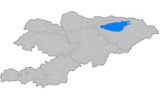
| Country | Kyrgyzstan |
| Region | Naryn Region |
| Area | |
| • Total | 7,266 km2 (2,805 sq mi) |
| Population (2009) | |
| • Total | 30,643 |
| • Density | 4.2/km2 (11/sq mi) |
| Time zone | UTC+5 (GMT +5) |
Ak-Talaa (Kyrgyz: Ак-талаа району) is a raion (district) of Naryn Region in Kyrgyzstan. The capital lies at Baetov.[1] Its area is 7,266 square kilometres (2,805 sq mi), and its resident population was 30,643 in 2009.[2]
Rural communities and villages
In total, Ak-Talaa District include 19 settlements in 13 rural communities (aiyl okmotus). Each rural community can consist of one or several villages. The rural communities and settlements in the Ak-Talaa District are:[3]
- Ak-Tal aiyl okmotu (1: center - village: Ak-Tal)
- Ak-Chiy aiyl okmotu (2: center - village: Ak-Chiy; and also village Jany-Tilek)
- Baetov aiyl okmotu (2: center - village: Baetov; and also village Kayyndy-Bulak)
- Terek aiyl okmotu (2: center - village: Terek; and also village Orto-Syrt)
- Kara-Byurgen aiyl okmotu (1: center - village: Kara-Byurgen)
- Kongorchok aiyl okmotu (1: center - village: Kongorchok)
- Jerge-Tal aiyl okmotu (2: center - village: Cholok-Kayyn; and also village Jerge-Tal)
- Kosh-Debe aiyl okmotu (1: center - village: Kosh-Debe)
- Kyzyl-Beles aiyl okmotu (1: center - village: Kadyraly)
- Jany-Talap aiyl okmotu (1: center - village: Jany-Talap)
- Togolok-Moldo aiyl okmotu (1: center - village: Kara-Oy)
- Kek-Jar aiyl okmotu (2: center - village: Ak-Kyya; and also village Kek-Jar)
- Ugyut aiyl okmotu (2: center - village: Ugyut; and also village Baygenchek)
References
- ↑ Enrin.grida.no Archived 2009-08-02 at the Wayback Machine.
- ↑ "2009 population census of the Kyrgyz Republic: Naryn Region" (PDF). Archived from the original (PDF) on 25 October 2012. Retrieved 2016-06-15.
- ↑ "{title}". Archived from the original on 2010-02-09. Retrieved 2010-07-11.
| North Krygyzstan |
|  | ||||||||||
|---|---|---|---|---|---|---|---|---|---|---|---|---|
| South Krygyzstan |
| |||||||||||
Coordinates: 41°16′00″N 74°56′48″E / 41.26667°N 74.94667°E
This article is issued from
Wikipedia.
The text is licensed under Creative Commons - Attribution - Sharealike.
Additional terms may apply for the media files.