Jayyl District
| Jayyl Жайыл району | |
|---|---|
| Raion | |
 | |
| Country | Kyrgyzstan |
| Region | Chuy Region |
| Area | |
| • Total | 3,435 km2 (1,326 sq mi) |
| Population (2009) | |
| • Total | 92,645 |
| • Density | 27/km2 (70/sq mi) |
| Time zone | UTC+5 (GMT +5) |
| Website | http://www.jaiyl.kg/ |
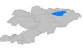
Jayyl (Kalinin District until May 1993) is a raion (district) of Chuy Region in northern Kyrgyzstan. Its area is 3,453 square kilometres (1,333 sq mi), and its resident population was 92,645 in 2009.[1] The capital lies at Kara-Balta. It also administers an exclave in the southwestern heel of Chuy Region (the Suusamyr Valley, not on map at right), separated from the rest of the Jayyl District by the Panfilov District.[2]
Populated places
In total, Jayyl District include 1 town and 36 settlements in 12 rural communities (aiyl okmotus). Each rural community can consist of one or several villages. The rural communities and settlements in the Jayyl District are:[3][4]
- town Kara-Balta
- Ak-Bashat Aiyl Okmotu (4: center - village: Ak-Bashat; and also villages: Aydarbek, Aral and Novonikolayevka)
- Jayyl Aiyl Okmotu (2: center - village: Jayyl; and also village: Alekseyevka)
- Kara-Suu Aiyl Okmotu (2: center - village: Kara-Suu; and also village: Stavropolovka)
- Krasnovostochnyi Aiyl Okmotu (3: center - village: Kalininskoye; and also Kaldyk and Kara-Döbö)
- Kyzyl-Dyykan Aiyl Okmotu (2: center - village: Kyzyl-Dyykan; and also village: Petropavlovka)
- Poltavka Aiyl Okmotu (3: center - village: Poltavka; and also villages: Orto-Suu and Maltabar)
- Sary-Bulak Aiyl Okmotu (2: center - village: Sary-Bulak; and also village: Mongoldor)
- Sarykoo Aiyl Okmotu (6: center - village: Iyri-Suu; and also villages: Eriktuu, Altyn, Fedorovka, Jeken and Jon-Aryk)
- Sosnovka Aiyl Okmotu (1: center - village: Sosnovka)
- Stepnoe Aiyl Okmotu (1: center - village: Stepnoye)
- Suusamyr Aiyl Okmotu (7: center - village: Suusamyr; and also villages: Kojomkul, Tunuk, Birinchi May, Kyzyl-Oy, Karakol and Kaysar)
- Taldy-Bulak Aiyl Okmotu (3: center - village: Böksö-Jol; and also villages: Kayyrma and Bekitay)
References
- ↑ "2009 population census of the Kyrgyz Republic: Chuy Region" (PDF). Archived from the original (PDF) on 10 August 2011. Retrieved 2010-03-12.
- ↑ Enrin.grida.no Archived 2009-08-02 at the Wayback Machine.
- ↑ "Archived copy". Archived from the original on 2010-02-09. Retrieved 2010-03-14.
- ↑ Web-site of Jayyl District
| North Krygyzstan |
|  | ||||||||||
|---|---|---|---|---|---|---|---|---|---|---|---|---|
| South Krygyzstan |
| |||||||||||
Coordinates: 42°49′N 73°51′E / 42.817°N 73.850°E
This article is issued from
Wikipedia.
The text is licensed under Creative Commons - Attribution - Sharealike.
Additional terms may apply for the media files.