Kadamjay District
| Kadamjay | |
|---|---|
| Raion | |
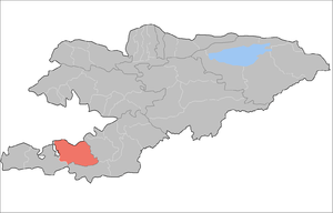 | |
| Country | Kyrgyzstan |
| Region | Batken Region |
| Seat | Pulgon |
| Area | |
| • Total | 2,373 sq mi (6,146 km2) |
| Population (2009) | |
| • Total | 157,597 |
| • Density | 66/sq mi (26/km2) |
| Time zone | UTC+5 (GMT +5) |
Kadamjay District (Kyrgyz: Кадамжай району; Russian: Кадамжайский район) is a district (raion) in Batken Region, in south-western Kyrgyzstan. The district capital lies at Pulgon.[1] The district area is 6,146 square kilometres (2,373 sq mi), and its resident population was 157,597 in 2009.[2] The largest town of the district, Kadamjay, is located between the cities of Khaidarkan (Aidarken) and Kyzyl-Kiya.
The district is thought to have the second largest mercury-antimony deposit in the world.[3] Kadamjay Antimony Factory is one of the biggest factories in Kyrgyzstan. Khaidarkan Mercury Plant, built in 1942, was reported, as of 2005, to produce 300 to 600 metric tons of mercury per year.
Ak-Su (white river) is the river which passes through Kadamjay. Jiydelik lake is a favorite picnic spot.
Rural communities and villages
In total, Kadamjay District include 2 cities and 103 villages in 13 rural communities (aiyl okmotus). Each rural community can consist of one or several villages. The rural communities and settlements in the Kadamjay District are:[4][5]
- city Aydarken
- city Kadamjay
- Ak-Turpak aiyl okmotu (14: center - village: Jany-Jer; and also villages Ak-Turpak, Kalacha, Kara-Tumshuk, Kyzyl-Korgon, Otukchu, Sary-Kamysh, Tokoy, Chogorok, Chong Kara, Jash-Tilek, Orukzar, Ming-Chinar and Kelechek)
- Alga aiyl okmotu (6: center - village: Alga; and also villages Adyr, Sak-Sak, Shyrban, Chunkur-Kyshtak and Jany-Chek)
- Birlik aiyl okmotu (11: center - village: Ormosh; and also villages Bel', Jal, Jany Korgon, Kichi-Aydarken, Molo, Sur, Syrt, Teskey, Eshme and Chechme)
- Absamat Masaliev aiyl okmotu (8: center - village: Kara-Debe; and also villages Olagysh, Kakyr, Kojo, Kon, Alysh, Tash-Korgon and Leskhoz)
- Kotorma aiyl okmotu (10: center - village: Kyzyl-Bulak; and also villages Ak-Kiya, Gayrat, Jalgyz-Bulak, Kara-Oot, Kara-Shoro, Kesken-Tash, Keterme, Tamasha and Langar)
- Maidan aiyl okmotu (13: center - village: Kara-Jygach; and also villages Austan, Kara-Kyshtak, Karool, Kerege-Tash, Maydan, Pum, Kara-Dobo, Isfayram, Sary-Altyn, Bak, Jany-Abad and Akimbek)
- Markaz aiyl okmotu (6: center - village: Markaz; and also villages Arpa-Say, Dostuk, Kek-Talaa, Mayak and Pyldarak)
- Orozbek aiyl okmotu (5: center - village: Orozbekovo; and also villages Kuldu, Tash-Kyya, Pulgon and Chal-Tash)
- Uch-Korgon aiyl okmotu (12: center - village: Uch-Korgon; and also villages Valakish, Kakyr, Kalacha, Kaltak, Sulaymanabad, Raz'ezd, Sukhana, Chauvay, Boz, Kambarabad and Tajik Kyshtak)
- Khalmion aiyl okmotu (14: center - village: Khalmion; and also villages Baymaala, Gulduromo, Jayny-Aiyl, Joshuk, Irilek, Kek-Tal, Kurulush, Noogardan, Tah-Dobo, Yntymak, Chekelik and Shady)
- Kyrgyz-Kyshtak aiyl okmotu (4: center - village: Kyrgyz-Kyshtak; and also villages Kojo-Korum, Kaytpas and Byurgendyu)
- Chauvay aiyl okmotu (1: center - village: Chauvay)
- Sovet aiyl okmotu (1: center - village: Sovetskiy)
External links
- A site about Kadamzhay (in English) (in Russian)
References
- ↑ Enrin.grida.no Archived 2009-08-02 at the Wayback Machine.
- ↑ "2009 population census of the Kyrgyz Republic: Batken Region" (PDF). Archived from the original (PDF) on 10 August 2011. Retrieved 2013-05-16.
- ↑ "Primary Mercury Mining"
- ↑ List of Rural Communities of Kyrgyzstan Archived 2010-02-09 at the Wayback Machine.
- ↑ 2012 Law on the transformation of individual urban settlements of the Kyrgyz Republic and relating them to the category of village or city
| North Krygyzstan |
|  | ||||||||||
|---|---|---|---|---|---|---|---|---|---|---|---|---|
| South Krygyzstan |
| |||||||||||