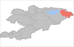
Ak-Suu is a raion (district) of Issyk-Kul Region in eastern Kyrgyzstan. The administrative center lies at the village Ak-Suu.[2] Its area is 9,917 square kilometres (3,829 sq mi), and its resident population was 63,686 in 2009.[1]
Demographics
The district population, according to the Population and Housing Census of 2009, was 63,686.[1] The population density was 6.4 people per square kilometer.
| Historical populations in Ak-Suu District |
|---|
| Year | Pop. | ±% |
|---|
| 1970 | 44,046 | — |
|---|
| 1979 | 50,236 | +14.1% |
|---|
| 1989 | 57,109 | +13.7% |
|---|
| 1999 | 57,160 | +0.1% |
|---|
| 2009 | 63,686 | +11.4% |
|---|
| Note: enumerated de facto population; Source:[1] |
Ethnic composition
According to the 2009 Census, the ethnic composition (de jure population) of the Ak-Suu District was:[1]
| Ethnic group | Population | Proportion of Ak-Suu District population |
| Kyrgyzs | 7004563690000000000♠56,369 | 88.5% |
| Russians | 7003288400000000000♠2,884 | 4.5% |
| Kalmyks | 7003280500000000000♠2,805 | 4.4% |
| Kazakhs | 7002916000000000000♠916 | 1.5% |
| Uygurs | 7002201000000000000♠201 | 0.3% |
| Tatars | 7002146000000000000♠146 | 0.2% |
| Ukrainians | 7002125000000000000♠125 | 0.2% |
| Uzbeks | 7002110000000000000♠110 | 0.2% |
| other groups | 7002130000000000000♠130 | 0.2% |
Populated places
In total, Ak-Suu District include 39 settlements in 14 rural communities (aiyl okmotus). Each rural community can consist of one or several villages. The rural communities and settlements in the Ak-Suu District are:[3][1][4]
- Ak-Bulun aiyl okmotu (3: center - village: Ak-Bulun; and also villages Ak-Bulak and Toktogul)
- Beryu-Bash aiyl okmotu (2: center - village: Beryu-Bash; and also village Cherik)
- Jyrgalan aiyl okmotu (1: center - village: Jyrgalan)
- Kara-Jal aiyl okmotu (4: center - village: Tegizchil, and also villages Jany-Aryk, Kara-Jal and Boz-Bulun)
- Karakol aiyl okmotu (2: center - village: Karakol; and also village Cholpon)
- Kerege-Tash aiyl okmotu (5: center - village: Sary-Kamysh; and also villages Kerege-Tash, Kayyrma-Aryk, Novokonstantinovka and Pioner)
- Novovoznesenovka aiyl okmotu (3: center - village: Novovoznesenovka; and also villages Boz-Uchuk and Ichke-Jergez)
- Oktyabrskiy aiyl okmotu (4: center - village: Oktyabrskoye; and also villages Jol-Kolot, Otuz-Uul and Uch-Kaynar)
- Otradnoye aiyl okmotu (3: center - village: Otradnoye; and also villages Orlinoye and Shapak)
- Ak-Chiy aiyl okmotu (3: center - village: Ak-Chiy; and also villages Kachybek and Sovetskoye)
- Tepke aiyl okmotu (3: center - village: Tepke; and also villages Jyldyz and Kurbu)
- Teploklyuchenka aiyl okmotu (2: center - village: Teploklyuchenka; and also village Lesnoye)
- Chelpek aiyl okmotu (3: center - village: Chelpek; and also villages Burma-Suu and Tash-Kyya)
- Engilchek aiyl okmotu (1: center - village: Engilchek)