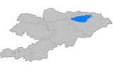
Jeti-Ögüz District
| Jeti-Ögüz | |
|---|---|
| Raion | |
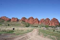 The Jeti-Ögüz rock formation from which Jeti-Ögüz District gets its name, and near-by resort. | |
 | |
| Country | Kyrgyzstan |
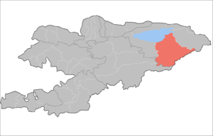
| Region | Issyk-Kul Region |
| Area | |
| • Total | 14,499 km2 (5,598 sq mi) |
| Population (2009) | |
| • Total | 82,085 |
| • Density | 5.7/km2 (15/sq mi) |
| Time zone | UTC+5 (GMT +5) |
Jeti-Ögüz or Jeti-Oguz (Kyrgyz: Жети-өгүз [dʒeti œɣýz], seven bulls) is a raion (district) of Issyk-Kul Region in north-eastern Kyrgyzstan. The capital lies at Kyzyl-Suu,[1] Its area is 14,499 square kilometres (5,598 sq mi), and its resident population was 82,085 in 2009.[2] and the province comprises much of the eastern end of the Teskey Ala-Too Range.
Geography
The Terskey Alatau, Ak-Shiyrak Range, Borkoldoy Too, Jetim Bel Range, and Kakshaal Too spread across the Jeti-Ögüz District. Major valleys include Issy-Kul Valley, Upper Naryn Valley, Ak-Shiyrak Valley and so on. The district contains deposits of ores of tin, tungsten, copper and other metals. Among its large rivers are the Naryn River, Saryjaz River, Barskoon River, Jeti-Ögüz River, etc.
Rural communities and settlements
In total, Jeti-Ögüz District include 42 villages located in 13 rural communities (aiyl okmotus). Each rural community may consist of one or several villages. The rural communities and settlements in the Jeti-Ögüz District are:[3]
- Ak-Debe aiyl okmotu (4: center - village: Munduz; and also villages Ak-Debe, An-Osten and Tilekmat)
- Ak-Shyyrak aiyl okmotu (1: center - village: Ak-Shyyrak)
- Barskoon aiyl okmotu (2: center - village: Barskoon; and also village Karakol)
- Darkan aiyl okmotu (1: center - village: Darkan)
- Jargylchak aiyl okmotu (4: center - village: Ak Terek; and also villages Jenish, Kichi Jargylchak and Chong Jargylchak)
- Jeti-Ögüz aiyl okmotu (7: center - village: Jeti-Ögüz; and also villages Ak-Kochkor, Jele-Debe, Jeti-Ögüz resort, Kabak, Taldy-Bulak and Chyrak)
- Yrdyk aiyl okmotu (5: center - village: Baltabay; and also villages Jon-Bulak, Kytay, Konkino and Yrdyk)
- Lipenka aiyl okmotu (4: center - village: Lipenka; and also villages Bogatyrovka, Zelenyi Gay and Ichke-Bulun)
- Orgochor aiyl okmotu (3: center - village: Orgochor; and also villages Boz-Beshik and Kurgak-Ayryk)
- Kyzyl-Suu aiyl okmotu (4: center - village: Kyzyl-Suu; and also villages Jalgyz-Oruk, Kaynar and Pokrovskaya)
- Aldashev aiyl okmotu (3: center - village: Saruu; and also villages Juuku and Issyk-Kel)
- Svetlaya Polyana aiyl okmotu (2: center - village: Svetlaya Polyana; and also village Chong Kyzyl-Suu)
- Tamga aiyl okmotu (2: center - village: Tamga; and also village Tosor)
Gallery
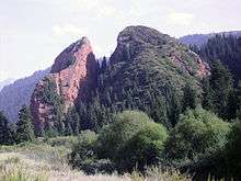 Broken Heart Rock
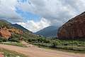 Near the end of Juuku Gorge
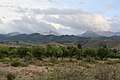 The Teskey Ala-Too range as seen from the beach at Ak Terek
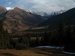 The mountains a bit south of Jeti Ögüz rock formation
References
- ↑ Enrin.grida.no Archived 2009-08-02 at the Wayback Machine.
- ↑ "2009 population census of the Kyrgyz Republic: Issyk-Kul Region" (PDF). Archived from the original (PDF) on 10 August 2011. Retrieved 2017-01-04.
- ↑ List of rural communities of Kyrgyzstan Archived 2010-02-09 at the Wayback Machine.
| North Krygyzstan |
|  | ||||||||||
|---|---|---|---|---|---|---|---|---|---|---|---|---|
| South Krygyzstan |
| |||||||||||

Coordinates: 42°20′23″N 78°00′06″E / 42.339596°N 78.001701°E