Leilek District
| Leilek | |
|---|---|
| Raion | |
 | |
| Country | Kyrgyzstan |
| Region | Batken Region |
| Capital | Isfana |
| Area | |
| • Total | 1,797 sq mi (4,653 km2) |
| Population (2009) | |
| • Total | 116,861 |
| Time zone | UTC+5 (GMT +5) |
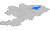
Leilek is a raion (district) of Batken Region in south-western Kyrgyzstan. It borders with Batken District in the east, and Tajikistan in the south, west, and north. Its area is 4,653 square kilometres (1,797 sq mi), and its resident population was 116,861 in 2009.[1] The capital lies at Isfana.[2]
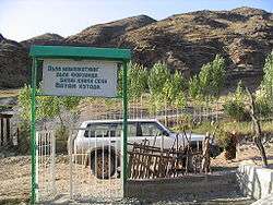 A Batken town's school closely located to Leilek.
Geography
Leilek District is located at northern slopes of Turkestan Range, high foothills, and Isfara-Isfana Valley with lowest point of Kyrgyzstan - 394 meters above sea level.
Towns, rural communities and villages
In total, Leilek District include 1 town and 46 villages in 9 rural communities (aiyl okmotus). The rural communities and settlements in the Leilek District are:[3]
- town of district significance Isfana (including 6 villages: Myrza-Patcha, Samat, Chimgen, Taylan, Ak-Bulak and Golbo)
- Ak-Suu aiyl okmotu (4: center - village: Ak-Suu; and also villages Alga, Jenish and Suu-Bashi)
- Beshkent aiyl okmotu (5: center - village: Beshkent; and also villages Imeni Karla Marksa, Kayragach, 50 Let SSSR and Eski Oochu)
- Margun aiyl okmotu (4: center - village: Margun; and also villages Churbek, Darkhum and Dargaz)
- Jangy Jer aiyl okmotu (4: center - village: Tsentralnoye; and also villages Arka, Dostuk and Jashtyk)
- Leilek aiyl okmotu (5: center - village: Korgon; and also villages Kara-Suu, Leilek, Chuyanchy and Ak-Terek)
- Katran okmotu (3: center - village: Katran; and also villages Jangy-Turmush and Özgörüsh)
- Kulundu aiyl okmotu (5: center - village: Kulundu; and also villages Bulak-Bashy, Internatsional'noye, Kommunizm and Imeni Lenina)
- Sambula aiyl okmotu (4: center - village: Andarak; and also villages Iskra, Kök-Tash and Kommuna)
- Toguz-Bulak aiyl okmotu (6: center - village: Toguz-Bulak; and also villages Aykol, Kara-Bulak, Aybike (formerly called Madaniyat), Min-Jigach (formerly called 50 Let Kirgizii) and Gordoy (formerly called Imeni Chapaeva))
References
- ↑ "2009 population census of the Kyrgyz Republic: Batken Region" (PDF). Archived from the original (PDF) on 10 August 2011. Retrieved 2013-05-16.
- ↑ Enrin.grida.no Archived 2009-08-02 at the Wayback Machine.
- ↑ List of Rural Communities of Kyrgyzstan Archived 2010-02-09 at the Wayback Machine.
| North Krygyzstan |
|  | ||||||||||
|---|---|---|---|---|---|---|---|---|---|---|---|---|
| South Krygyzstan |
| |||||||||||
This article is issued from
Wikipedia.
The text is licensed under Creative Commons - Attribution - Sharealike.
Additional terms may apply for the media files.