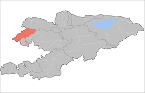
Chatkal District
| Chatkal | |
|---|---|
| Raion | |
 | |
| Country | Kyrgyzstan |
| Region | Jalal-Abad Region |
| Area | |
| • Total | 4,608 km2 (1,779 sq mi) |
| Population (2009) | |
| • Total | 22,490 |
| • Density | 4.9/km2 (13/sq mi) |
| Time zone | UTC+5 (GMT +5) |
Chatkal is a raion (district) of Jalal-Abad Region in western Kyrgyzstan. The capital lies at Kanysh-Kyya.[1] Its area is 4,608 square kilometres (1,779 sq mi), and its resident population was 22,490 in 2009.[2]
Urban-type settlements, rural communities and villages
In total, Chatkal District includes 11 settlements in 4 rural communities (aiyl okmotus). Each rural community can consist of one or several villages. The rural communities and settlements in the Chatkal District are:[3][4]
- Kanysh-Kyya aiyl okmotu (6: center - village: Kanysh-Kyya; and also villages Aygyr-Jar, Bashky-Terek, Korgon-Say, Kyzyl-Tokoy and Chakmak-Suu)
- Jangy-Bazar aiyl okmotu (3: center - village: Jangy-Bazar; and also villages Ak-Tash and Kurulush)
- Sumsar aiyl okmotu (1: center - village: Sumsar)
- Terek-Say aiyl okmotu (1: center - village: Terek-Say)
References
- ↑ Enrin.grida.no Archived August 2, 2009, at the Wayback Machine.
- ↑ 2009 population census of the Kyrgyz Republic: Jalal-Abad Region at the Wayback Machine (archived 10 August 2011)
- ↑ List of rural communities of Kyrgyzstan Archived 2010-02-09 at the Wayback Machine.
- ↑ 2012 Law on the transformation of individual urban settlements of the Kyrgyz Republic and relating them to the category of village or city
| North Krygyzstan |
|  | ||||||||||
|---|---|---|---|---|---|---|---|---|---|---|---|---|
| South Krygyzstan |
| |||||||||||
This article is issued from
Wikipedia.
The text is licensed under Creative Commons - Attribution - Sharealike.
Additional terms may apply for the media files.