Sebastia, Nablus
| Sebastiyah | |
|---|---|
| Other transcription(s) | |
| • Arabic | سبسطية |
| • Also spelled |
Sabastiya (official) Sebaste (unofficial) |
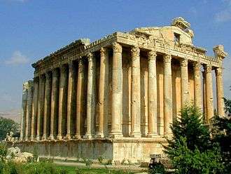
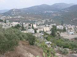 View of Sebastiyah, 2009 | |
 Sebastiyah Location of Sebastiyah within Palestine | |
| Coordinates: 32°16′34″N 35°11′43″E / 32.27611°N 35.19528°ECoordinates: 32°16′34″N 35°11′43″E / 32.27611°N 35.19528°E | |
| Palestine grid | 168/186 |
| Governorate | Nablus |
| Government | |
| • Type | Municipality (from 1997) |
| • Head of Municipality | Ma’amun Harun Kayed[1] |
| Area | |
| • Jurisdiction | 4,810 dunams (4.8 km2 or 1.9 sq mi) |
| Population (2007) | |
| • Jurisdiction | 4,114 |
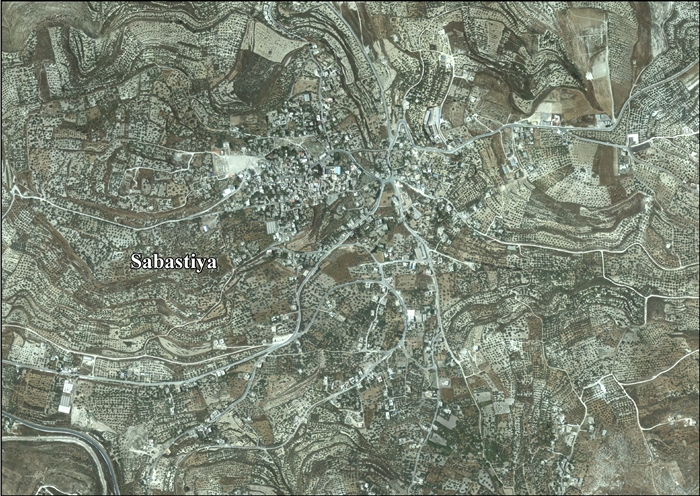
Sebastia (Arabic: سبسطية, Sabastiyah; Greek: Σεβαστη, Sevastee; Hebrew: סבסטיה, Sebasti; Latin: Sebaste) is a Palestinian village of over 4,500 inhabitants,[2] located in the Nablus Governorate of the West Bank some 12 kilometers northwest of the city of Nablus.[3] The village's total area is 4,810 dunums, the built up area of which comprises 150 dunums. Much of the village lands (42%) are located in Area C under the Oslo Accords.[4] It is the home of Nabi Yahya Mosque, a former Crusader cathedral.
History and archaeology
Antiquity
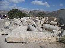
According to Josephus, the original name of the town was Shomron, before King Herod renamed it in honor of Augustus Caesar.[5] The Greek sebastos, "venerable", translates the Latin epithet augustus.[6] According to the Hebrew Bible it was settled by several Israelite tribes, "in ancient times."[7] Sebastia is home to a number of important archaeological sites.[8][9] The ancient site of Samaria-Sebaste is located just above the built up area of the modern day village on the eastern slope of the hill.[10] The ruins dominate the hillside and comprise remains from six successive cultures dating back more than 10,000 years: Canaanite, Israelite, Hellenistic, Herodian, Roman and Byzantine.[11]
The city was destroyed by Alexander the Great in 331 BCE, and was destroyed again by John Hyrcanus in 108 BCE.[12] Pompey rebuilt the town in the year 63 BCE. In 27 BCE, Augustus Caesar gave it to Herod the Great.[13] Herod expanded and renovated the city, bringing in six-thousand new inhabitants, and named it "Sebaste", meaning "Augustus", in the Emperor's honor.[12][14] Herod the Great had his sons Alexander and Aristobulus brought to Sebaste, and strangled in 7 BCE after a trial in Berytus and with the approbation of Caesar.[15]
Sherds from the late Roman,[16] Byzantine,[16][17] Early Moslem[16] and Medieval eras have been found here.[16]
Medieval period
Sebastia was the seat of a bishop in the Crusader Kingdom of Jerusalem. It is mentioned in the writings of Yaqut al-Hamawi (1179–1229), the Syrian geographer, who situates it as part of the Filastin Province of Jerusalem, located two days from that city, in the Nablus District. He also writes, "There are here the tombs of Zakariyyah and Yahya, the son of Zakariyyah (John the Baptist), and of many other prophets and holy men."[18]
Ottoman era
Sebastia was incorporated into the Ottoman Empire in 1517 with all of Palestine, and in 1596 it appeared in the tax registers as being in the Nahiya of Jabal Sami of the Liwa of Nablus. It had a population of 20 households and 3 batchelors, all Muslim. The villagers paid taxes on wheat, barley, summer crops, olive trees, occasional revenues, goats and/or beehives; a total of 5,500 akçe.[19]
The French explorer Victor Guérin visited the village in 1870 and found it to have less than a thousand inhabitants.[20]
In 1882, the Palestine Exploration Fund's Survey of Western Palestine described Sebastia as "A large and flourishing village, of stone and mud houses, on the hill of the ancient Samaria. The position is a very fine one; the hill rises some 400 to 500 feet above the open valley on the north, and is isolated on all sides but the east, where a narrow saddle exists some 200 feet lower than the top of the hill. There is a flat plateau on the top, on the east end of which the village stands, the plateau extending westwards for over half a mile. A higher knoll rises from the plateau, west of the village, from which a fine view is obtained as far as the Mediterranean Sea. The whole hill consists of soft soil, and is terraced to the very top. On the north it is bare and white, with steep slopes, and a few olives; a sort of recess exists on this side, which is all plough-land, in which stand the lower columns. On the south a beautiful olive-grove, rising in terrace above terrace, completely covers the sides of the hill, and a small extent of open terraced-land, for growing barley, exists towards the west and at the top. The village itself is ill-built, and modern, with ruins of a Crusading church of Neby Yahyah (St. John the Baptist), towards the northwest. [..]
A sarcophagus lies by the road on the north-east, but no rock-cut tombs have as yet been noticed on the hill, though possibly hidden beneath the present plough-land. There is a large cemetery of rock-cut tombs to the north, on the other side of the valley. The neighbourhood of Samaria is well supplied with water. In the months of July and August a stream was found (in 1872) in the valley south of the hill, coming from the spring (Ain Harun), which has a good supply of drinkable water, and a conduit leading from it to a small ruined mill. Vegetable gardens exist below the spring. To the east is a second spring called 'Ain Kefr Ruma, and the valley here also flows with water during part of the year, other springs existing further up it. The threshing-floors of the village are on the plateau north-west of the houses. The inhabitants are somewhat turbulent in character, and appear to be rich, possessing very good lands. There is a Greek Bishop, who is, however, non-resident; the majority of the inhabitants are Moslems, but some are Greek Christians."[21]
British Mandate era
In the 1922 census of Palestine, conducted by the British Mandate authorities, Sabastia had a population of 572; 10 Christians and 562 Muslim.[22] This had increased in the 1931 census to 753; 2 Jews, 20 Christians and 731 Muslim, in a total of 191 houses.[23]
In 1945 Sebastia had a population of 1,020; 980 Muslims and 40 Christians,[24] with 5,066 dunams of land, according to an official land and population survey.[25] Of this, 1,284 dunams were plantations and irrigable land, 3,493 used for cereals,[26] while 86 dunams were built-up land.[27]
Jordanian era
In the wake of the 1948 Arab–Israeli War, and after the 1949 Armistice Agreements, Sebastia came under Jordanian rule.
In 1961, the population was 1,345.[28]
Post-1967
After the Six-Day War in 1967, Sebastia has been under Israeli occupation.
In modern-day Sebastia, the village's main mosque, known as the Nabi Yahya Mosque, stands within the remains of a Crusader cathedral that is believed to be built upon the tombs of the prophets Elisha, Obediah and John the Baptist beside the public square.[10][29] There are also Roman royal tombs,[8] and a few medieval and many Ottoman era buildings which survive in a good state of preservation.[10] Jordanian archaeologists had also restored the Roman theater near the town.[30]
In late 1976, the Israeli settlers movement, Gush Emunim, attempted to establish a settlement at the Ottoman train station. The Israeli government did not approve and the group that was removed from the site would later found the settlement of Elon Moreh adjacent to Nablus/Shechem.
Ecclesiastical see
The Archdiocese of Sebastia is part of the Greek Orthodox Patriarchate of Jerusalem. Starting with 2005, its archbishop has been Theodosios (Hanna).
References
- ↑ Municipalities Archived 2007-02-21 at the Wayback Machine. Nablus Municipality
- ↑ 2007 PCBS Census. Palestinian Central Bureau of Statistics. p.110.
- ↑ "Nablus". Retrieved 2007-09-14.
- ↑ "Shavei Shomron's buffer zone legalized by Israel's supreme court". Applied Research Institute Jerusalem. 1 July 2006. Retrieved 2014-09-09.
- ↑ Josephus, Antiquities (Book xv, chapter viii, verse 5).
- ↑ "Sebastian". Online Etymology Dictionary.
- ↑ Omri, king of the 10 tribes of Israel, built the city and settled his men in the Old City, in accordance with the account relayed in the Hebrew Bible (1 Kings 16:24). Compare Josephus, Antiquities (Book viii, chapter xii, verse 5)
- 1 2 United Nations Development Programme (23 April 2003). "Spain helps restore Sebastia, Palestinian town with historic sites". United Nations. Retrieved 2007-09-14.
- ↑ For excavations conducted during the Ottoman period, see Reisner, G.A.; Fisher, C.S.; Lyon, D.G. (1924). Harvard Excavations at Samaria, 1908–1910 (2 vols. ed.). Cambridge, Massachusetts: Harvard University Press. . See also: The Augusteum at Samaria-Sebaste
- 1 2 3 Burgoyne, Michael Hamilton; Hawari, Mahmoud (May 19, 2005). "Bayt al-Hawwari, a hawsh House in Sabastiya". Levant. Council for British Research in the Levant, London. 37: 57–80. doi:10.1179/007589105790088913. Retrieved 2007-09-14.
- ↑ "Holy Land Blues". Al-Ahram Weekly. 11 January 2006. Archived from the original on March 11, 2006. Retrieved 2007-09-14.
- 1 2 Sebaste, Holy Land Atlas Travel and Tourism Agency.
- ↑ Josephus, De Bello Judaico (Wars of the Jews) i.xx.§3
- ↑ Josephus, De Bello Judaico (Wars of the Jews) i.xxi.§2
- ↑ Josephus Flavius Antiquities book 16 chapter 11 para 7
- 1 2 3 4 Zertal, 2004, pp. 463-464
- ↑ Dauphin, 1998, pp. 766–7
- ↑ Le Strange, 1890, p. 523.
- ↑ Hütteroth and Abdulfattah, 1977, p. 129
- ↑ Guérin, 1875, pp. 188–96
- ↑ Conder and Kitchener, 1882, SWP II, pp. 160-161
- ↑ Barron, 1923, Table IX, Sub-district of Nablus, p. 24
- ↑ Mills, 1932, p. 64
- ↑ Government of Palestine, Department of Statistics, 1945, p. 19
- ↑ Government of Palestine, Department of Statistics. Village Statistics, April, 1945. Quoted in Hadawi, 1970, p. 61
- ↑ Government of Palestine, Department of Statistics. Village Statistics, April, 1945. Quoted in Hadawi, 1970, p. 107
- ↑ Government of Palestine, Department of Statistics. Village Statistics, April, 1945. Quoted in Hadawi, 1970, p. 157
- ↑ Government of Jordan, Department of Statistics, 1964, p. 26
- ↑ Pringle, 1998, pp. 283 -290
- ↑ Ehud Netzer, The Augusteum at Samaria-Sebaste — A New Outlook (Eretz-Israel: Archaeological, Historical and Geographical Studies), vol. 19 of the Michael Avi-Yonah Memorial Volume, Jerusalem 1987, pp. 97 - 105. See also article, Sebaste: Tribute to an Emperor.
Bibliography
- Anon (1908). "Excavations at Samaria". Harvard Theological Review. London. 1: 518–519. doi:10.1017/s001781600000674x.
- Barron, J.B., ed. (1923). Palestine: Report and General Abstracts of the Census of 1922. Government of Palestine.
- Conder, C.R.; Kitchener, H.H. (1882). The Survey of Western Palestine: Memoirs of the Topography, Orography, Hydrography, and Archaeology. 2. London: Committee of the Palestine Exploration Fund.
- Dauphin, Claudine (1998). La Palestine byzantine, Peuplement et Populations. BAR International Series 726 (in French). III : Catalogue. Oxford: Archeopress. ISBN 0-860549-05-4.
- Government of Jordan, Department of Statistics (1964). First Census of Population and Housing. Volume I: Final Tables; General Characteristics of the Population (PDF).
- Government of Palestine, Department of Statistics (1945). Village Statistics, April, 1945.
- Guérin, V. (1875). Description Géographique Historique et Archéologique de la Palestine (in French). 2: Samarie, pt. 2. Paris: L'Imprimerie Nationale.
- Hadawi, S. (1970). Village Statistics of 1945: A Classification of Land and Area ownership in Palestine. Palestine Liberation Organization Research Center.
- Hütteroth, Wolf-Dieter; Abdulfattah, Kamal (1977). Historical Geography of Palestine, Transjordan and Southern Syria in the Late 16th Century. Erlanger Geographische Arbeiten, Sonderband 5. Erlangen, Germany: Vorstand der Fränkischen Geographischen Gesellschaft. ISBN 3-920405-41-2.
- Mills, E., ed. (1932). Census of Palestine 1931. Population of Villages, Towns and Administrative Areas. Jerusalem: Government of Palestine.
- Palmer, E.H. (1881). The Survey of Western Palestine: Arabic and English Name Lists Collected During the Survey by Lieutenants Conder and Kitchener, R. E. Transliterated and Explained by E.H. Palmer. Committee of the Palestine Exploration Fund.
- Pringle, Denys (1998). The Churches of the Crusader Kingdom of Jerusalem: L-Z (excluding Tyre). II. Cambridge University Press. ISBN 0 521 39037 0.
- Reisner, G.A. (1910). "The Harvard Expedition to Samaria Excavations of 1909". Harvard Theological Review. London. 3: 248–263. doi:10.1017/s0017816000006027.
- Strange, le, G. (1890). Palestine Under the Moslems: A Description of Syria and the Holy Land from A.D. 650 to 1500. London: Committee of the Palestine Exploration Fund.
- Zertal, A. (2004). The Manasseh Hill Country Survey. 1. Boston: BRILL. ISBN 9004137564.
External links
- Welcome To Sabastiya
- Sebastiya, Welcome to Palestine
- Survey of Western Palestine, Map 11: IAA, Wikimedia commons
- Sabastiya, aerial photo, Applied Research Institute–Jerusalem ARIJ
- Development Priorities and Needs in Sabastiya, ARIJ
- Municipality of Sabastiya - Nablus Governorate - Palestine
- Throne villages, with Al Kayed Palace in Sabastiya, RIWAQ

- "Samaria". Encyclopædia Britannica (11th ed.). 1911.
- Vailhé, S. (1913). "Samaria". Catholic Encyclopedia.

With correspondence to modern geography | ||||||||||||||||||||
| Europe |
|   | ||||||||||||||||||
| Levant |
| |||||||||||||||||||
| ||||||||||||||||||||