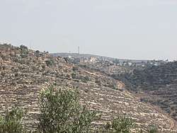
Qaryut
| Qaryout | |
|---|---|
| Other transcription(s) | |
| • Arabic | قريوت |
| • Also spelled |
Qaryout (official) Karyut, Kuriyet, Krayot (unofficial) |
 Qaryout | |
 Qaryout Location of Qaryout within Palestine | |
| Coordinates: 32°04′15″N 35°17′38″E / 32.07083°N 35.29389°ECoordinates: 32°04′15″N 35°17′38″E / 32.07083°N 35.29389°E | |
| Palestine grid | 178/164 |
| Governorate | Nablus |
| Government | |
| • Type | Village council |
| Population (2006) | |
| • Jurisdiction | 2,469 |
| Name meaning | The towns[1] |
Qaryout (Arabic: قريوت) is a Palestinian village of nearly 2,500 in the Nablus Governorate in the northern West Bank, located 28 kilometers (17 mi) southeast of Nablus.
According to the Palestinian Central Bureau of Statistics (PCBS), Qaryut had a population of 2,469 inhabitants in mid-year 2006.[2]
Location
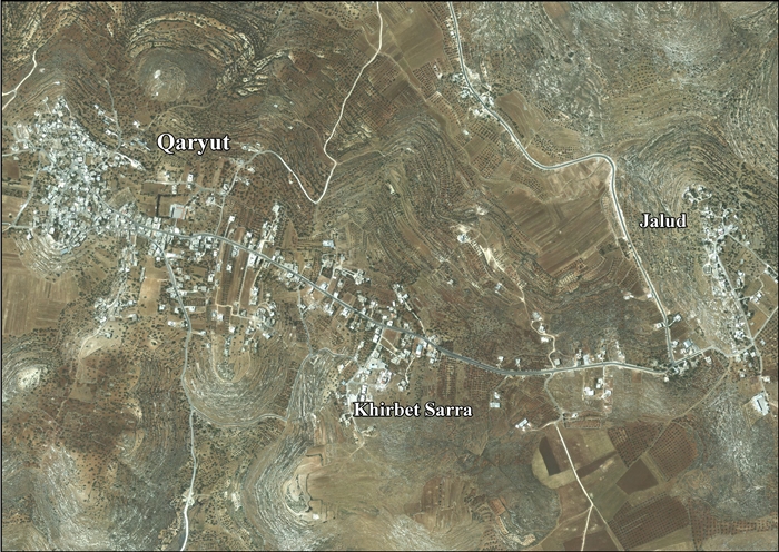
Qaryat is located 17 km south of Nablus. It is bordered by Duma and Jalud to the east, Qusra and Talfit to the north, As Sawiya to the west, and Turmus'ayya to the south.[3]
History
Shards from the Iron Age II, Persian, Persian/Hellenistic, Roman, Byzantine Crusader/Ayyubid and Mamluk era have been found here.[4]
Western travellers, like Edward Robinson, have suggested that Qaryat might be identical to ancient Coreae.[5][6][7]
It has also been suggested that Qaryat is identical with Kariateri, a place mentioned in Crusader texts.[8]
It has been noted that: "This place, being at the head of Wady Fusail, seems to have given rise to the mediaeval identification of that valley as the Brook Cherith (mentioned by Marino Sanuto in 1321)."[7]
Ottoman era
Potsherds from the early Ottoman era have been found here.[4]
In 1838, Kuriyet was noted as being located in El-Beitawy district, east of Nablus.[9][5]
In 1870, Victor Guérin noted: "This village is divided into two distinct districts, each under the jurisdiction of a particular Sheikh. Its population is seven hundred and fifty inhabitants. In the gardens around it grow fig trees, pomegranates and vines. Several old rock formations are currently dry, and women are forced to fetch water as far as Ain Siloun. In two houses, I notice some blocks with boss cut." Guérin also identified Qaryat with ancient Coreae.[10]
In 1882, the Palestine Exploration Fund's Survey of Western Palestine noted that Kuriyut was: "a small village, on the top of a high chain, with a spring between it and the ruin of Seilun."[7]
British Mandate era
In the 1922 census of Palestine, conducted by the British Mandate authorities, Qariut had a population of 530 Muslims,[11] increasing in the 1931 census to 732; 3 Christians and 729 Muslims, in 156 houses.[12]
In the 1945 statistics Qaryut had a population of 930, all Muslims,[13] with 7,491 dunams of land, according to an official land and population survey.[14] Of this, 2,611 dunams were plantations and irrigable land, 2,803 were used for cereals,[15] while 63 dunams were built-up land.[16]
Jordanian era
In the wake of the 1948 Arab–Israeli War, and after the 1949 Armistice Agreements, Qaryut came under Jordanian rule.
The Jordanian census of 1961 found 1,163 inhabitants.[17]
1967, aftermath
After the Six-Day War in 1967, Qaryut has been under Israeli occupation along with the rest of the Palestinian territories.
After the 1995 accords, 23% of village land is classified as Area B land, while the remaining 77% is Area C.[18]
As of 2014, Israel has confiscated 2,221 dunams of Qaryat village land for 3 Israeli settlements: Alie, Shilo and Mizpe Rahel.[19]
Israeli settlers from Alie have been blamed for uprooting more than 100 olive trees belonging to Qaryat village.[20]
Notable people
- Taysir Khalid (born 1941), Palestinian politician
References
- ↑ Palmer, 1881, p. 238
- ↑ Projected Mid -Year Population for Nablus Governorate by Locality 2004- 2006 Palestinian Central Bureau of Statistics
- ↑ Qaryut Village profile (including Jalud Locality), ARIJ, p. 4
- 1 2 Finkelstein et al, 1997, p. 654
- 1 2 Robinson and Smith, 1841, vol 3, p. 83
- ↑ Ritter, 1866, vol 2, p. 345
- 1 2 3 Conder and Kitchener, 1882, SWP II, p. 288
- ↑ Röhricht, 1887, p. 222; cited in Finkelstein et al, 1997, p. 654
- ↑ Robinson and Smith, 1841, vol 3, Appendix 2, p. 128
- ↑ Guérin, 1875, pp. 20-21
- ↑ Barron, 1923, Table IX, Sub-district of Nablus, p. 25
- ↑ Mills, 1932, p. 64
- ↑ Government of Palestine, Department of Statistics, 1945, p. 19
- ↑ Government of Palestine, Department of Statistics. Village Statistics, April, 1945. Quoted in Hadawi, 1970, p. 60
- ↑ Government of Palestine, Department of Statistics. Village Statistics, April, 1945. Quoted in Hadawi, 1970, p. 107
- ↑ Government of Palestine, Department of Statistics. Village Statistics, April, 1945. Quoted in Hadawi, 1970, p. 157
- ↑ Government of Jordan, Department of Statistics, 1964, p. 26
- ↑ Qaryut Village profile (including Jalud Locality), ARIJ, p. 16
- ↑ Qaryut Village profile (including Jalud Locality), ARIJ, p. 17
- ↑ More than 100 olive trees uprooted in West Bank, Palestinians report by Jack Khoury, Oct. 19, 2013, Haaretz
Bibliography
- Barron, J.B., ed. (1923). Palestine: Report and General Abstracts of the Census of 1922. Government of Palestine.
- Conder, C.R.; Kitchener, H.H. (1882). The Survey of Western Palestine: Memoirs of the Topography, Orography, Hydrography, and Archaeology. 2. London: Committee of the Palestine Exploration Fund.
- Finkelstein, I.; Lederman, Zvi, eds. (1997). Highlands of many cultures. Tel Aviv: Institute of Archaeology of Tel Aviv University Publications Section. ISBN 965-440-007-3.
- Government of Jordan, Department of Statistics (1964). First Census of Population and Housing. Volume I: Final Tables; General Characteristics of the Population (PDF).
- Government of Palestine, Department of Statistics (1945). Village Statistics, April, 1945.
- Guérin, V. (1875). Description Géographique Historique et Archéologique de la Palestine (in French). 2: Samarie, pt. 2. Paris: L'Imprimerie Nationale.
- Hadawi, S. (1970). Village Statistics of 1945: A Classification of Land and Area ownership in Palestine. Palestine Liberation Organization Research Center.
- Mills, E., ed. (1932). Census of Palestine 1931. Population of Villages, Towns and Administrative Areas. Jerusalem: Government of Palestine.
- Palmer, E.H. (1881). The Survey of Western Palestine: Arabic and English Name Lists Collected During the Survey by Lieutenants Conder and Kitchener, R. E. Transliterated and Explained by E.H. Palmer. Committee of the Palestine Exploration Fund.
- Ritter, C. (1886). The Comparative Geography of Palestine and the Sinaitic Peninsula. 2. T. & T. Clark.
- Robinson, E.; Smith, E. (1841). Biblical Researches in Palestine, Mount Sinai and Arabia Petraea: A Journal of Travels in the year 1838. 3. Boston: Crocker & Brewster.
- Röhricht, R. (1887). "Studien zur mittelalterlichen Geographie und Topographie Syriens". Zeitschrift des Deutschen Palästina-Vereins. 10: 195–344.
External links
- Welcome To Qaryut
- Survey of Western Palestine, Map 14: IAA, Wikimedia commons
- Qaryut Village profile (including Jalud Locality), Applied Research Institute–Jerusalem (ARIJ)
- Qaryut, aerial photo, ARIJ
- Development Priorities and Needs in Qaryut, ARIJ
