al-Badhan
| al-Badhan | |
|---|---|
| Other transcription(s) | |
| • Arabic | الباذان |
| • Also spelled |
al-Badhan (official) al-Badan (unofficial) |
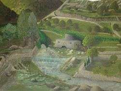 Painting of Badhan | |
 al-Badhan Location of al-Badhan within Palestine | |
| Coordinates: 32°15′42″N 35°19′41″E / 32.26167°N 35.32806°ECoordinates: 32°15′42″N 35°19′41″E / 32.26167°N 35.32806°E | |
| Palestine grid | 180/185 |
| Governorate | Nablus |
| Government | |
| • Type | Village council |
| Population (2006) | |
| • Jurisdiction | 2,422 |
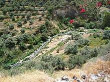
al-Badhan (Arabic: الباذان) is a Palestinian village in the Nablus Governorate in the North central West Bank, located 7.28 kilometres (4.52 mi) northeast of Nablus, and 1.5 kilometres (0.93 mi) to the north of Elon Moreh. According to the Palestinian Central Bureau of Statistics (PCBS), the village had a population of 2,422 inhabitants in mid-year 2006.[1] The adjacent valley, Wadi al-Badhan (also known as Wadi Sajour), is a picturesque natural area located 5 km northeast of Nablus on the road leading to the Jordan Valley. The area is characterized by abundant springs and diversity of wildlife. The area is one of the most beautiful natural areas in the West Bank and has a nature reserve to preserve wildlife.
History
Scholars today hold that al-Badhan is to be identified with the Badan (Hebrew: בדן; באדן) citied in the 2nd-century CE Mishnah and Tosefta, said to be a place then settled by Samaritans and renowned for its pomegranates.[2][3][4][5] The place features prominently in Samaritan tradition.[6][7] The village has several sites of archaeological interest including 12 ancient watermills. Victor Guérin passed through the region in 1870, where he described its geographical features.[8]
Jordanian era
In the wake of the 1948 Arab–Israeli War, and after the 1949 Armistice Agreements, Badhan came under Jordanian rule.
The Jordanian census of 1961 found 446 inhabitants.[9]
1967, aftermath
After the Six-Day War in 1967, al-Badhan has been under Israeli occupation. Under the interim Oslo Peace Accords, areas of the West Bank, which Israel conquered in the 1967 Mideast war, were divided into various categories. According to ARIJ, the village land is divided into 30% Area A, while the remaining 70% is defined as Area B.[10][11]
Since 2003, al-Badhan has been governed by a Village Council which is currently administrated by 10 members appointed by the Palestinian National Authority (PNA).
References
| Wikimedia Commons has media related to Wadi al-Badhan. |
- ↑ Projected Mid -Year Population for Nablus Governorate by Locality 2004- 2006 Archived 2008-02-07 at the Wayback Machine. Palestinian Central Bureau of Statistics
- ↑ Yoel Elitzur, Ancient toponyms in the land of Israel: preservation and history (2nd edition), Jerusalem 2012, p. 350 (Hebrew) ISBN 965-481-034-4
- ↑ Shimon Dar & Ze'ev Safrai, Shomron Studies, An Anthology of Researches (Heb. title: מחקרי שומרון: קובץ מחקרים), Hakkibbutz Hameuchad Publishing House: Tel-Aviv 1986, p. 148 (Hebrew)
- ↑ Zohar Amar, Flora and Fauna in Maimonides' Teachings, Kefar Darom 2015, p. 152, note 797 (Hebrew), where he writes: "[The pomegranates of Badan], see Maimonides' commentary on the Mishnah (Orlah 3:7) where Maimonides points out that it refers to a place inhabited by 'Samaritans' (Maimonides' commentary on the Mishnah, Kelim 17:5). Its identification has, in fact, been brought down in the Tosefta, Kelim - Baba Metzia 6:10. That is, Badan is to be identified in the area settled by the Samaritans during the period of the Sages. It is commonly accepted to identify the settlement of Badan as being near Wadi Bidan, to the northeast of Shechem (Nablus), a place flowing with running springs of water, emptying into the brook of Tirzah." OCLC 783455868
- ↑ The Mishnah, Herbert Danby (ed.), Oxford University Press: London 1977, s.v. Orlah 3:7, p.92 (note 9)
- ↑ Conder and Kitchener, 1882, SWP II, p. 231
- ↑ The Asatir (ed. Moses Gaster), The Royal Asiatic Society: London 1927, p. 210.
- ↑ Victor Guérin, Description géographique, historique et archéologique de la Palestine (Seconde Partie - Samarie), vol. 4, Paris 1874, p. 365.
- ↑ Government of Jordan, Department of Statistics, 1964, p. 25
- ↑ The Palestinian Locality Profiles
- ↑ Al Badhan Village profile, ARIJ, p. 17
Bibliography
- Conder, C.R.; Kitchener, H.H. (1882). The Survey of Western Palestine: Memoirs of the Topography, Orography, Hydrography, and Archaeology. 2. London: Committee of the Palestine Exploration Fund.
- Government of Jordan, Department of Statistics (1964). First Census of Population and Housing. Volume I: Final Tables; General Characteristics of the Population (PDF).
- Guérin, V. (1874). Description Géographique Historique et Archéologique de la Palestine (in French). 2: Samarie, pt. 1. Paris: L'Imprimerie Nationale.
- Palmer, E.H. (1881). The Survey of Western Palestine: Arabic and English Name Lists Collected During the Survey by Lieutenants Conder and Kitchener, R. E. Transliterated and Explained by E.H. Palmer. Committee of the Palestine Exploration Fund.
External links
- Welcome To al-Badan
- Wadi al-Badan, Welcome to Palestine
- Survey of Western Palestine, Map 12: IAA, Wikimedia commons
- Al Badhan Village profile, Applied Research Institute–Jerusalem (ARIJ)
- Al Badhan, aerial photo, ARIJ
- Development Priorities and Needs in Al Badhan, ARIJ
