Urif
| ’Urif | |
|---|---|
| Other transcription(s) | |
| • Arabic | عوريف |
| • Also spelled | Orif[1] (unofficial) |
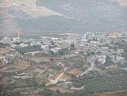 | |
 ’Urif Location of ’Urif within Palestine | |
| Coordinates: 32°09′34″N 35°13′23″E / 32.15944°N 35.22306°ECoordinates: 32°09′34″N 35°13′23″E / 32.15944°N 35.22306°E | |
| Palestine grid | 171/174 |
| Governorate | Nablus |
| Government | |
| • Type | Village council |
| Population (2006) | |
| • Jurisdiction | 2,839 |
| Name meaning | from personal name[2] |
Urif (Arabic: عوريف) is a Palestinian village in the Nablus Governorate in northern West Bank, located 13 kilometers (8 miles) south of Nablus. According to the Palestinian Central Bureau of Statistics (PCBS), the town had a population of 2,839 inhabitants in mid-year 2006.[3]
Location
‘Urif is located 7.6km south of Nablus. It is bordered by ‘Einabus to the east, ‘Asira al Qibliya to the north, and Jamma’in to the west and south.[4]
History
Ceramics from the late Roman have been found here.[5] Dauphin writes that ceramics from the Byzantine era also have been found,[5] but Ellenblum writes that no pottery from that era has been found here.[6]
Diya al-Din (1173-1245) refers to the presence of Muslims in Urif during his lifetime.[7]
Ottoman era
Urif was incorporated into the Ottoman Empire in 1517 with all of Palestine, and in 1596 it appeared in the tax registers as being in the Nahiya of Jabal Qubal of the Liwa of Nablus. It was noted as hali, empty, but a fixed tax rate of 33,3% was paid on various agricultural products, such as wheat, barley, summer crops, olive trees, goats and/or beehives, in addition to "occasional revenues"; a total of 2,800 akçe.[8]
In 1838 Urif was noted as a Muslim village, part of Jurat Merda, located south of Nablus.[9]
In 1870, Victor Guérin found the village to occupy the top of a hill, and having about 450 inhabitants.[10]
In 1882, the Palestine Exploration Fund's Survey of Western Palestine (SWP) described Urif as: "A stone village, on high ground, with a few olives; supplied by wells and with a small spring to the east."[11]
British Mandate era
In the 1922 census of Palestine conducted by the British Mandate authorities, Urif had a population of 270 Muslims,[12] increasing in the 1931 census to 403; 402 Muslims and 1 Christian, in 103 houses.[13]
In the 1945 statistics the population was 520, all Muslims,[14] while the total land area was 3,965 dunams, according to an official land and population survey.[15] Of this, 1,107 dunams were for plantations and irrigable land, 1,452 for cereals,[16] while 32 dunams were classified as built-up areas.[17]
Jordanian era
In the wake of the 1948 Arab–Israeli War, and after the 1949 Armistice Agreements, Urif came under Jordanian rule.
The Jordanian census of 1961 found 710 inhabitants.[18]
Post 1967
After the Six-Day War in 1967, Urif came under Israeli occupation. As of 2014, 3,115 dunams (77%) of Urif land were Area B, while 949 (23%) were Area C. 58 dunums of Uris land have been confiscated for the Israeli settlement of Yitzhar.[19]
Chronology of events and disturbances
- On May 19, 2012, about 25 Jewish settlers, some of them carrying guns, set fire to the wheat fields of Urif, and shot one Palestinian man in the stomach.[20]
- On May 26, 2012, settlers from Yitzhar shot a youth from Urif. They then tied him up and proceeded to beat him.[21] Samaria Regional Council head Gershon Mesika said that the shooting was a defensive act against a man who wielded a knife.[22] The clash had started when a group of settlers were thought to have set fire to fields belonging to Urif, although the settlers denied any involvement.[22]
- In 2013, settlers from Yitzhar reportedly smashed the window of a mosque in Urif and tried to burn it down.[23][24][25]
- In February, 2015, settlers from Yitzhar defaced the village school with graffiti, with 'Death to Arabs' sprayed alongside the Star of David in an alleged price tag attacks.[1]
- In July 2016, the IDF confiscated in Urif homemade weapons and ammunition, and lathes used to manufacture weapons, as well as apprehending four local Arab residents of Urif who sold such weapons.[26]
- In 2017, farmers from Urif were prevented from working on their land in Area B.[27][28]
References
- 1 2 Palestinian official: Jewish settlers deface West Bank school, February 26, 2015, Haaretz
- ↑ Palmer, 1881, p. 246
- ↑ Projected Mid -Year Population for Nablus Governorate by Locality 2004- 2006 Palestinian Central Bureau of Statistics
- ↑ ‘Urif Village Profile, ARIJ, p. 4
- 1 2 Dauphin, 1998, p. 803
- ↑ Ellenblum, 2003, p. 263
- ↑ Ellenblum, 2003, p. 244
- ↑ Hütteroth and Abdulfattah, 1977, p. 130
- ↑ Robinson and Smith, 1841, vol 3, Appendix 2, p. 127
- ↑ Guérin, 1875, p. 177
- ↑ Conder and Kitchener, 1881, SWP II, p. 287
- ↑ Barron, 1923, Table IX, p. 25
- ↑ Mills, 1932, p. 66
- ↑ Government of Palestine, Department of Statistics, 1945, p. 19
- ↑ Government of Palestine, Department of Statistics. Village Statistics, April, 1945. Quoted in Hadawi, 1970, p. 61
- ↑ Government of Palestine, Department of Statistics. Village Statistics, April, 1945. Quoted in Hadawi, 1970, p. 108
- ↑ Government of Palestine, Department of Statistics. Village Statistics, April, 1945. Quoted in Hadawi, 1970, p. 158
- ↑ Government of Jordan, Department of Statistics, 1964, p. 25
- ↑ ‘Urif Village Profile, ARIJ, 2014, p. 15
- ↑ Israeli Settler Shoots Palestinian in West Bank, May 26, 2012, Haaretz
- ↑ IDF Inquiry Finds Israeli Youth Tied and Beat Palestinian After Shot by Settlers, June 3, 2012, Haaretz
- 1 2 Lazaroff, Tovah (29 May 2012). "Palestinian, settler violence caught on tape again". The Jerusalem Post. Retrieved 9 April 2017.
- ↑ Kalman, Matthew (30 April 2013). "Israelis burn Palestinian fields and stone vehicles in West Bank after father is stabbed to death at settlement bus stop". The Independent. Retrieved 9 April 2017.
- ↑ Levinson, Chaim (30 April 2013). "Israeli settlers riot after West Bank terror attack, 6 arrested". Haaretz. Retrieved 9 April 2017.
- ↑ "Video footage shows the army failed in its duty to protect Palestinians from settler revenge attacks". B'Tselem. 2 May 2013. Retrieved 9 April 2017.
- ↑ http://www.mako.co.il/news-military/security-q3_2016/Article-d5b53b52108d551004.htm
- ↑ Twice barred Palestinian farmer says he will wait for IDF permission, April 2, 2017, Jerusalem Post
- ↑ In the West Bank, the tail wags the dog. When civilian security officers are dictating policy on the ground, to whom should Palestinian farmers in Urif turn?, April 2, 2017, Amira Hass, Haaretz
Bibliography
- Barron, J.B., ed. (1923). Palestine: Report and General Abstracts of the Census of 1922. Government of Palestine.
- Conder, C.R.; Kitchener, H.H. (1882). The Survey of Western Palestine: Memoirs of the Topography, Orography, Hydrography, and Archaeology. 2. London: Committee of the Palestine Exploration Fund.
- Dauphin, Claudine (1998). La Palestine byzantine, Peuplement et Populations. BAR International Series 726 (in French). III : Catalogue. Oxford: Archeopress. ISBN 0-860549-05-4.
- Ellenblum, Ronnie (2003). Frankish Rural Settlement in the Latin Kingdom of Jerusalem. Cambridge University Press. ISBN 9780521521871.
- Government of Jordan, Department of Statistics (1964). First Census of Population and Housing. Volume I: Final Tables; General Characteristics of the Population (PDF).
- Government of Palestine, Department of Statistics (1945). Village Statistics, April, 1945.
- Guérin, V. (1875). Description Géographique Historique et Archéologique de la Palestine (in French). 2: Samarie, pt. 2. Paris: L'Imprimerie Nationale.
- Hadawi, S. (1970). Village Statistics of 1945: A Classification of Land and Area ownership in Palestine. Palestine Liberation Organization Research Center.
- Hütteroth, Wolf-Dieter; Abdulfattah, Kamal (1977). Historical Geography of Palestine, Transjordan and Southern Syria in the Late 16th Century. Erlanger Geographische Arbeiten, Sonderband 5. Erlangen, Germany: Vorstand der Fränkischen Geographischen Gesellschaft. ISBN 3-920405-41-2.
- Mills, E., ed. (1932). Census of Palestine 1931. Population of Villages, Towns and Administrative Areas. Jerusalem: Government of Palestine.
- Palmer, E.H. (1881). The Survey of Western Palestine: Arabic and English Name Lists Collected During the Survey by Lieutenants Conder and Kitchener, R. E. Transliterated and Explained by E.H. Palmer. Committee of the Palestine Exploration Fund.
- Robinson, E.; Smith, E. (1841). Biblical Researches in Palestine, Mount Sinai and Arabia Petraea: A Journal of Travels in the year 1838. 3. Boston: Crocker & Brewster.
External links
- Welcome To 'Urif
- Urif
- Survey of Western Palestine, Map 14: IAA, Wikimedia commons
- ‘Urif Village Profile, Applied Research Institute–Jerusalem (ARIJ)
- Development Priorities and Needs in ‘Urif, ARIJ
- Setting 22 Dunums of Agricultural Lands Ablaze in Urif village -Nablus Governorate, POICA, April 30, 2013
