Furush Beit Dajan
| Furush Beit Dajan | |
|---|---|
| Other transcription(s) | |
| • Arabic | فروش بيت دجن |
| • Also spelled |
Froush Beit Dajan (official) Furush Bayt Dajan (unofficial) |
 Furush Beit Dajan Location of Furush Beit Dajan within Palestine | |
| Coordinates: 32°12′25″N 35°26′38″E / 32.20694°N 35.44389°ECoordinates: 32°12′25″N 35°26′38″E / 32.20694°N 35.44389°E | |
| Palestine grid | 191/179 |
| Governorate | Nablus |
| Government | |
| • Type | Village council |
| Population (2006) | |
| • Jurisdiction | 1,160 |
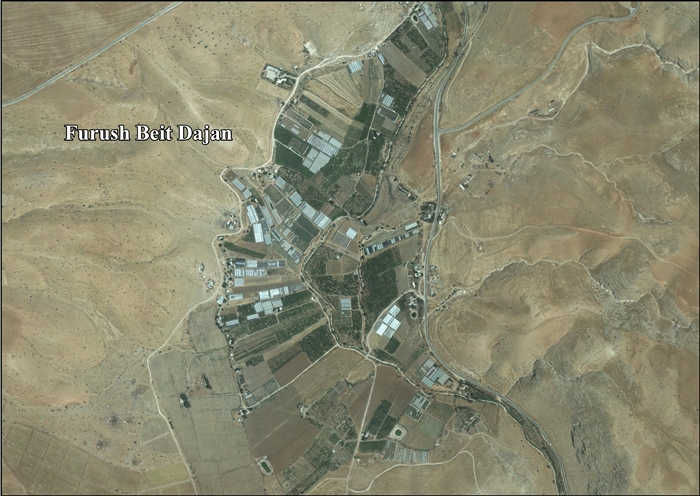
Furush Beit Dajan (Arabic: فروش بيت دجن) is a Palestinian village in the northern West Bank, located 10 kilometers east of Nablus and a part of the Nablus Governorate. According to the Palestinian Central Bureau of Statistics, the village had a population of approximately 1,160 inhabitants in 2006.[1]
Most of Furush Beit Dajan's residents are Bedouins or descendants of Bedouins who migrated from the village of Yattir in the Negev desert after being evicted by Israeli authorities in 1952. Most have abandoned their nomadic lifestyle and have adapted to farming. However, many still herd sheep and goats to the north of the village where there is a natural grazing area. Furush Beit Dajan receives most of its water from springs in the southern part of the village.[2]
References
- ↑ Projected Mid -Year Population for Nablus Governorate by Locality 2004- 2006 Archived February 7, 2008, at the Wayback Machine. Palestinian Central Bureau of Statistics
- ↑ Eviction of the Inhabitants of Froush Beit Dajan Applied Research Institute - Jerusalem. 3 May 1997.
External links
- Survey of Western Palestine, Map 12: IAA, Wikimedia commons
- Furush Beit Dajan Village profile, Applied Research Institute - Jerusalem (ARIJ)
- Furush Beit Dajan, aerial photo, ARIJ
- Development Priorities and Needs in Furush Beit Dajan, ARIJ
