An-Naqura
| An Naqura | |
|---|---|
| Other transcription(s) | |
| • Arabic | الناقوره |
| • Also spelled |
an-Naqoura (official) al-Nakura (unofficial) |
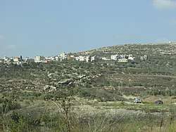 Houses in south An-Naqura. Up on the hill on the right is Ibrahim al-Adham Sheikh tomb. | |
 An Naqura Location of An Naqura within Palestine | |
| Coordinates: 32°15′56″N 35°12′05″E / 32.26556°N 35.20139°ECoordinates: 32°15′56″N 35°12′05″E / 32.26556°N 35.20139°E | |
| Palestine grid | 169/185 |
| Governorate | Nablus |
| Government | |
| • Type | Village council |
| • Head of Municipality | Muhammad Hashish |
| Population (2007) | |
| • Jurisdiction | 1,545 |
| Name meaning | En Nakurah: the horn or trumpet[1] |
An-Naqura (Arabic: الناقوره, also spelled al-Nakura) is a Palestinian village in the Nablus Governorate in northern West Bank, located 10 kilometers northwest of Nablus and adjacent to the Israeli settlement of Shavei Shomron. According to the Palestinian Central Bureau of Statistics (PCBS) census, the village had a population of 1,545 in 2007.[2] An-Naqura is administered by a ten-member village council headed by Muhammad Hashish.[3]
Location
An Naqura is located 7.57 km northwest of Nablus. It is bordered by Zawata to the east, Ijnisinya to the east and north, Sabastiya to the north, Deir Sharaf to the west and south, and Beit Iba to the south.[4]
History
Pottery sherds from the Early Bronze I, Iron Age II, late Roman, Byzantine, early Muslim and Medieval eras have been found here.[5]
Ottoman era
It has been suggested that An-Naqura was the village named Aqbara or Aquira, in the 1596 Ottoman tax records. It had 23 households and 5 bachelors, all Muslim.[6]
In 1667, Anthimus mentions a Christian population in this village, though it had no church.[7]
In 1838 Robinson noted the village as en-Nakurah in the Wady esh-Sha'ir district, west of Nablus.[8][9]
In 1870, Victor Guérin noted it as a village on a hill, with 300 inhabitants, where ancient stones were used in the house-walls.[10]
In 1882, the Palestine Exploration Fund's Survey of Western Palestine (SWP) described En Nakurah: "A small stone village on the slope of the hill. It has olives, which appear to grow half wild, and a spring of good water, apparently perennial, in the valley to the north, near which are vegetable gardens. A small Mukam stands above the village, on the south."[11]
British Mandate era
In the 1922 census of Palestine conducted by the British Mandate authorities, Nakura had a population of 233 Muslims,[12] increasing in the 1931 census to 247, still all Muslims, in a total of 69 houses.[13]
In the 1945 statistics En Naqura had a population of 350 Muslims[14] and a total of 5,507 dunams of land, according to an official land and population survey.[15] Of this, 591 dunams were plantations and irrigable land, 3,444 were used for cereals,[16] while 27 dunams were built-up land.[17]
Jordanian era
In the wake of the 1948 Arab–Israeli War, and after the 1949 Armistice Agreements, An-Naqura came under Jordanian rule.
The Jordanian census of 1961 found 487 inhabitants.[18]
Post-1967
After the Six-Day War in 1967, An-Naqura has been under Israeli occupation, and the same year the population was recorded as 610, of whom 37 were refugees from Israel.[19]
According to ARIJ, 14% of village land is in Area A, 51% of the village land is in Area B, while the remaining 35% is in Area C. Israel has confiscated 680 dunums of village land for the Israeli settlement of Shavei Shomron.[20]
References
- ↑ Palmer, 1881, p. 188
- ↑ 2007 PCBS Census. Palestinian Central Bureau of Statistics. p. 108.
- ↑ Naqura Profile. Jerusalem Media and Communications Center (JMCC).
- ↑ An Naqura Village profile, ARIJ, p. 4
- ↑ Zertal, 2004, p. 478
- ↑ Hütteroth and Abdulfattah, 1977, p. 127; cited in Zertal, 2004, p. 478
- ↑ Ellenblum, 2003, p. 248
- ↑ Robinson and Smith, 1841, vol 3, Appendix 2, p. 129
- ↑ Robinson and Smith, 1841, vol 3, p.138
- ↑ Guérin, 1875, p. 186
- ↑ Conder and Kitchener, 1882, SWP II, p. 160
- ↑ Barron, 1923, Table IX, Sub-district of Nablus, p. 24
- ↑ Mills, 1932, p. 63
- ↑ Government of Palestine, Department of Statistics, 1945, p. 19
- ↑ Government of Palestine, Department of Statistics. Village Statistics, April, 1945. Quoted in Hadawi, 1970, p. 60
- ↑ Government of Palestine, Department of Statistics. Village Statistics, April, 1945. Quoted in Hadawi, 1970, p. 107
- ↑ Government of Palestine, Department of Statistics. Village Statistics, April, 1945. Quoted in Hadawi, 1970, p. 157
- ↑ Government of Jordan, Department of Statistics, 1964, p. 26
- ↑ Perlmann, Vol 1, Tab 2: Naqura.
- ↑ An Naqura Village profile, ARIJ, p. 15
Bibliography
- Barron, J.B., ed. (1923). Palestine: Report and General Abstracts of the Census of 1922. Government of Palestine.
- Conder, C.R.; Kitchener, H.H. (1882). The Survey of Western Palestine: Memoirs of the Topography, Orography, Hydrography, and Archaeology. 2. London: Committee of the Palestine Exploration Fund.
- Crowfoot, J.W.; Kenyon, K.M.; Sukenik, E.L. (1942). The Buildings at Samaria (Samaria-Sebaste, I). London: Palestine Exploraton Fund. pp. 79–81.
- Ellenblum, Ronnie (2003). Frankish Rural Settlement in the Latin Kingdom of Jerusalem. Cambridge University Press. ISBN 9780521521871.
- Government of Jordan, Department of Statistics (1964). First Census of Population and Housing. Volume I: Final Tables; General Characteristics of the Population (PDF).
- Government of Palestine, Department of Statistics (1945). Village Statistics, April, 1945.
- Guérin, V. (1875). Description Géographique Historique et Archéologique de la Palestine (in French). 2: Samarie, pt. 2. Paris: L'Imprimerie Nationale.
- Hadawi, S. (1970). Village Statistics of 1945: A Classification of Land and Area ownership in Palestine. Palestine Liberation Organization Research Center.
- Hütteroth, Wolf-Dieter; Abdulfattah, Kamal (1977). Historical Geography of Palestine, Transjordan and Southern Syria in the Late 16th Century. Erlanger Geographische Arbeiten, Sonderband 5. Erlangen, Germany: Vorstand der Fränkischen Geographischen Gesellschaft. ISBN 3-920405-41-2.
- Mills, E., ed. (1932). Census of Palestine 1931. Population of Villages, Towns and Administrative Areas. Jerusalem: Government of Palestine.
- Palmer, E.H. (1881). The Survey of Western Palestine: Arabic and English Name Lists Collected During the Survey by Lieutenants Conder and Kitchener, R. E. Transliterated and Explained by E.H. Palmer. Committee of the Palestine Exploration Fund.
- Perlmann, Joel: The 1967 Census of the West Bank and Gaza Strip: A Digitized Version. Annandale-on-Hudson, N.Y.: Levy Economics Institute of Bard College. November 2011 – February 2012. [Digitized from: Israel Central Bureau of Statistics, Census of Population and Housing, 1967 Conducted in the Areas Administered by the IDF, Vols. 1–5 (1967–70), and Census of Population and Housing: East Jerusalem, Parts 1 and 2 (1968–70).]
- Robinson, E.; Smith, E. (1841). Biblical Researches in Palestine, Mount Sinai and Arabia Petraea: A Journal of Travels in the year 1838. 3. Boston: Crocker & Brewster.
- Zertal, A. (2004). The Manasseh Hill Country Survey. 1. Boston: BRILL. ISBN 9004137564.
External links
- Welcome To al-Naqura
- Survey of Western Palestine, Map 11: IAA, Wikimedia commons
- An Naqura Village profile, Applied Research Institute–Jerusalem (ARIJ)
- al-Naqura, aerial photo, ARIJ
- Development Priorities and Needs in An Naqura, ARIJ
