Banias
|
بانياس الحولة בניאס | |
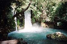
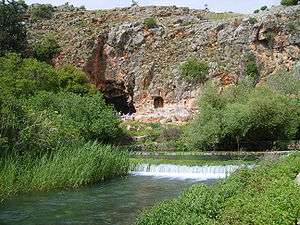 The spring of Banias with the Cave of Pan in background | |
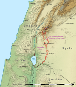 Shown within Golan Heights | |
| Location | Mount Hermon north of the Golan Heights |
|---|---|
| Coordinates | 33°14′55″N 35°41′40″E / 33.24861°N 35.69444°ECoordinates: 33°14′55″N 35°41′40″E / 33.24861°N 35.69444°E |
| Type |
the town of Caesarea Philippi with the sanctuary of Pan |
| History | |
| Cultures | Hellenistic, Roman, Byzantine, Early Islamic, Crusader |
| Site notes | |
| Archaeologists | Zvi Maoz (Area A, the temples area) and Vassilios Tzaferis (Area B, the central civic area)[1] |
| Public access | yes (national park) |
Banias (Arabic: بانياس الحولة; Hebrew: בניאס) is the Arabic and modern Hebrew name of an ancient site that developed around a spring once associated with the Greek god Pan. It is located at the foot of Mount Hermon, north of the Golan Heights. The spring is the source of the Banias River, one of the main tributaries of the Jordan River. Archaeologists uncovered a shrine dedicated to Pan and related deities, and the remains of an ancient city founded sometime after the conquest by Alexander the Great and inhabited until 1967; the ancient city was mentioned in the Gospels of Matthew and Mark by the name of Caesarea Philippi.
The first mention of the ancient city during the Hellenistic period was in the context of the Battle of Panium, fought around 200-198 BCE, when the name of the region was given as the Panion. Later, Pliny called the city Paneas (Greek: Πανειάς). Both names were derived from that of Pan, the god of the wild and companion of the nymphs.
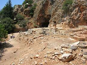
The spring at Banias initially originated in a large cave carved out of a sheer cliff face which was gradually lined with a series of shrines. The temenos (sacred precinct) included in its final phase a temple placed at the mouth of the cave, courtyards for rituals, and niches for statues. It was constructed on an elevated, 80m long natural terrace along the cliff which towered over the north of the city. A four-line inscription at the base of one of the niches relates to Pan and Echo, the mountain nymph, and was dated to 87 BCE.
The once very large spring gushed from the limestone cave, but an earthquake moved it to the foot of the natural terrace where it now seeps quietly from the bedrock, with a greatly reduced flow. From here the stream, called Nahal Hermon in Hebrew, flows towards what once were the malaria-infested Hula marshes.[2]
History
Semitic deity of the spring
The pre-Hellenistic deity associated with the spring of Banias was variously called Ba'al-gad or Ba'al-hermon.[3]
Hellenism; association with Pan

Banias was certainly an ancient place of great sanctity, and when Hellenised religious influences began to overlay the region, the cult of its local numen gave place to the worship of Pan, to whom the cave was therefore dedicated.[4]
Paneas was first settled in the Hellenistic period following Alexander the Great's conquest of the east. The Ptolemaic kings built a cult centre there in the 3rd century BC.
In the Hellenistic Period the spring was named Panias, for the Arcadian goat-footed god Pan. Pan was revered by the ancient Greeks as the god of isolated rural areas, music, goat herds, hunting, herding, of sexual and spiritual possession, and of victory in battle, since he was said to instill panic among the enemy.[5] The Latin equivalent for Paneas is Fanium.
The spring lies close to the 'way of the sea' mentioned by Isaiah,[6] along which many armies of Antiquity marched.
In extant sections of the Greek historian Polybius's history of 'The Rise of the Roman Empire', a Battle of Panium is mentioned. This battle was fought in ca. 200-198 BC between the armies of Ptolemaic Egypt and the Seleucids of Coele-Syria, led by Antiochus III.[7][8][9] Antiochus's victory cemented Seleucid control over Phoenicia, Galilee, Samaria, and Judea until the Maccabean revolt. It was these Seleucids who built a pagan temple dedicated to Pan at Paneas.[10]
Roman and Byzantine Periods
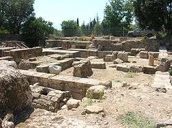
Upon Zenodorus's death in 20 BC, the Panion (Greek: Πανιάς), including Paneas, was annexed to the Kingdom of Herod the Great, a client of the Roman Empire.[11] Herod erected a temple of 'white marble' there in honour of his patron. In 3 BCE, Philip II (also known as Philip the Tetrarch) founded a city which became his administrative capital, known from Josephus[12] and the Gospels of Matthew and Mark as Caesarea or Caesarea Philippi, to distinguish it from Caesarea Maritima and other cities named Caesarea (Matthew 16:13, Mark 8:27). On the death of Philip II in 34 CE his kingdom was briefly incorporated into the province of Syria, with the city given the autonomy to administer its own revenues,[13] before reverting to his nephew, Herod Agrippa I.
In 61 CE, king Agrippa II renamed the administrative capital Neronias in honour of the Roman emperor Nero, but this name was discarded several years later, in 68 CE.[14] Agrippa also carried out urban improvements.[Note 1]
In 67CE, during the First Jewish–Roman War, Vespasian briefly visited Caesarea Philippi before advancing on Tiberias in Galilee.[16]
With the death of Agrippa II around the year 92 came the end of Herodian rule, and the city returned to the province of Syria.
In the late Roman and Byzantine periods the written sources name the city again as Paneas, or more seldomly as Caesarea Paneas.[17]
In 361, Emperor Julian the Apostate instigated a religious reformation of the Roman state,[18] in which he supported the restoration of Hellenic paganism as the state religion.[19] In Paneas this was achieved by replacing Christian symbols, though the change was short lived.
In the 5th century, following the division of the Empire, the city was part of the Eastern (later Byzantine) Empire, but was lost to the Arab expansion of the 7th century.
Arab dynasties of the Caliphate
In 635 Paneas gained favourable terms of surrender from the Muslim army of Khalid ibn al-Walid after it had defeated Heraclius' forces. In 636, a second, newly formed Byzantine army advancing on Palestine used Paneas as a staging post on the way to confront the Muslim army at the final Battle of Yarmouk.[20]
The depopulation of Paneas after the Muslim conquest was rapid, as its traditional markets disappeared. Only 14 of the 173 Byzantine sites in the area show signs of habitation from this period. The Hellenised city thus fell into a precipitous decline. At the council of al-Jabiyah, when the administration of the new territory of the Umar Caliphate was established, Paneas remained the principal city of the district of al-Djawlan (the Djawlan) in the jund (military Province) of Dimashq (Damascus), due to its strategic military importance on the border with Jund al-Urdunn, which comprised the Galilee and territories east and north of it.[21][22]
Around 780 CE the nun Hugeburc visited Caesarea and reported that the town 'had' a church and a great many Christians, but her account does not clarify whether any of those Christians were still living in the town at the time of her visit.[23]
The transfer of the Abbasid Caliphate capital from Damascus to Baghdad inaugurated the flowering of the Islamic Golden Age at the expense of the provinces.[24] With the decline of Abbasid power in the tenth century, Paneas found itself a provincial backwater in a slowly collapsing empire,[25] as district governors began to exert greater autonomy and used their increasing power to make their positions hereditary.[26] The control of Syria and Paneas passed to the Fatimids of Egypt.
At the end of the 9th century Al-Ya'qubi reaffirms that Paneas was still the capital of al-Djawlan in the jund of Dimshq, although by then the town was known as Madīnat al-Askat (city of the tribes) with its inhabitants being Qays, mostly of the Banu Murra with some Yamani families.[27]
Due to the Byzantine advances under Nicephorus Phocas and John Zimisces into the Abbasid empire, a wave of refugees fled south and augmented the population of Madīnat al-Askat. The city was taken over by an extreme Shī‘ah sect of the Bedouin Qarāmita in 968. In 970 the Fatimids again briefly took control, only to lose it again to the Qarāmita. The old population of Banias along with the new refugees formed a Sunni sufi ascetic community.[28] In 975 the Fatimid al-'Aziz wrested control in an attempt to subdue the anti-Fatimid agitation of Mahammad b. Ahmad al-Nablusi and his followers and to extend Fatimid control into Syria.[28] al-Nabulusi’s school of hadith was to survive in Banias under the tutelage of Arab scholars such as Abú Ishaq (Ibrahim b. Hatim) and al-Balluti.[29]
Crusader and Ayyubid period
The Crusaders' arrival in 1099 quickly split the mosaic of semi-independent cities of the Seljuk Kingdom of Damascus.[30]
The Crusaders have held the town twice, 1128–32 and 1140–64.[31]
Banias was pillaged by the crusaders in 1148.[32]
With the arrival of fresh troops to the Holy Land, King Baldwin broke the three-month-old truce of February 1157 by raiding the large flocks that the Turkomans had pastured in the area of Caesarea Philippi (Banias). In 1157 Banias became the principal centre of Humphrey of Toron's crusader fiefdom, along with his being the constable of the Kingdom of Jerusalem, after it had first been granted to the Hospitallers by King Baldwin. The Knights Hospitallers, having fallen into an ambush, relinquished the fiefdom.[33] Humphrey in turn was besieged in Banias and King Baldwin was able to break the siege, only to be ambushed at Jacob's Ford in June 1157. The fresh troops arriving from Antioch and Tripoli were able to relieve the besieged crusaders. Template:Missing words? within the Lordship of Beirut. It was captured by Nūr ed-Din on 18 November 1164.[32][34] The Franks had built a castle at Hunin (Château Neuf) in 1107 to protect the trade route from Damascus to Tyre. After Nūr ed-Din's ousting of the Crusader Humphrey of Toron from Banias, Hunin was at the front line securing the border defences against the Saracen garrison at Banias.[35]
Ibn Jubayr, the geographer, traveller and poet from al-Andalus, described Banias:
- This city is a frontier fortress of the Muslims. It is small, but has a castle, round which, under the walls flows a stream. This stream flows out from the town by one of the gates, and turns a mill ... The town has broad arable lands in the adjacent plain. Commanding the town is the fortress, still belonging to the Franks, called Hunin, which lies 3 leagues distant from Banias. The lands in the plain belong half to the Franks and half to the Muslims; and there is here the boundary called Hadd al Mukasimah-"the boundary of the dividing." The Muslims and the Franks apportion the crops equally between them, and their cattle mingle freely without fear of any being stolen.”
After the death of Nūr ed-Din in May 1174 King Amaury led the crusader forces in a siege of Banias. The Governor of Damascus allied himself with the crusaders and released all his Frankish prisoners. With the death of King Amaury in July 1174 the crusader border became unstable. In 1177 King Baldwin IV of Jerusalem ("the leper") laid siege to Banias and again the crusader forces withdrew after receiving tribute from Samsan al-Din Ajuk, the Governor of Banias.[36]
In 1179 al-Malik al-Nâsir Ṣalāḥ ad-Dīn Yūsuf ibn Ayyūb (Saladin) took personal control of the forces of Banias and created a protective screen across the Hula through Tell al-Qadi.[36]
In 1187 Saladin ordered al-Afdal (his son) to send an envoy to Count Raymond III of Tripoli requesting safe passage through his principality of Galilee and Tiberias. Raymond was obliged to grant the request under the terms of his treaty with Saladin. Al-Afdal's force of 7,000 horsemen left Banias and encountered a force of 150 Knights Templar led by Gerard de Ridefort, Grand Master of the Knights Templar. The Templar force was destroyed in the encounter. Saladin then besieged Tiberias, and after six days the town fell. On 4 July 1187 Saladin defeated the crusaders coming to relieve Tiberias at the Battle of Hattin.[37][38]
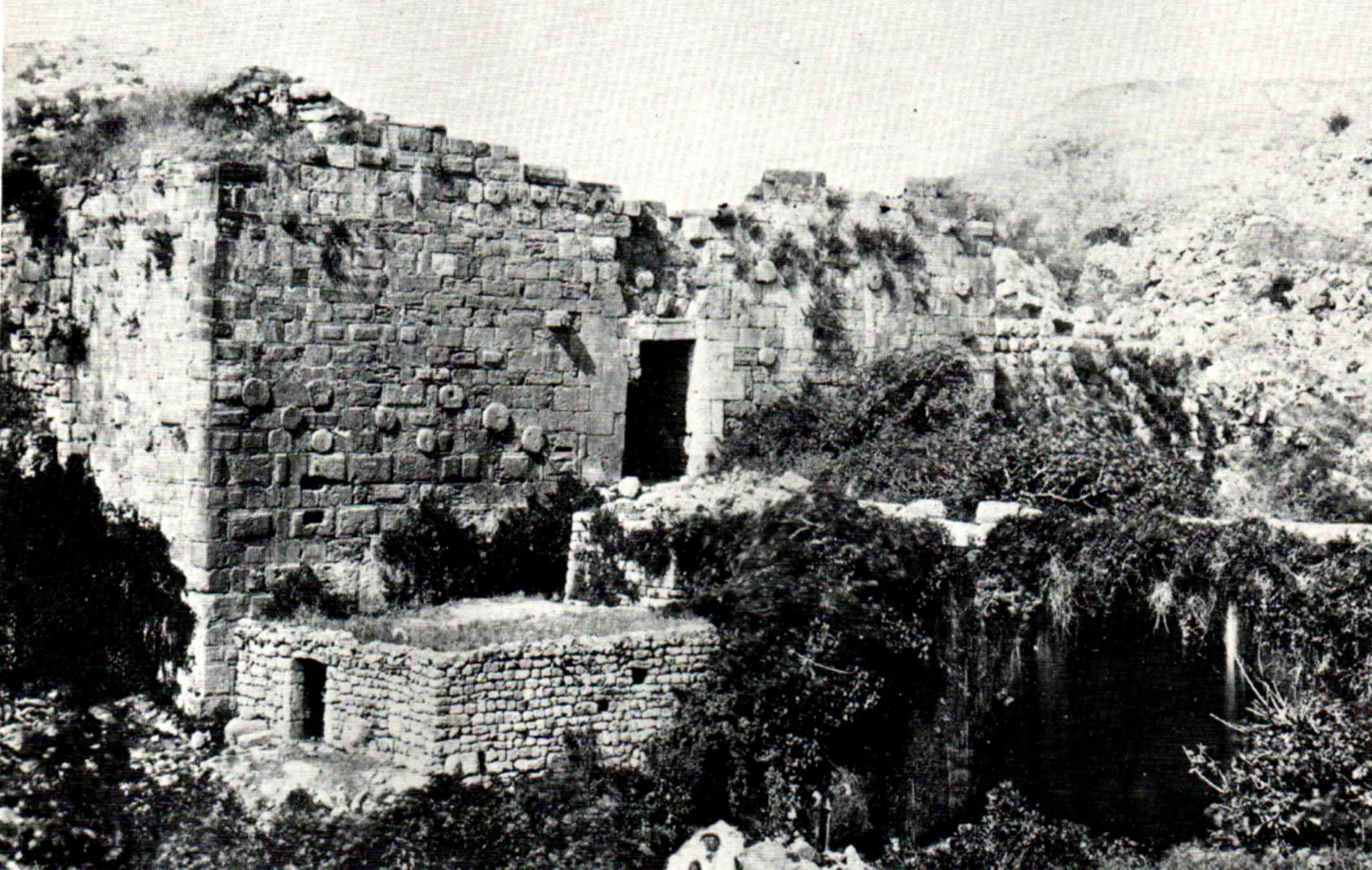
In the first decade of the thirteenth century Banias was partially destroyed by an earthquake. Jahârkas, the local amir, rebuilt the burj (fortress tower) in 1204 (AH 597),[39] named as Kŭl’at es-Subeibeh in 1846 by B B Edwards.[40][41]
In March 1219 Khutluba was forced to relinquish Banias and destroy its fortress. The city was then passed to al-'Adil and his son al-Mu'azzam.[39]
Banias along with Toron (now the modern town of Tebnine) and Safed were recovered by the Franks through treaty in 1229, just two years after al-Mu'azzam's death on November 11, 1227, by Frederick II from Sultan al-Kamil.
Ottoman period
The traveller J. S. Buckingham described Banias in 1825: "The present town is small, and meanly built, having no place of worship in it; and the inhabitants, who are about 500 in number, are Mohammedans and Metouali, governed by a Moslem Sheikh.[42]
In the 1870s, Banias was described as "a village, built of stone, containing about 350 Moslems, situated on a raised table-land at the bottom of the hills of Mount Hermon. The village is surrounded by gardens crowded with fruit-trees. The source of the Jordan is close by, and the water runs in little aqueducts into and under every part of the modern village."[43]
French Mandate to contemporary
The Syria-Lebanon-Palestine boundary was a product of the post-World War I Anglo-French partition of Ottoman Syria.[44][45] British forces had advanced to a position at Tel Hazor against Turkish troops in 1918 and wished to incorporate all the sources of the Jordan River within the British controlled Palestine. Due to the French inability to establish administrative control, the frontier between Syria and Palestine was fluid. Following the Paris Peace Conference of 1919, and the unratified and later annulled Treaty of Sèvres, stemming from the San Remo conference, the 1920 boundary extended the British controlled area to north of the Sykes Picot line, a straight line between the mid point of the Sea of Galilee and Nahariya. In 1920 the French managed to assert authority over the Arab nationalist movement and after the Battle of Maysalun, King Faisal was deposed.[46] The international boundary between Palestine and Syria was finally agreed by Great Britain and France in 1923 in conjunction with the Treaty of Lausanne, after Britain had been given a League of Nations mandate for Palestine in 1922.[47] Banyas (on the Quneitra/Tyre road) was within the French Mandate of Syria. The border was set 750 metres south of the spring.[45][48]
In 1941 Australian forces occupied Banias in the advance to the Litani during the Syria-Lebanon Campaign;[49] Free French and Indian forces also invaded Syria in the Battle of Kissoué.[50] Banias's fate in this period was left in a state of limbo since Syria had come under British military control. When Syria was granted independence in April 1946, it refused to recognize the 1923 boundary agreed between Britain and France.[Note 2]
Following the 1948 Arab Israeli War, the Banias spring remained in Syrian territory, while the Banias River flowed through the Demilitarized Zone (DMZ) into Israel. In 1953, at one of a series of meetings to regularize administration of the DMZs, Syria offered to adjust the armistice lines, and cede to Israel's 70% of the DMZ, in exchange for a return to the pre 1946 International border in the Jordan basin area, with Banias water resources returning to Syrian sovereignty. On 26 April, the Israeli cabinet met to consider the Syrian suggestions, with head of Israel’s Water Planning Authority, Simha Blass, in attendance. Blass noted that while the land to be ceded to Syria was not suitable for cultivation, the Syrian map did not suit Israel’s water development plan. Blass explained that the movement of the International boundary in the area of Banias would affect Israel’s water rights.[Note 3] The Israeli cabinet rejected the Syrian proposals but decided to continue the negotiations by making changes to the accord and placing conditions on the Syrian proposals. The Israeli conditions took into account Blass’s position over water rights and Syria rejected the Israeli counter offer.[52]
In September 1953, Israel advanced plans for its National Water Carrier to help irrigate the coastal Sharon Plain and eventually the Negev desert by launching a diversion project on a nine-mile (14 km) channel midway between the Huleh Marshes and Lake Galilee (Lake Tiberias) in the central DMZ to be rapidly constructed. This prompted shelling from Syria[53] and friction with the Eisenhower Administration; the diversion was moved to the southwest.
The Banias was included in the Jordan Valley Unified Water Plan, which allocated Syria 20 million cubic metres annually from it. The plan was rejected by the Arab League. Instead, at the 2nd Arab summit conference in Cairo of January 1964 the League decided that Syria, Lebanon and Jordan would begin a water diversion project. Syria started the construction of canal to divert the flow of the Banias river away from Israel and along the slopes of the Golan toward the Yarmouk River. Lebanon was to construct a canal from the Hasbani River to Banias and complete the scheme[54] The project was to divert 20 to 30 million cubic metres of water from the river Jordan tributaries to Syria and Jordan for the development of Syria and Jordan.[54][55] The diversion plan for the Banias called for a 73 kilometre long canal to be dug 350 metres above sea level, that would link the Banias with the Yarmuk. The canal would carry the Banias’s fixed flow plus the overflow from the Hasbani (including water from the Sarid and Wazani). This led to military intervention from Israel, first with tank fire and then, as the Syrians shifted the works further eastward, with airstrikes.
On June 10, 1967, the last day of the Six Day War, the Golani Brigade occupied the village of Banias. Eshkol's priority on the Syrian front was control of the water sources.[56]
Misidentification as biblical Laish/Dan
While Banias does not appear in the Old Testament, Philostorgius, Theodoret, Benjamin of Tudela and Samuel ben Samson all incorrectly identified it with Laish, now known to be located at Tell el-Qadi (Arabic) or Tel Dan (modern Hebrew).[39][57][58] Eusebius of Caesarea accurately places Dan/Laish in the vicinity of Paneas at the fourth mile on the route to Tyre.[58] Eusebius's identification was confirmed by E Robinson in 1838 and subsequently by archaeological excavations at Tel Dan and Caesarea Philippi.
Notables from Banias
- Al-Wadin ibn ‘Ata al-Dimashki (d. 764 or 766) - an Arab scholar of the Umayyad era
Further reading
Water issues
- Water for the Future: The West Bank and Gaza Strip, Israel, and Jordan By U.S. National Academy of Sciences, Inc NetLibrary, Jamʻīyah al-ʻIlmīyah al-Malakīyah, Committee on Sustainable Water Supplies for the Middle East, National Research Council, National Academy of Sciences (U.S.) Published by National Academies Press, 1999 ISBN 0-309-06421-X,
- Allan, John Anthony and Allan, Tony (2001) The Middle East Water Question: Hydropolitics and the Global Economy I.B.Tauris, ISBN 1-86064-813-4
- Amery, Hussein A. and Wolf, Aaron T. (2000) Water in the Middle East: A Geography of Peace University of Texas Press, ISBN 0-292-70495-X
See also
Notes
- ↑ 'As for Panium itself, its natural beauty had been improved by the royal liberality of Agrippa, and adorned at his expenses.'[15]
- ↑ "Syria claimed that France’s signature on the border agreement was invalid, but the British would not discuss the situation. A 'Demilitarised zone' was created at the three disputed points along the border, one of which was the territory around Banias, with Syria withdrawing troops, but continuing to lay claim to the territory within the zone. Thus from the beginning of the Syrian state to the Six Day War, there was no settled border."[51]
- ↑ At the eighth meeting on 13 April, the Syrian delegates seemed very anxious to move forward and offered Israel around 70% of the DMZ’s. Significant results were achieved and a number of suggestions and summaries put in writing, but they required decisions by the two governments. The Israeli cabinet convened on 26 April to consider the Syrian suggestions for the division of the DMZs. Simha Blass, head of Israel’s Water Planning Authority, was invited to the meeting. Dayan showed Blass the Syrian suggestions on the map. Blass told Dayan that although most of the lands that Israel was expected to relinquish were not suitable for cultivation, the map did not suit Israel’s irrigation and water development plans... Although phrased in a positive manner, this decision appears to have killed the negotiations. It involved changes to the preliminary accord and new conditions that made it difficult to go forward. At the last two meetings, on 4 and 27 May Israel presented its new conditions. These were rejected by Syria, and the negotiations ended without agreement.[52]
References
- ↑ Negev & Gibson (2001), pp. 382–383
- ↑ Wilson (2004), p. 2
- ↑ Bromiley, Geoffrey W. (1995) International Standard Bible Encyclopedia: A-D, Wm. B. Eerdmans Publishing, ISBN 0-8028-3781-6 p 569
- ↑ Kent, Charles Foster (1912), Biblical Geography and History, reprinted by Read Books, 2007 ISBN 1-4067-5473-0 pp 47-48
- ↑ Philippe Bourgeaud, The Cult of Pan in Ancient Greece, tr. K.Atlass & J.Redfield, University of Chicago Press, Chicago and London 1988
- ↑ Isaiah 9:1
- ↑ Perseus Digital Library. TUFTS University Polybius Book 16 para 18
- ↑ Perseus Digital Library. TUFTS University Polybius Book 16 para 19
- ↑ Perseus Digital Library. TUFTS University Polybius Book 16 para 20
- ↑ Chambers Dictionary of Etymology: The Origins and Development of Over 25,000 English Words, Robert K. Barnhart, Sol Steinmetz (eds.)(1999) Chambers Harrap Publishers L, ISBN 0-550-14230-4, p. 752
- ↑ Wilson (2004), p. 9
- ↑ Josephus. "The Wars of the Jews 3:9:7". Retrieved 4 May 2015.
- ↑ Wilson (2004), p. 23
- ↑ Madden, Frederic William (1864) History of Jewish Coinage, and of Money in the Old and New Testament, B. Quaritch, p. 114
- ↑ Josephus, Flavius, 'War of the Jews, Book 3, chapter 10, para. 7
- ↑ Emil Schürer, Fergus Millar, Géza Vermès (1973) The History of the Jewish People in the Age of Jesus Christ (175 B.C.-A.D. 135), Continuum International Publishing Group, ISBN 0-567-02242-0 p. 494
- ↑ Negev & Gibson (2001), p. 382
- ↑ Norwich, John Julius (1988) Byzantium; the Early Centuries, Penguin Books. ISBN 0-14-011447-5 pp 88-92
- ↑ Brown, Peter, The World of Late Antiquity, W. W. Norton, New York, 1971, ISBN 0-393-95803-5 p. 93.
- ↑ Wilson (2004), p. 114
- ↑ Wilson (2004), pp. 115–116
- ↑ le Strange, 1890, p.39.
- ↑ Wilson (2004), pp. 118–119
- ↑ Gregorian, Vartan (2003) Islam: A Mosaic, Not a Monolith, Brookings Institution Press, ISBN 0-8157-3283-X p 26-38
- ↑ Salibi, Kamal Suleiman (1977), Syria Under Islam: Empire on Trial, 634-1097, Caravan Books, 1977 ISBN 0-88206-013-9
- ↑ Applied History Research Group, University of Calgary, "The Islamic World to 1600" Archived October 5, 2008, at the Wayback Machine., Last accessed October 30, 2008
- ↑ Wilson (2004), p. 121
- 1 2 Wilson (2004), p. 122
- ↑ Wilson (2004), p. 123
- ↑ Richard (1999), p. 67
- ↑ Denys Pringle (2009). Banyas (No. 42). Secular Buildings in the Crusader Kingdom of Jerusalem: An Archaeological Gazetteer. Cambridge University Press. p. 30. ISBN 9780521102636. Retrieved 4 May 2015.
- 1 2 Wilson (2004), p. 145
- ↑ Richard (1999), pp. 175–176
- ↑ ʻIzz al-Dīn Ibn al-Athīr (Translated 2006) The Chronicle of Ibn Al-Athīr for the Crusading Period from Al-Kāmil Fīʼl-taʼrīkh: The Years AH 491-541/1097-1146, the Coming of the Franks And the Muslim Response translated by Donald Sidney Richards Ashgate Publishing, Ltd. ISBN 0-7546-4078-7 pp 148-149
- ↑ Murphy-O'Connor, Jerome (2008) The Holy Land: An Oxford Archaeological Guide from Earliest Times to 1700 Oxford University Press US, ISBN 0-19-923666-6 p 326
- 1 2 Wilson (2004), pp. 146–147
- ↑ Wilson (2004), p. 148
- ↑ Hindley, Geoffrey. (2004) The Crusades: Islam and Christianity in the Struggle for World Supremacy Carroll & Graf Publishers, ISBN 0-7867-1344-5 p 97
- 1 2 3 Wilson (2004), p. 150
- ↑ B B Edwards and E A Park (1846) Bibliotheca Sacra and Theological Review Allen, Morrill, and Wardwell, p 193
- ↑ Robinson, Edward Biblical researches in Palestine, 1838-52. A journal of travels in the year 1838. By E. Robinson and E. Smith. Drawn up from the original diaries, with historical illustrations, by Edward Robinson. p 437
- ↑ J. S. Buckingham (1825), Travels among the Arab tribes inhabiting the countries east of Syria and Palestine...", p404.
- ↑ C. R. Conder and H. H. Kitchener (1881), The Survey of Western Palestine, Vol. I, p95
- ↑ Fromkin, David (1989). A Peace to End All Peace: The Fall of the Ottoman Empire and the Creation of the Modern Middle East. New York: Owl, ISBN 0-8050-6884-8.
- 1 2 MacMillan, Margaret (2001) Peacemakers: The Paris Conference of 1919 and Its Attempt to End War J. Murray, ISBN 0-7195-5939-1 pp 392-420
- ↑ Shapira, Anita (1999) Land and Power; The Zionist Resort to Force, 1881-1948. Stanford University press, ISBN 0-8047-3776-2 pp 98-110
- ↑ Exchange of Notes Archived 2008-09-09 at the Wayback Machine. Constituting an Agreement respecting the boundary line between Syria and Palestine from the Mediterranean to El Hammé. Paris, March 7, 1923.
- ↑ Wilson (2004), pp. 177–178
- ↑ Australian Government Australian war memorials department, Official Histories – Second World War Volume II – Greece, Crete and Syria (1st edition, 1953)
- ↑ Australian Government, Australian war memorials department, Official Histories – Second World War Volume II – Greece, Crete and Syria (1st edition, 1953), Chapter 16, The Syrian Plan, See Map p 334
- ↑ Wilson (2004), p. 178
- 1 2 Shlaim (2000), pp. 75-76
- ↑ Holocaust and Redemption, Mati Alon, p. 321, Trafford Publishing, 2004: "When the diggiging for 'Hamovil Ha'Artzi' starred(sic), the Syrians started shelling and disrupting the work"
- 1 2 Shlaim (2000), pp. 229-230
- ↑ Political Thought and Political History: Studies in Memory of Elie Kedourie By Elie Kedourie, M. Gammer, Joseph Kostiner, Moshe Shemesh, Routledge, (2003) ISBN 0-7146-5296-2 p 165
- ↑ Segev, Tom (2007) 1967; Israel and the war that transformed the Middle East Little, Brown ISBN 978-0-316-72478-4 p 399
- ↑ A Biblical History of Israel By Iain William Provan, V. Philips Long, Tremper Longman Published by Westminster John Knox Press, 2003 ISBN 0-664-22090-8 pp 181-183
- 1 2 Louis Félicien Joseph Caignart de Saulcy, Edouard de Warren (1854) Narrative of a Journey Round the Dead Sea, and in the Bible Lands; in 1850 and 1851. Including an Account of the Discovery of the Sites of Sodom and Gomorrah Parry and M'Millan, pp 417-418
Bibliography
- al-Athīr, ʻIzz al-Dīn Ibn (Translated 2006) The Chronicle of Ibn Al-Athīr for the Crusading Period from Al-Kāmil Fīʼl-taʼrīkh: The Years AH 491-541/1097-1146, the Coming of the Franks And the Muslim Response Translated by Donald Sidney Richards Ashgate Publishing, Ltd. ISBN 0-7546-4078-7
- Berlin, Andrea M., "The Archaeology of Ritual: The Sanctuary of Pan at Banias/Caesrae Philippi," Bulletin of the American Schools of Oriental Research 315 (1999): 27-45.
- Brown, Peter The World of Late Antiquity, W. W. Norton, New York, 1971, ISBN 0-393-95803-5
- Flavius, Josephus The Jewish War ISBN 0-14-044420-3
- Fitzmyer, Joseph A. (1991) A Christological Catechism: New Testament Answers Paulist Press, ISBN 0-8091-3253-2
- Friedland, Elise A., "Roman Marble Sculpture from the Levant: The Group from the Sanctuary of Pan at Caesarea Philippi (Panias).” PhD Dissertation (University of Michigan 1997).
- Gregorian, Vartan (2003) "Islam: A Mosaic, Not a Monolith", Brookings Institution Press, ISBN 0-8157-3283-X
- Hindley, Geoffrey. (2004) The Crusades: Islam and Christianity in the Struggle for World Supremacy Carroll & Graf Publishers, ISBN 0-7867-1344-5
- Kent, Charles Foster (1912) Biblical Geography and History reprinted by Read Books, 2007 ISBN 1-4067-5473-0
- Ma‘oz, Z.-U. ed., Excavations in the Sanctuary of Pan at Caesarea Philippi-Baniyas, 1988-1993 (Jerusalem, forthcoming).
- Ma‘oz, Z.-U., Baniyas: The Roman Temples (Qazrin: Archaostyle, 2009).
- Ma‘oz, Z.-U., Baniyas in the Greco-Roman Period: A History Based on the Excavations (Qazrin: Archaostyle, 2007).
- Ma‘oz, Z.-U., V. Tzaferis, and M. Hartal, “Banias,” in The New Encyclopedia of Archaeological Excavations in the Holy Land 1 and 5 (Jerusalem 1993 and 2008), 136-143, 1587-1594.
- Murphy-O'Connor, Jerome (2008) The Holy Land: An Oxford Archaeological Guide from Earliest Times to 1700 Oxford University Press US, ISBN 0-19-923666-6
- Negev, Avraham; Gibson, Shimon (2001). Paneas; Banias; Caesarea Philippi. Archaeological Encyclopedia of the Holy Land. New York and London: Continuum. pp. 382–383. ISBN 0-8264-1316-1.
- Norwich, John Julius (1988) “Byzantium; the Early Centuries” Penguin Books. ISBN 0-14-011447-5
- Polybius The Rise of the Roman Empire, Translated by Ian Scott-Kilvert Contributor Frank William Walbank, Penguin Classics, 1979 ISBN 0-14-044362-2
- Richard, Jean (1999). The Crusades c.1071-c.1291. Cambridge University press. ISBN 0-521-62566-1.
- Strange, le, Guy (1890). Palestine Under the Moslems: A Description of Syria and the Holy Land from A.D. 650 to 1500. London: Committee of the Palestine Exploration Fund.
- Salibi, Kamal Suleiman (1977) Syria Under Islam: Empire on Trial, 634-1097 Caravan Books, 1977 ISBN 0-88206-013-9
- Tzaferis, V., and S. Israeli, Paneas, Volume I: The Roman to Early Islamic Periods, Excavations in Areas A, B, E, F, G, and H (IAA Reports 37, Jerusalem 2008).
- Wilson, John Francis (2004). Caesarea Philippi: Banias, the Lost City of Pan. I. B. Tauris. ISBN 1-85043-440-9.
External links
| Wikimedia Commons has media related to Banias. |
- Israel Nature and Parks Authority: Hermon Stream (Banias) Nature Reserve
- Jewish Agency for Israel. The Nahal Hermon Reserve (Banias).
- Jewish Encyclopedia: Cæsarea Philippi
- Caesarea Philippi entry in historical sourcebook by Mahlon H. Smith
- Banias Travel Guide
- Banyas
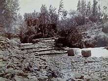
- Photo of fortifications, from 1862
