Ulpia Traiana Sarmizegetusa
| Colonia Dacica Sarmizegetusa | |
|---|---|
 The frontispiece of Forum In honorem domus divinae L(ucius) Ophonius Pap(iria) Domitius Priscus IIvir col(oniae) Dacic(ae) pecunia sua fecit l(ocus) d(atus) d(ecreto) d(ecurionum) | |
 Location within Romania | |
| Alternative name(s) | Colonia Dacica Sarmizegetusa, Zarmizegethusa,[1] Sarmategte,[1] Sarmazege[1] |
| Founded during the reign of | Trajan |
| Founded | 2nd century AD |
| Attested by | Tabula Peutingeriana |
| Place in the Roman world | |
| Province | Dacia |
| Administrative unit | Decimus Terentius Scaurianus |
| Structure | |
| — Stone structure — | |
| Size and area | 600 m × 540 m (32.4 ha) |
| Shape | Round rectangle |
| — Wood and earth[2] structure — | |
| Stationed military units | |
| — Legions — | |
| Location | |
| Coordinates | 45°30′47″N 22°47′14″E / 45.5130°N 22.7873°E |
| Altitude | c. 500 m |
| Town | Sarmizegetusa |
| County | Hunedoara |
| Country |
|
| Reference | |
| RO-LMI | HD-I-s-A-03205[3] |
| RO-RAN | 91063.01[3] |
| Site notes | |
| Recognition |
|
| Condition | Ruined |
Colonia Ulpia Traiana Augusta Dacica Sarmizegetusa was the capital and the largest city of Roman Dacia, later named Ulpia Traiana Sarmizegetusa after the former Dacian capital, located some 40 km away. Built on the ground of a camp of the Fifth Macedonian Legion, the city was settled by veterans of the Dacian wars. From the very beginning it received the title of colonia and the status of ius Italicum. With an area of 30 hectares (74 acres; 0.12 sq mi), a population between 20,000 and 25,000, and strong fortifications, Ulpia Traiana was the political, administrative and religious centre of Roman Dacia in the 2nd and 3rd centuries.
The city was destroyed by the Goths. Today Ulpia Traiana remains in ruins, with a partly preserved forum, an amphitheatre, and remnants of several temples.
History
.JPG)
The exact period when the city was built is not known. Some say the first settlement was erected between 106-107, others say it was between 108-110. However, due to an inscription discovered at the beginning of the 14th century in the village of Grădişte, it is known that the new town was settled in the first years after the conquest of Dacia. The inscription reads: "On the command of the emperor Caesar Nerva Traianus Augustus, son of the divine Nerva, was settled the Dacian Colony by Decimus Terentius Scaurianus, its governor."
In Rome, the settlement of the colony was marked by the minting of a coin, by order of the Senate, dedicated to emperor Trajan.
During the reign of Hadrian the city was renamed Colonia Ulpia Traiana Augusta Dacica Sarmizegetusa. Between 222 and 235 the colony was called a metropolis. The name was found on a stone inscription that reads "To Caius Arrius Quadratus, son of Gaius Arrius Antoninus, acting praetor of the emperor in Colonia Ulpia Traiana Augusta Dacica Sarmizegetusa." Gaius Arrius Antoninus bore the title legatus pro praetore, which was the official title of the governor of some imperial provinces of the Roman Empire.
Location
The settlement was built at a distance of 8 km from Tapae, a pass between Banat and Transylvania (today known as the Iron Gates of Transylvania). The choice was based on the military and economic advantages given by the natural barrier represented by the Retezat Mountains in the south and Poiana Ruscă Mountains in the north. The territory of the metropolis extended from Tibiscum to Micia and to the Jiu canyon, the city being protected by several castra: Tibiscum, Pons Augusti, Micia and castra of Bumbești.
The city was crossed by the imperial road from the Danube that linked the north of the province with Porolissum (Moigrad).
Archeological site
Today, the archeological site contains the following remains:
- Amphitheatre
- Gladiator school
- Goddess Nemesis Temple
- Liber Pater Temple
- Gods Aesculapius and Hygieia Temple
- Temple Basilica
- Temple of god Mithra
- Temple of palmyrans
- Great Temple
- God Silvanus Temple
- Glass blowers' workshops
- Horreum
- Financial procurator's office
- Thermae
- Forum
Virtual Reconstructions
These are the reconstructions published by Reconstituiri.ro:
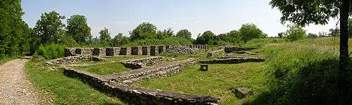
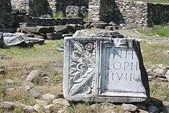
Image gallery
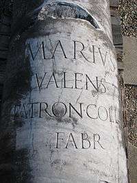 Inscription on the Forum Column
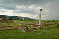 The Great Temple
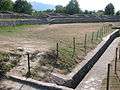 The Amphitheatre
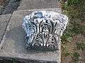 Column ornament
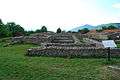 Temple of Nemesis
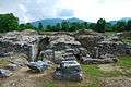 Curia
Curia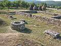 Glass workshop
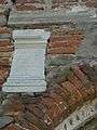 Roman tablet built into the medieval Orthodox church in Sânpetru.
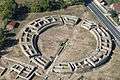 Aerial view
See also
Notes
- 1 2 3 Schütte, Gudmund (1917). "Ptolemy's maps of northern Europe, a reconstruction of the prototypes". The Royal Danish Geographical Society. Retrieved 2013-05-04.
- 1 2 Dumitru Protase: Castrul legiunii IIII Flavia de la Berzovia. Săpăturile arheologice din anii 1965–1968, p.41 Archived 2012-03-10 at the Wayback Machine.
- 1 2 "Colonia Ulpia Traiana Augusta Dacica Sarmizegetusa". National Archaeological Record of Romania (RAN). ran.cimec.ro. 2012-08-08. Retrieved 2014-03-20.
External links
| Wikimedia Commons has media related to Ulpia Traiana Sarmizegetusa. |
- (in English) ULPIA TRAIANA SARMIZEGETUSA
- (in Romanian) ULPIA TRAIANA SARMIZEGETUSA