Satara (city)
- For the moth genus, see Satara (moth).
| Satara सातारा Shahunagari | |
|---|---|
| City | |
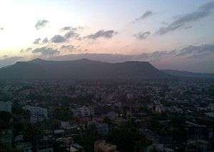
 Clockwise from top: Chaarbhinti, Natraj Mandir, The name of the city 'Satara' in three different scripts: Modi, Devnagri and Latin; Kshetra Mahuli, Ajinkyatara Fort, and the panorama of Satara city. | |
 Satara Location of Satara in Maharashtra | |
| Coordinates: 17°41′17″N 74°00′22″E / 17.688°N 74.006°ECoordinates: 17°41′17″N 74°00′22″E / 17.688°N 74.006°E | |
| Country |
|
| State | Maharashtra |
| District | Satara |
| Established | 16th century |
| Founded by | Chhatrapati Shahu |
| Area | |
| • Total | 22.42 km2 (8.66 sq mi) |
| Elevation | 742 m (2,434 ft) |
| Population (2011) | |
| • Total | 326,765 |
| Demonym(s) | Satarkar |
| Language | |
| • Official | Marathi |
| Time zone | UTC+5:30 (IST) |
| PIN |
415001,415002,415003, 415004,415005,415006, 415513 |
| Telephone code | 02162 |
| Vehicle registration | MH-11 |
| Website |
www |
Satara (Marathi: सातारा) (![]()
- Satara City has a unique statue of Shivaji maharaj standing near a canon, at Powai Naka.
- Kas plateau / Flower plateau is now a World Natural Heritage site.[2]
- Satara hosts 'Satara Half Hill Marathon' each year.[3] In 2015, they entered the Guinness World Records book for Most People in a Mountain Run (Single Mountain) with 2,618 runners.[4][5]
Satara city is known as a soldier's city. Satara is well connected by road and rail. The nearest bus station is MSRTC Satara. Mumbai airport is 260km away from Satara. Thoseghar falls is popular waterfall located at Thoseghar village in Satara district of Maharashtra. Thoseghar falls is among the most popular Satara attractions and one of the best monsoon tourist places near Mumbai. People come from all over the Maharashtra to visit the falls, especially during the monsoon season between July and October.
History
Medieval
The first Maratha invasion of the Deccan took place in 1296. In 1636 the Nizam Shahi dynasty came to an end. In 1663 Shivaji conquered Parali and Satara fort. After the death of Shivaji, Shahu Shivaji, heir apparent to the Maratha Kingdom, captured by Mughals when he was only seven years old, remained their prisoner till the death of his father in 1700. The Dowager Maharani Tarabai proclaimed his younger half-brother, and her son, Shahu Sambhaji as Chhatrapati Maharaj under her regency. Mughals released Shahu under certain preconditions in 1707, so that Marathas would face an internal war for the throne. Shahu returned to the Maratha Empire and claimed his inheritance. Aurangzeb's son Muhammad Azam Shah conquered Satara fort (Ajinkyatara) after a 6-month siege, later won by Parshuram Pratinidhi in 1706. In 1708 Chattrapati Shahu, the son of Chhatrapati Sambhaji, was crowned at the Satara fort. The direct descendents of Raja Shivaji continue to live in Satara. Udayanraje Bhonsle is the 13th descendent of Shivaji Maharaj. Dundle is the Sardar Of Chhatrpati Shivaji Maharaj. [6]
Features
- Satara is well known for its sweet: kandi pedhe.
- Satara is located at foot of the famous Ajinkyatara fort.
- Satara has a unique statue of Shivaji standing near a canon, at Powai Naka. Generally statue of Shivaji maharaj is seen him riding the horse.
- Kas plateau / Flower plateau, now a World Natural Heritage site.[2]
- Satara has two palaces in the heart the of city, the Old Palace (Juna Rajwada) and the New Palace (Nava Rajwada) adjoining each other. The Old Palace was built around 300 years ago, and the New Palace was built about 200 years ago.
- Thoseghar Waterfalls around 20 km west of Satara.
- Vajrai Waterfall, India's highest waterfall, around 22 km from Satara.
- Sajjangad, around 15 km from Satara.
How to visit
You can visit Satara by road, train or by air. It is about 250 km from capital city of Mumbai on national highway no. 48 (via Mumbai Pune Expressway and PB road). Train services from Chhatrapati Shivaji Maharaj Terminus railway station, Mumbai to Kolhapur via Satara. Private travels and government state transport buses are available from Borivali, Dadar, Mumbai Central and Thane to Satara. Satara is around 110 km from Pune (Pune International Airport is the nearest airport) by road.
Geography
Satara is located at 17°41′N 73°59′E / 17.68°N 73.98°E.[7] Satara city is surrounded by seven mountains.
It is located on National Highway 48 (formerly National Highway 4), between Karad and Khandala.[8]
Climate
Satara city has a pleasant climate all year round due to mountains surrounding the city. Summers are not too hot and winters are not too cold. Satara city receives moderate rainfall around 1,200 to 1,500 mm all year round.
| Climate data for Satara | |||||||||||||
|---|---|---|---|---|---|---|---|---|---|---|---|---|---|
| Month | Jan | Feb | Mar | Apr | May | Jun | Jul | Aug | Sep | Oct | Nov | Dec | Year |
| Average high °C (°F) | 29.0 (84.2) |
30.8 (87.4) |
34.6 (94.3) |
36.3 (97.3) |
34.8 (94.6) |
29.4 (84.9) |
25.4 (77.7) |
25.7 (78.3) |
27.2 (81) |
30.2 (86.4) |
28.6 (83.5) |
28.4 (83.1) |
30 (86.1) |
| Average low °C (°F) | 11.0 (51.8) |
12.6 (54.7) |
17.3 (63.1) |
20.1 (68.2) |
22.4 (72.3) |
21.6 (70.9) |
21.0 (69.8) |
20.4 (68.7) |
20.1 (68.2) |
18.6 (65.5) |
14.7 (58.5) |
11.2 (52.2) |
17.6 (63.7) |
| Average precipitation mm (inches) | 3.1 (0.122) |
1.3 (0.051) |
3.3 (0.13) |
18.3 (0.72) |
34.8 (1.37) |
134.4 (5.291) |
370.3 (14.579) |
296.9 (11.689) |
125.0 (4.921) |
81.5 (3.209) |
49.3 (1.941) |
6.9 (0.272) |
1,125.1 (44.295) |
| Source: Government of Maharashtra | |||||||||||||
Tourism

The famous tourist points near Satara city are:
- Ajinkyatara Fort (अजिंक्यतारा किल्ला)
- Raje Baksavar Peer Saaheb Dargha(khatgun)
- Sajjangad Fort (सज्जनगड किल्ला)
- Kaas Plateau – Called "Valley of flowers of Maharashtra" which is also a World Heritage Site
- Baramotichi Vihir Step well, near Limb village which is about 16 km from Satara

- Chaphal [Shree Ram Mandir, Near Patan][9]
Demographics
As of 2011 India census,[10] Satara had a population of 120,079; males constituted 52% of the population and females 48%. Satara has an average literacy rate of 80%, higher than the national average of 74%: male literacy is 84%, and female literacy is 76%. In Satara, 10% of the population is under 6 years of age. Marathi is the native and most widely spoken language.
Maharashtra state's sex ratio is 883 girls per 1000 boys, and Satara fares worse still at 881, in spite of the high level of literacy.[11] The population of Satara has crossed the municipal limits and actual urban agglomerate population 326,765.
Notable people
Transport
Satara city is well connected with the rest of Maharashtra by road and rail. National Highway 4 running between Mumbai and Chennai passes through Satara. A bypass was constructed in the 1990s to avoid traffic congestion in the city. NH4, a part of the Golden Quadrilateral, has been fully converted to a 4-lane divided highway while the stretch between Pune and Satara has been upgraded to 6-lane. National Highway 548C starts from Satara, Satara-Akluj-Latur Highway connects Satara city to Latur, it passes through Koregaon, Pusegaon, Mhaswad, Akluj, Tembhurni and Murud. It will also be a 4 lane highway, work is going to start soon. State Highway 58 connects Satara with Mahabaleshwar and Solapur.
Satara railway station lies on the Pune-Miraj line of the Central Railways and is administered by the Pune Railway Division. The railway station is located a small distance east of the city and is served by several express trains. Sahyadri Express, Koyna Express, Mahalaxmi Express, Maharashtra Express, Goa Express are daily trains that have stops at Satara. Satara Mahad Bankot is a newly declared national highway connecting Satara to the Konkan region.
See also
References
- ↑

- 1 2 3 Mulla, Mohsin (4 July 2012). "Kaas to bloom for only 2,000 tourists daily". Dnaindia.com.
- ↑ "Satara Hill Half Marathon on September 6 - Times of India". The Times of India. Retrieved 2017-10-25.
- ↑ Avlani, Shrenik (2016-01-04). "Runs you cannot miss in 2016". livemint.com/. Retrieved 2017-10-25.
- ↑ "Most people in a mountain run - single mountain". Guinness World Records. Retrieved 2017-10-25.
- ↑ "Satara". Royalark.net. Retrieved 18 August 2017.
- ↑ "Maps, Weather, and Airports for Satara, India". Fallingrain.com. Retrieved 18 August 2017.
- ↑ "Satara District Map". Mapsofindia.com. Retrieved 31 March 2015.
- ↑ "VirajTravels – Perfect place to find all holiday packages". virajtravels.in. Retrieved 18 August 2017.
- ↑ Cities having population 1 lakh and above. Censusindia.gov.in
- ↑ Babu, Chaya. 285 Indian girls no longer called "unwanted". Associated Press via MSNBC. 22 October 2011
Further reading
- Paul H. von Tucher: Nationalism: Case and crisis in Mission – German Missions in British India 1939 – 1946 Diss. Erlangen 1980. Author's edition Erlangen/Germany 1980. Read SATARA.
- Wilhelm Filchner: Life of a Researcher (chapter XXIII). Wilhelm Filchner was interned from September 1941 until November 1946 in the Parole Camp in Satara.
- Selections from the Historical Records of the Hereditary Minister of Baroda. Consisting of letters from Bombay, Baroda, Poona and Satara Governments. Collected by B. A. Gupte. Calcutta 1922.
- Malik, S. C. Stone Age Industries of the Bombay & Satara Districts, M. Sayajirao University Baroda 1959.
- Irawati Karve, Jayant Sadashiv Randadive, The Social Dynamics of a Growing Town and Its Surrounding Area. Deccan College, 1965, Poona. ISBN B0000CQW3J
- Valunjkar, T. N. Social Organization, Migration & Change in a Village Community, Deccan College Poona 1966.
- Dr. B.R.Ambedkar writes about his experience while living as a child in Satara in his autobiographical book, Waiting for a Visa
External links
| Wikimedia Commons has media related to Satara. |
Satara district topics | ||
|---|---|---|
| History |
|  |
| Battles | ||
| Rivers | ||
| Dams | ||
| Lakes |
| |
| Ghats | ||
| Caves | ||
| Cities and towns | ||
| Villages | ||
| Places to see |
| |
| Monuments | ||
| Transport | ||
| Education | ||
| Lok Sabha constituencies | ||
| Vidhan Sabha constituencies | ||
| Stadiums and Sports venues |
| |
| Culture | ||
| Topics | |||||||||||||
|---|---|---|---|---|---|---|---|---|---|---|---|---|---|
| Regions | |||||||||||||
| Divisions and Districts |
| ||||||||||||
| Million-plus cities in Maharashtra | |||||||||||||
| Other cities with municipal corporations | |||||||||||||
Portal: Maharashtra | |||||||||||||