Sakon Nakhon Province
| Sakon Nakhon สกลนคร | |||
|---|---|---|---|
| Province | |||
| |||
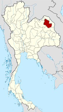 Map of Thailand highlighting Sakon Nakhon Province | |||
| Country | Thailand | ||
| Capital | Sakon Nakhon | ||
| Government | |||
| • Governor | Witthaya Chanchalong (since October 2016) | ||
| Area | |||
| • Total | 9,605.8 km2 (3,708.8 sq mi) | ||
| Area rank | Ranked 19th | ||
| Population (2014) | |||
| • Total | 1,138,609[1] | ||
| • Rank | Ranked 17th | ||
| • Density rank | Ranked 43rd | ||
| HDI | |||
| • HDI (2009) | 0.705 (medium) (62nd) | ||
| Time zone | UTC+7 (ICT) | ||
| Area code(s) | 042 | ||
| ISO 3166 code | TH-47 | ||
| Vehicle registration | สกลนคร | ||


Sakon Nakhon (Thai: สกลนคร, pronounced [sā.kōn ná(ʔ).kʰɔ̄ːn]) is one of the northeastern provinces (changwat) of Thailand. Neighboring provinces are (from north clockwise) Nong Khai, Bueng Kan, Nakhon Phanom, Mukdahan, Kalasin, and Udon Thani. The capital is Sakon Nakhon.
Etymology
The word sakon originates from the Sanskrit word sakala (Devanagari: सकल) meaning "entire", "whole", or "total", and the word nakhon from Sanskrit nagara (Devanagari: नगर) meaning "town" or "city". Hence the name of the province literally means "city of cities". In the Khmer language the province would be Sakor Nokor.
Geography
The province is on the Khorat Plateau, not far from the River Mekong. The Nong Han lake, the biggest natural lake of northeast Thailand, near the city of Sakon Nakhon, is a popular resort of the local people. The Phu Phan Mountains delimit the province to the south.
Symbols
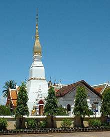
The provincial seal shows the Phrathat Choeng Chum, a Lao-style chedi built during the Ayutthaya period over a Khmer-style prang.
The provincial tree is the banaba or Queen's Crape Myrtle (Lagerstroemia speciosa).
Administrative divisions
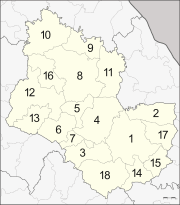
The province is divided into 18 districts (amphoe). The districts are further subdivided into 125 communes (tambon) and 1,323 villages (muban).
Economy
Fish and rice are two of the major products of the region.
Transportation
Roads
Route 22 leads north to Udon Thani, 160 km distant, and east to Nakhon Phanom (91 km) and the border with Laos. Route 223 leads south to That Phanom (76 km). Route 213 leads west to Kalasin (131 km).
Air
There is a regional airport, Sakon Nakhon Airport, on the north side of the city.[2]
See also
References
- ↑ "Population of the Kingdom" (PDF). Department of Provincial Affairs (DOPA) Thailand (in Thai). 2014-12-31. Retrieved 19 Mar 2015.
- ↑ "Sakon Nakhon Airport". OurAirports. Retrieved 3 February 2013.
External links

- Provincial page from the Tourist Authority of Thailand
- Website of province (Thai only)
Places adjacent to Sakon Nakhon Province | |
|---|---|
Coordinates: 17°9′15″N 104°8′10″E / 17.15417°N 104.13611°E