That Phanom District
| That Phanom ธาตุพนม | |
|---|---|
| District | |
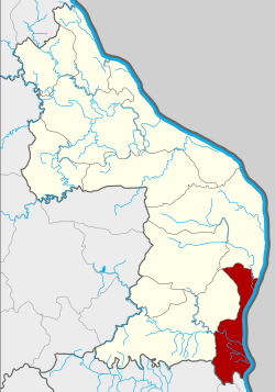 District location in Nakhon Phanom Province | |
| Coordinates: 16°56′11″N 104°42′34″E / 16.93639°N 104.70944°ECoordinates: 16°56′11″N 104°42′34″E / 16.93639°N 104.70944°E | |
| Country | Thailand |
| Province | Nakhon Phanom |
| Seat | That Phanom |
| Area | |
| • Total | 367.9 km2 (142.0 sq mi) |
| Population (2008) | |
| • Total | 83,478 |
| • Density | 228.3/km2 (591/sq mi) |
| Time zone | UTC+7 (ICT) |
| Postal code | 48110 |
| Geocode | 4805 |
That Phanom (Thai: ธาตุพนม, pronounced [tʰâːt pʰā.nōm]) is a district (amphoe) in the southern part of Nakhon Phanom Province, northeastern Thailand.
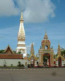
The district is named after Wat Phra That Phanom, the most important Buddhist temple in the region.
Geography
Neighboring districts are (from the south clockwise) Wan Yai, Mueang Mukdahan, Dong Luang of Mukdahan Province, Na Kae, Renu Nakhon, and Mueang Nakhon Phanom of Nakhon Phanom Province. To the east across the Mekong River is the Laotian province Khammouan.
History
In 1917, the district name was changed from Renu Nakhon (เรณูนคร) to That Phanom.[1]
Administration
The district is divided into 12 sub-districts (tambons), which are further subdivided into 142 villages (mubans). The sub-district municipality (thesaban tambon) That Phanom covers parts of tambon That Phanom and That Phanom Nuea. There are a further 11 tambon administrative organizations (TAO).
| No. | Name | Thai | Villages | Pop.[2] |
|---|---|---|---|---|
| 1. | That Phanom | ธาตุพนม | 19 | 11,238 |
| 2. | Fang Daeng | ฝั่งแดง | 11 | 6,963 |
| 3. | Phon Phaeng | โพนแพง | 8 | 4,862 |
| 4. | Phra Klang Thung | พระกลางทุ่ง | 16 | 7,598 |
| 5. | Na Thon | นาถ่อน | 15 | 8,729 |
| 6. | Saen Phan | แสนพัน | 8 | 4,002 |
| 7. | Don Nang Hong | ดอนนางหงส์ | 11 | 6,837 |
| 8. | Nam Kam | น้ำก่ำ | 20 | 12,160 |
| 9. | Um Mao | อุ่มเหม้า | 9 | 5,463 |
| 10. | Na Nat | นาหนาด | 10 | 5,515 |
| 11. | Kut Chim | กุดฉิม | 7 | 4,448 |
| 12. | That Phanom Nuea | ธาตุพนมเหนือ | 8 | 5,663 |
Economy
The district's location on a bank of the Mekong has made it a prime agricultural area. Tomatoes, in particular, are one of the more profitable crops.[3]
References
- ↑ ประกาศกระทรวงมหาดไทย เรื่อง เปลี่ยนชื่ออำเภอ (PDF). Royal Gazette (in Thai). 34 (0 ก): 40–68. 1917-04-29.
- ↑ "Population statistics 2008". Department of Provincial Administration. Archived from the original on 2009-09-16.
- ↑ Rujivanarom, Pratch (4 October 2018). "Upstream dams a threat to tomatoes, farmers". The Nation. Retrieved 5 October 2018.
External links
- amphoe.com (Thai)