Saint-Sornin-Leulac
| Saint-Sornin-Leulac | ||
|---|---|---|
| Commune | ||
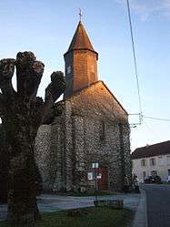 The church in Saint-Sornin-Leulac | ||
| ||
 Saint-Sornin-Leulac Location within Nouvelle-Aquitaine region  Saint-Sornin-Leulac | ||
| Coordinates: 46°12′00″N 1°17′54″E / 46.20000°N 1.2983°ECoordinates: 46°12′00″N 1°17′54″E / 46.20000°N 1.2983°E | ||
| Country | France | |
| Region | Nouvelle-Aquitaine | |
| Department | Haute-Vienne | |
| Arrondissement | Bellac | |
| Canton | Châteauponsac | |
| Intercommunality | Gartempe – Saint Pardoux | |
| Government | ||
| • Mayor (2008–2014) | Marcel Leterre | |
| Area1 | 32.28 km2 (12.46 sq mi) | |
| Population (2006)2 | 669 | |
| • Density | 21/km2 (54/sq mi) | |
| Time zone | UTC+1 (CET) | |
| • Summer (DST) | UTC+2 (CEST) | |
| INSEE/Postal code | 87180 /87290 | |
| Elevation | 246–365 m (807–1,198 ft) | |
|
1 French Land Register data, which excludes lakes, ponds, glaciers > 1 km2 (0.386 sq mi or 247 acres) and river estuaries. 2 Population without double counting: residents of multiple communes (e.g., students and military personnel) only counted once. | ||
.svg.png)
Saint-Sornin-Leulac (Occitan: Sent Sòrnin) is a commune in the Haute-Vienne department in the Nouvelle-Aquitaine region in west-central France.
Geography
The river Brame flows westward through the northern part of the commune.
See also
References
| Wikimedia Commons has media related to Saint-Sornin-Leulac. |
This article is issued from
Wikipedia.
The text is licensed under Creative Commons - Attribution - Sharealike.
Additional terms may apply for the media files.