Saint-Méard
| Saint-Méard | |
|---|---|
| Commune | |
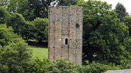 The Échizadour Tower, in Saint-Méard | |
 Saint-Méard Location within Nouvelle-Aquitaine region  Saint-Méard | |
| Coordinates: 45°39′57″N 1°32′57″E / 45.6658°N 1.5492°ECoordinates: 45°39′57″N 1°32′57″E / 45.6658°N 1.5492°E | |
| Country | France |
| Region | Nouvelle-Aquitaine |
| Department | Haute-Vienne |
| Arrondissement | Limoges |
| Canton | Eymoutiers |
| Intercommunality | Briance Combade |
| Government | |
| • Mayor (2008–2014) | Henri Lavaud |
| Area1 | 24.51 km2 (9.46 sq mi) |
| Population (2006)2 | 377 |
| • Density | 15/km2 (40/sq mi) |
| Time zone | UTC+1 (CET) |
| • Summer (DST) | UTC+2 (CEST) |
| INSEE/Postal code | 87170 /87130 |
| Elevation | 330–560 m (1,080–1,840 ft) |
|
1 French Land Register data, which excludes lakes, ponds, glaciers > 1 km2 (0.386 sq mi or 247 acres) and river estuaries. 2 Population without double counting: residents of multiple communes (e.g., students and military personnel) only counted once. | |
Saint-Méard (Occitan: Sent Mèrd) is a commune in the Haute-Vienne department in the Nouvelle-Aquitaine region in west-central France.
Geography
The river Briance flows northwestward through the western part of the commune.
See also
References
| Wikimedia Commons has media related to Saint-Méard. |
This article is issued from
Wikipedia.
The text is licensed under Creative Commons - Attribution - Sharealike.
Additional terms may apply for the media files.