Arnac-la-Poste
| Arnac-la-Poste | |
|---|---|
| Commune | |
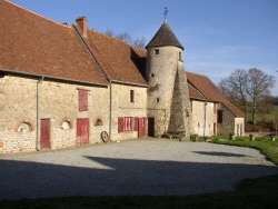 The Montmagner post house | |
 Arnac-la-Poste Location within Nouvelle-Aquitaine region  Arnac-la-Poste | |
| Coordinates: 46°16′39″N 1°22′29″E / 46.27750°N 1.3747°ECoordinates: 46°16′39″N 1°22′29″E / 46.27750°N 1.3747°E | |
| Country | France |
| Region | Nouvelle-Aquitaine |
| Department | Haute-Vienne |
| Arrondissement | Bellac |
| Canton | Châteauponsac |
| Intercommunality | CC Haut-Limousin Marche |
| Government | |
| • Mayor (2014-2020) | Mariane Deverines |
| Area1 | 46.62 km2 (18.00 sq mi) |
| Population (2015)2 | 983 |
| • Density | 21/km2 (55/sq mi) |
| Time zone | UTC+1 (CET) |
| • Summer (DST) | UTC+2 (CEST) |
| INSEE/Postal code | 87003 /87160 |
| Elevation | 249–384 m (817–1,260 ft) |
|
1 French Land Register data, which excludes lakes, ponds, glaciers > 1 km2 (0.386 sq mi or 247 acres) and river estuaries. 2 Population without double counting: residents of multiple communes (e.g., students and military personnel) only counted once. | |
Arnac-la-Poste (Occitan: Arnac) is a commune in the Haute-Vienne department in the Nouvelle-Aquitaine region in western France.
Geography
The river Benaize forms part of the commune's northern border.
The river Brame flows westward through the commune's southern part.
See also
References
| Wikimedia Commons has media related to Arnac-la-Poste. |
This article is issued from
Wikipedia.
The text is licensed under Creative Commons - Attribution - Sharealike.
Additional terms may apply for the media files.