Les Billanges
| Les Billanges | ||
|---|---|---|
| Commune | ||
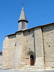 The church of the Nativity of Saint-Jean-Baptiste, in Les Billanges | ||
| ||
 Les Billanges Location within Nouvelle-Aquitaine region  Les Billanges | ||
| Coordinates: 45°57′53″N 1°32′03″E / 45.9647°N 1.5342°ECoordinates: 45°57′53″N 1°32′03″E / 45.9647°N 1.5342°E | ||
| Country | France | |
| Region | Nouvelle-Aquitaine | |
| Department | Haute-Vienne | |
| Arrondissement | Limoges | |
| Canton | Ambazac | |
| Intercommunality | Monts d'Ambazac et du Val du Taurion | |
| Government | ||
| • Mayor (2008–2014) | Manuel Perthuisot | |
| Area1 | 22.61 km2 (8.73 sq mi) | |
| Population (2006)2 | 306 | |
| • Density | 14/km2 (35/sq mi) | |
| Time zone | UTC+1 (CET) | |
| • Summer (DST) | UTC+2 (CEST) | |
| INSEE/Postal code | 87016 /87340 | |
| Elevation | 280–451 m (919–1,480 ft) | |
|
1 French Land Register data, which excludes lakes, ponds, glaciers > 1 km2 (0.386 sq mi or 247 acres) and river estuaries. 2 Population without double counting: residents of multiple communes (e.g., students and military personnel) only counted once. | ||
.svg.png)
Les Billanges (Occitan: Los Bilanges) is a commune in the Haute-Vienne department in the Nouvelle-Aquitaine region in western France.
Inhabitants are known as Billangeots.
See also
References
| Wikimedia Commons has media related to Les Billanges. |
This article is issued from
Wikipedia.
The text is licensed under Creative Commons - Attribution - Sharealike.
Additional terms may apply for the media files.