Azat-le-Ris
| Azat-le-Ris | ||
|---|---|---|
| Commune | ||
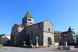 Saint-Genest church | ||
| ||
 Azat-le-Ris Location within Nouvelle-Aquitaine region  Azat-le-Ris | ||
| Coordinates: 46°19′14″N 1°03′36″E / 46.3206°N 1.06000°ECoordinates: 46°19′14″N 1°03′36″E / 46.3206°N 1.06000°E | ||
| Country | France | |
| Region | Nouvelle-Aquitaine | |
| Department | Haute-Vienne | |
| Arrondissement | Bellac | |
| Canton | Châteauponsac | |
| Intercommunality | CC Haut-Limousin Marche | |
| Government | ||
| • Mayor (2014-2020) | Jacques Benot | |
| Area1 | 56.22 km2 (21.71 sq mi) | |
| Population (2015)2 | 261 | |
| • Density | 4.6/km2 (12/sq mi) | |
| Time zone | UTC+1 (CET) | |
| • Summer (DST) | UTC+2 (CEST) | |
| INSEE/Postal code | 87006 /87360 | |
| Elevation | 1,790–282 m (5,873–925 ft) | |
|
1 French Land Register data, which excludes lakes, ponds, glaciers > 1 km2 (0.386 sq mi or 247 acres) and river estuaries. 2 Population without double counting: residents of multiple communes (e.g., students and military personnel) only counted once. | ||
.svg.png)
Azat-le-Ris (Occitan: Asac lo Riu) is a commune in the Haute-Vienne department in the Nouvelle-Aquitaine region in western France.
Geography
The Salleron has its source in the commune.
See also
References
| Wikimedia Commons has media related to Azat-le-Ris. |
This article is issued from
Wikipedia.
The text is licensed under Creative Commons - Attribution - Sharealike.
Additional terms may apply for the media files.