Eybouleuf
| Eybouleuf | |
|---|---|
| Commune | |
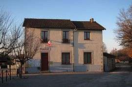 The town hall in Eybouleuf | |
 Eybouleuf Location within Nouvelle-Aquitaine region  Eybouleuf | |
| Coordinates: 45°47′46″N 1°28′59″E / 45.7961°N 1.4831°ECoordinates: 45°47′46″N 1°28′59″E / 45.7961°N 1.4831°E | |
| Country | France |
| Region | Nouvelle-Aquitaine |
| Department | Haute-Vienne |
| Arrondissement | Limoges |
| Canton | Saint-Léonard-de-Noblat |
| Intercommunality | Noblat |
| Government | |
| • Mayor (2008–2014) | Le Don |
| Area1 | 10.83 km2 (4.18 sq mi) |
| Population (2006)2 | 350 |
| • Density | 32/km2 (84/sq mi) |
| Time zone | UTC+1 (CET) |
| • Summer (DST) | UTC+2 (CEST) |
| INSEE/Postal code | 87062 /87400 |
| Elevation | 270–433 m (886–1,421 ft) |
|
1 French Land Register data, which excludes lakes, ponds, glaciers > 1 km2 (0.386 sq mi or 247 acres) and river estuaries. 2 Population without double counting: residents of multiple communes (e.g., students and military personnel) only counted once. | |
Eybouleuf (Occitan: Esboleu) is a commune in the Haute-Vienne department in the Nouvelle-Aquitaine region in western France.
Inhabitants are known as Saccas.
See also
References
| Wikimedia Commons has media related to Eybouleuf. |
This article is issued from
Wikipedia.
The text is licensed under Creative Commons - Attribution - Sharealike.
Additional terms may apply for the media files.