Oradour-Saint-Genest
| Oradour-Saint-Genest | |
|---|---|
| Commune | |
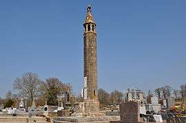 The lantern of the dead, in Oradour-Saint-Genest | |
 Oradour-Saint-Genest Location within Nouvelle-Aquitaine region  Oradour-Saint-Genest | |
| Coordinates: 46°14′21″N 1°02′09″E / 46.2392°N 1.0358°ECoordinates: 46°14′21″N 1°02′09″E / 46.2392°N 1.0358°E | |
| Country | France |
| Region | Nouvelle-Aquitaine |
| Department | Haute-Vienne |
| Arrondissement | Bellac |
| Canton | Châteauponsac |
| Intercommunality | Basse Marche |
| Government | |
| • Mayor (2008–2014) | Gilles Reynaud |
| Area1 | 37.90 km2 (14.63 sq mi) |
| Population (2006)2 | 467 |
| • Density | 12/km2 (32/sq mi) |
| Time zone | UTC+1 (CET) |
| • Summer (DST) | UTC+2 (CEST) |
| INSEE/Postal code | 87109 /87210 |
| Elevation | 160–249 m (525–817 ft) |
|
1 French Land Register data, which excludes lakes, ponds, glaciers > 1 km2 (0.386 sq mi or 247 acres) and river estuaries. 2 Population without double counting: residents of multiple communes (e.g., students and military personnel) only counted once. | |
Oradour-Saint-Genest (Occitan: Orador Sent Genès) is a commune in the Haute-Vienne department in the Nouvelle-Aquitaine region in west-central France.
Geography
The river Brame flows northwestward through the commune.
See also
References
| Wikimedia Commons has media related to Oradour-Saint-Genest. |
This article is issued from
Wikipedia.
The text is licensed under Creative Commons - Attribution - Sharealike.
Additional terms may apply for the media files.