Javerdat
| Javerdat | ||
|---|---|---|
| Commune | ||
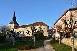 The church and town hall in Javerdat | ||
| ||
 Javerdat Location within Nouvelle-Aquitaine region  Javerdat | ||
| Coordinates: 45°57′18″N 0°59′09″E / 45.95500°N 0.9858°ECoordinates: 45°57′18″N 0°59′09″E / 45.95500°N 0.9858°E | ||
| Country | France | |
| Region | Nouvelle-Aquitaine | |
| Department | Haute-Vienne | |
| Arrondissement | Rochechouart | |
| Canton | Saint-Junien | |
| Intercommunality | Vienne Glane | |
| Government | ||
| • Mayor (2008–2014) | Annie Dardilhac | |
| Area1 | 25.52 km2 (9.85 sq mi) | |
| Population (2006)2 | 606 | |
| • Density | 24/km2 (62/sq mi) | |
| Time zone | UTC+1 (CET) | |
| • Summer (DST) | UTC+2 (CEST) | |
| INSEE/Postal code | 87078 /87520 | |
| Elevation | 228–336 m (748–1,102 ft) | |
|
1 French Land Register data, which excludes lakes, ponds, glaciers > 1 km2 (0.386 sq mi or 247 acres) and river estuaries. 2 Population without double counting: residents of multiple communes (e.g., students and military personnel) only counted once. | ||
.svg.png)
Javerdat (Occitan: Javerdac) is a commune in the Haute-Vienne department in the Nouvelle-Aquitaine region in west-central France.
See also
References
External links
| Wikimedia Commons has media related to Javerdat. |
This article is issued from
Wikipedia.
The text is licensed under Creative Commons - Attribution - Sharealike.
Additional terms may apply for the media files.