Saint-Barbant
| Saint-Barbant | |
|---|---|
| Commune | |
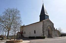 The church in Saint-Barbant | |
 Saint-Barbant Location within Nouvelle-Aquitaine region  Saint-Barbant | |
| Coordinates: 46°10′22″N 0°51′01″E / 46.1728°N 0.8503°ECoordinates: 46°10′22″N 0°51′01″E / 46.1728°N 0.8503°E | |
| Country | France |
| Region | Nouvelle-Aquitaine |
| Department | Haute-Vienne |
| Arrondissement | Bellac |
| Canton | Bellac |
| Intercommunality | Haut Limousin |
| Government | |
| • Mayor (2008–2014) | Jeanine Labrousse |
| Area1 | 42.47 km2 (16.40 sq mi) |
| Population (2006)2 | 366 |
| • Density | 8.6/km2 (22/sq mi) |
| Time zone | UTC+1 (CET) |
| • Summer (DST) | UTC+2 (CEST) |
| INSEE/Postal code | 87136 /87330 |
| Elevation | 144–247 m (472–810 ft) |
|
1 French Land Register data, which excludes lakes, ponds, glaciers > 1 km2 (0.386 sq mi or 247 acres) and river estuaries. 2 Population without double counting: residents of multiple communes (e.g., students and military personnel) only counted once. | |
Saint-Barbant (Occitan: Sent Barbant) is a commune in the Haute-Vienne department in the Nouvelle-Aquitaine region in west-central France.
Inhabitants are known as Saint-Barbanteaux.
See also
References
| Wikimedia Commons has media related to Saint-Barbant. |
This article is issued from
Wikipedia.
The text is licensed under Creative Commons - Attribution - Sharealike.
Additional terms may apply for the media files.