Arrondissement of Saint-Brieuc
| Saint-Brieuc | |
|---|---|
| Arrondissement | |
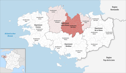 Arrondissement of Saint-Brieuc in Côtes-d'Armor | |
| Country | France |
| Region | Brittany |
| Department | Côtes-d'Armor |
| Communes | 116 |
| Prefecture | Saint-Brieuc |
| Area¹ | |
| • Total | 2,697 km2 (1,041 sq mi) |
| Population (2013) | |
| • Total | 270,374 |
| • Density | 100/km2 (260/sq mi) |
| ¹ French Land Register data, which exclude lakes, ponds, and glaciers larger than 1 km² as well as the estuaries of rivers. | |
The arrondissement of Saint-Brieuc is an arrondissement of France in the Côtes-d'Armor department in the Brittany region. Since the January 2017 reorganization of the arrondissements of Côtes-d'Armor, it has 116 communes.[1]
Composition
Cantons
The cantons of the arrondissement of Saint-Brieuc are:
- Broons (partly)
- Lamballe
- Loudéac
- Mûr-de-Bretagne
- Paimpol (partly)
- Plaintel
- Plélo (partly)
- Plénée-Jugon
- Pléneuf-Val-André (partly)
- Plérin
- Ploufragan
- Plouha (partly)
- Saint-Brieuc-1
- Saint-Brieuc-2
- Trégueux
Communes
The communes of the arrondissement of Saint-Brieuc, and their INSEE codes, are:
- Allineuc (22001)
- Andel (22002)
- Binic-Étables-sur-Mer (22055)
- Le Bodéo (22009)
- La Bouillie (22012)
- Bréhand (22015)
- Le Cambout (22027)
- Caurel (22033)
- La Chèze (22039)
- Coëtlogon (22043)
- Coëtmieux (22044)
- Corlay (22047)
- Éréac (22053)
- Erquy (22054)
- Le Fœil (22059)
- Gausson (22060)
- Gomené (22062)
- Grâce-Uzel (22068)
- Guerlédan (22158)
- La Harmoye (22073)
- Le Haut-Corlay (22074)
- Hémonstoir (22075)
- Hénanbihen (22076)
- Hénansal (22077)
- Hénon (22079)
- Hillion (22081)
- Île-de-Bréhat (22016)
- Illifaut (22083)
- Jugon-les-Lacs-Commune-Nouvelle (22084)
- Lamballe (22093)
- Landéhen (22098)
- Lanfains (22099)
- Langast (22100)
- Langueux (22106)
- Lanrelas (22114)
- Lantic (22117)
- Laurenan (22122)
- Le Leslay (22126)
- Loscouët-sur-Meu (22133)
- Loudéac (22136)
- La Malhoure (22140)
- La Méaugon (22144)
- Le Mené (22046)
- Merdrignac (22147)
- Mérillac (22148)
- Merléac (22149)
- Moncontour (22153)
- Morieux (22154)
- La Motte (22155)
- Les Moulins (22183)
- Noyal (22160)
- Penguily (22165)
- Plaine-Haute (22170)
- Plaintel (22171)
- Planguenoual (22173)
- Plédéliac (22175)
- Plédran (22176)
- Plémy (22184)
- Plénée-Jugon (22185)
- Pléneuf-Val-André (22186)
- Plérin (22187)
- Plestan (22193)
- Plœuc-l'Hermitage (22203)
- Ploufragan (22215)
- Plouguenast (22219)
- Plourhan (22232)
- Plumieux (22241)
- Plurien (22242)
- Plussulien (22244)
- Pommeret (22246)
- Pordic (22251)
- La Prénessaye (22255)
- Quessoy (22258)
- Le Quillio (22260)
- Quintenic (22261)
- Quintin (22262)
- Rouillac (22267)
- Saint-Alban (22273)
- Saint-Barnabé (22275)
- Saint-Bihy (22276)
- Saint-Brandan (22277)
- Saint-Brieuc (22278)
- Saint-Caradec (22279)
- Saint-Carreuc (22281)
- Saint-Connec (22285)
- Saint-Denoual (22286)
- Saint-Donan (22287)
- Saint-Étienne-du-Gué-de-l'Isle (22288)
- Saint-Gildas (22291)
- Saint-Gilles-Vieux-Marché (22295)
- Saint-Glen (22296)
- Saint-Hervé (22300)
- Saint-Julien (22307)
- Saint-Launeuc (22309)
- Saint-Martin-des-Prés (22313)
- Saint-Maudan (22314)
- Saint-Mayeux (22316)
- Saint-Quay-Portrieux (22325)
- Saint-Rieul (22326)
- Saint-Thélo (22330)
- Saint-Trimoël (22332)
- Saint-Vran (22333)
- Sévignac (22337)
- Tramain (22341)
- Trébry (22345)
- Trédaniel (22346)
- Trédias (22348)
- Trégueux (22360)
- Trémeur (22369)
- Trémorel (22371)
- Trémuson (22372)
- Trévé (22376)
- Tréveneuc (22377)
- Uzel (22384)
- Le Vieux-Bourg (22386)
- Yffiniac (22389)
References
- ↑ "Arrêté préfectoral, 8 December 2016, p 7" (PDF). Retrieved 2017-07-31.
External links
This article is issued from
Wikipedia.
The text is licensed under Creative Commons - Attribution - Sharealike.
Additional terms may apply for the media files.