Tanintharyi Region
| Tanintharyi Region တနင်္သာရီတိုင်းဒေသကြီး | ||
|---|---|---|
| Region | ||
| Myanma transcription(s) | ||
| • Burmese | ta.nangsari. tuing: desa. kri: | |
| ||
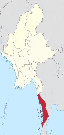 Location of Tanintharyi Region in Myanmar | ||
| Coordinates: 13°0′N 98°45′E / 13.000°N 98.750°ECoordinates: 13°0′N 98°45′E / 13.000°N 98.750°E | ||
| Country |
| |
| Region | South | |
| Capital | Dawei (Tavoy) | |
| Government | ||
| • Chief Minister | Le Le Maw (NLD) | |
| • Cabinet | Tanintharyi Region Government | |
| • Legislature | Taninthayi Region Hluttaw | |
| • High Court | Tanintharyi Region High Court | |
| Area | ||
| • Total | 43,344.9 km2 (16,735.6 sq mi) | |
| Area rank | 5th | |
| Population (2014)[1] | ||
| • Total | 1,408,401 | |
| • Rank | 12th | |
| • Density | 32/km2 (84/sq mi) | |
| Demographics | ||
| • Ethnicities | Bamar, Dawei, Rakhine, Mon, Shan, Burmese-Thai, Kayin, Salone, Malay | |
| • Religions | Buddhism 87.50%, Christianity 7.20% Islam 5.10%, Hinduism 0.10% | |
| Time zone | UTC+06:30 (MMT) | |
| ISO 3166 code | MM-05 | |
Tanintharyi Region (Burmese: တနင်္သာရီတိုင်းဒေသကြီး, pronounced [tənɪ́ɴθàjì táɪɴ dèθa̰ dʑí]; Mon: ဏၚ်ကသဳ or တနၚ်သြဳ; Malay: Tanah Sari; formerly Tenasserim Division and subsequently Tanintharyi Division) is an administrative region of Myanmar, covering the long narrow southern part of the country on the Kra Isthmus. It borders the Andaman Sea to the west and the Tenasserim Hills, beyond which lies Thailand, to the east. To the north is the Mon State. There are many islands off the coast, the large Mergui Archipelago in the southern and central coastal areas and the smaller Moscos Islands off the northern shores. The capital of the division is Dawei (Tavoy). Other important cities are Myeik (Mergui) and Kawthaung. The division covers an area of 43,344.9 km², and had a population of 1,406,434 at the 2014 Census.
Names
In Thai, the region is known as "Tanao Si" (ตะนาวศรี), pronounced [tənaːw sǐː]), while in Malay, it is known as Tanah Sari (تانه ساري). "Tanah Sari Region" was part of "Tanah Melayu" or " Malay Peninsular, part of the Kingdom of Kedah and later the Sultanate of Kedah. It was initially occupied by the Ayutthaya Kingdom and later occupied by Burma.
History
| Historical population | ||
|---|---|---|
| Year | Pop. | ±% |
| 1973 | 719,441 | — |
| 1983 | 917,247 | +27.5% |
| 2014 | 1,408,401 | +53.5% |
| Source: 2014 Myanmar Census[1] | ||
Tanintharyi Region historically included the entire Tanintharyi salient—today's Tanintharyi Region, Mon State and southern Kayin State. The northernmost region was part of the Thaton Kingdom before 1057, and the entire coastline became part of King Anawrahta's Pagan Empire after 1057. After the fall of Bagan in 1287, the area fell to the Siamese kingdom of Sukhothai, and later its successor Ayutthaya Kingdom. The region's northernmost border was around the Thanlwin (Salween) river near today's Mawlamyaing (Moulmein).
The region reverted to Burmese fold in 1564 when King Bayinnaung of Toungoo Dynasty conquered all of Siam. Ayutthaya had regained independence by 1587, and reclaimed the southern half of Tanintharyi in 1593 and the entire peninsula in 1599.[2] In 1614, King Anaukpetlun recovered the upper half of the coast to Dawei but failed to capture the rest.[3] Tenasserim south of Dawei (Tavoy) remained under Siamese control. Myeik (Mergui) port was a principal center of trade between the Siamese and Europeans.[4]
For nearly seven decades, from the middle of the 18th century to the early 19th century, Burma and Siam were involved in multiple wars for control of the coastline. Taking advantage of the Burmese civil war of 1740–1757, the Siamese cautiously moved up the coastline to the south of Mottama in 1751. The winner of the civil war, King Alaungpaya of Konbaung Dynasty recovered the coastline to Dawei from the Siamese in 1760. His son King Hsinbyushin conquered the entire coastline in 1765.[4] In the following decades, both sides tried to extend the line of control to their advantage but they both failed. The Burmese used Tanintharyi as a forward base to launch several unsuccessful invasions of Siam (1775–1776; 1785–1786; 1809–1812); the Siamese too were unsuccessful in their attempts to retake Tanintharyi (1787 and 1792).[5] (On the northern front, Burma and Siam were also locked in a struggle for the control of Kengtung and Lan Na.)
Burma ceded the region south of Salween river to the British after the First Anglo-Burmese War (1824–1826) per the Treaty of Yandabo. The British and the Siamese signed a boundary demarcation treaty on 20 June 1826, and another one in 1868.[2] Mawlamyaing (Moulmein) became the first capital of British Burma. The British seized all of Lower Burma after the Second Anglo-Burmese War of 1852, and moved the capital to Yangon (Rangoon). After 1852, Tanintharyi Region consisted the entire southeastern Myanmar, including today's Mon State, Kayin State, and Taungoo District, in Bago Region. Mawlamyaing was the capital of Tanintharyi.[6]
Upon independence from Britain in 1948, the northeastern districts of Tanintharyi were placed into the newly created Karen State. In 1974, the northern part of remaining Tanintharyi was carved out to create Mon State.[6] With Mawlamyaing now inside Mon State, the capital of Tanintharyi Region was moved to Dawei. In 1989 the division's English spelling was officially changed to Tanintharyi.
Administrative divisions
Tanintharyi Region comprises ten townships spread over three districts:
Government
Legislature
Transport
A rail service runs from Rangoon twice every week. A deepwater port is planned in Dawei, a project that includes a highway and a railway line between Bangkok and that harbor.[7]
The Maw Daung pass international cross-border checkpoint into Thailand has been developed since 2014.[8][9]
Demographics
Religion
Buddhism is practiced by the majority of the population.
Economy
Myanmar consists of fourteen provinces including seven states and seven divisions. Tanintharyi is one of the province of Myanmar, lies at the southern end of Myanmar. It is located close to the sea, a major part of its economy. The natural resources from this region, mostly the jewels are very popular not only in Myanmar but also in the globe. Since Tanintharyi is a region where agriculture can be achieved, agricultural products can also be found.
Natural resources are plentiful in this region. Famous mines in this region are Heinda, Hamyingyi, Kanbauk, Yawa, Kyaukmetaung, Nanthida and Yadanabon where a lot of metal can be found. Pearls cultured at the Pearl Island creates much budget obtained from foreign countries at the Myanmar Gems Emporia. Those jewels are distributed many parts of Myanmar and other countries either. Figuratively, Tanintharyi region can be called big oil pot of Myanmar. Because an edible vegetable oil derived from the fruit of the oil palms, grown mainly in this region.
Because of the suitable weather, rubber trees can be grown in Tanintharyi. It is also a source of many products. For the sea fishing industry, they are being arranged along Tanintharyi coast not only for consumers from Myanmar but also for export mostly to Thailand. Birds' nest is also being gathered from offshore islands. This part of the country is the main fishery product market of Myanmar. Food such as dried fish, dried prawn, dried shrimp and Ngapi (shrimp paste) are popularly derived from this region.
Education
Educational opportunities in Myanmar are extremely limited outside the main cities of Yangon and Mandalay. According to official statistics, less than 10% of primary school students in the division reach high school.[11]
| AY 2002-2003 | Primary | Middle | High |
|---|---|---|---|
| Schools | 1011 | 59 | 30 |
| Teachers | 3000 | 1300 | 400 |
| Students | 170,000 | 54,000 | 14,000 |
All Tanintharyi's 7 universities and colleges are located in Dawei and Myeik. Until recently, Dawei University was the only four-year university in the Region.
Health care
The general state of health care in Myanmar is poor. The government spends anywhere from 0.5% to 3% of the country's GDP on health care, consistently ranking among the lowest in the world.[12][13] Although health care is nominally free, in reality, patients have to pay for medicine and treatment, even in public clinics and hospitals. Public hospitals lack many of the basic facilities and equipment. Moreover, the health care infrastructure outside of Yangon and Mandalay is extremely poor. In 2003, the entire Tanintharyi Region had fewer hospital beds than the Yangon General Hospital. The following is a summary of the public health care system.[14]
| 2002–2003 | # Hospitals | # Beds |
|---|---|---|
| Specialist hospitals | 0 | 0 |
| General hospitals with specialist services | 2 | 400 |
| General hospitals | 10 | 346 |
| Health clinics | 14 | 224 |
| Total | 26 | 970 |
References
- 1 2 Census Report. The 2014 Myanmar Population and Housing Census. 2. Naypyitaw: Ministry of Immigration and Population. May 2015. p. 17.
- 1 2 "International Boundary Study: Burma-Thailand Boundary" (PDF). Bureau of Intelligence and Research, US Department of State. 1966-02-01.
- ↑ Helen James (2004). Keat Gin Ooi, ed. Southeast Asia: a historical encyclopedia, from Angkor Wat to East Timor. ABC-CLIO. p. 302.
- 1 2 GE Harvey (1925). History of Burma. London: Frank Cass & Co. Ltd. p. 202.
- ↑ Lt. Gen. Sir Arthur P. Phayre (1967). History of Burma (2 ed.). London: Susil Gupta. pp. 219–220.
- 1 2 "Myanmar Divisions". Statoids. Retrieved 2009-04-10.
- ↑ Table A1-1-1a. Prospective projects in Mekong sub-region
- ↑ Maw-daung Pass
- ↑ NNT - Prachuap Khiri Khan to upgrade Singkhon border crossing
- ↑ Department of Population Ministry of Labour, Immigration and Population MYANMAR (July 2016). The 2014 Myanmar Population and Housing Census Census Report Volume 2-C. Department of Population Ministry of Labour, Immigration and Population MYANMAR. pp. 12–15.
- ↑ "Education statistics by level and by State and Division". Myanmar Central Statistical Organization. Archived from the original on 24 May 2008. Retrieved 9 April 2009.
- ↑ "PPI: Almost Half of All World Health Spending is in the United States". 17 January 2007. Archived from the original on 5 February 2008.
- ↑ Yasmin Anwar (2007-06-28). 06.28.2007 "Burma junta faulted for rampant diseases" Check
|url=value (help). UC Berkeley News. - ↑ "Hospitals and Dispensaries by State and Division". Myanmar Central Statistical Organization. Archived from the original on 30 April 2011. Retrieved 11 April 2009.
Places adjacent to Tanintharyi Region | |
|---|---|
Capital: Dawei | ||
| Dawei District |   | |
| Kawthaung District |
| |
| Myeik District | ||
| Main cities and towns | ||