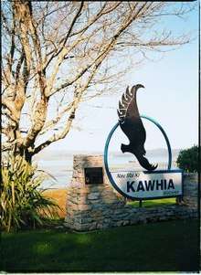
Kawhia Harbour
| Kawhia | |
|---|---|
 Kawhia | |
| Coordinates: 38°6′S 174°48′E / 38.100°S 174.800°ECoordinates: 38°6′S 174°48′E / 38.100°S 174.800°E | |
| Country |
|
| Region | King Country |
| Territorial authority | King Country District |
| Ward | Otorohanga |
| Electorate | Waikato |
| Government | |
| • MP | Barbara Kuriger (National) |
| • Mayor | Max Baxter |
| Population | |
| • Urban | 650 |
| Time zone | UTC+12 (NZST) |
| • Summer (DST) | UTC+13 (NZDT) |
| Postcode | 2451 |
| Area code(s) | 07 |
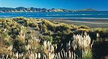
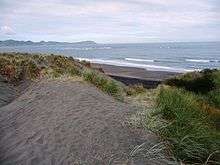
Kawhia Harbour (Maori: "Kāwhia") is one of three large natural inlets in the Tasman Sea coast of the Waikato region of New Zealand's North Island. It is located to the south of Raglan Harbour, Ruapuke and Aotea Harbour, 40 kilometres southwest of Hamilton. Kawhia is part of the Otorohanga District Council.[1] It has a high-tide area of 68 km2 (26 sq mi) and a low-tide area of 18 km2 (6.9 sq mi).[2]
The settlement of Kawhia is located on the northern coast of the inlet, and was an important port in early colonial New Zealand.[3] The area of Kawhia comprises 16 to 20 hectares (40 to 50 acres) and is the town block that was owned by the New Zealand Government. The government bought it from the Europeans in 1880 "not from the original Māori owners, but from the a European who claimed ownership in payment of money owed by another European".[3]
In January 2018, the health board issued a statement that there was no additional risk from tuberculosis in Kawhia after reports of three possible cases.[4][5]
History
The harbour area was the birthplace of prominent Māori warrior chief Te Rauparaha of the Ngāti Toa tribe, who lived in the area until the 1820s, when he, and his tribe along with Ngāti Rārua and Ngāti Koata migrated southwards.
Kawhia is known in Māori lore as the final resting-place of the ancestral waka (canoe) Tainui. Soon after arrival, captain Hoturoa made it first priority to establish a whare wananga (sacred school of learning) which was named Ahurei.[6] Ahurei is situated at the summit of the sacred hill behind Kawhia’s seaside marae – Maketu Marae.
Tainui was buried at the base of Ahurei by Hoturoa himself, and other members of the iwi. Hoturoa marked out the waka with two limestone pillars which he blessed. Firstly, there is "Hani (Hani-a-te-waewae-i-kimi-atu) which is on the higher ground and marked the prow of the canoe".[7] Marking the stern of the canoe, Hoturoa placed the symbol of Puna, the spirit-goddess of that creation story. "In full it is named Puna-whakatupu-tangata, and represents female fertility, the spring or source of humanity".[6] It is said that a pure woman who touches this stone will be given the gift of a child, and become pregnant. There have been cases of women using Puna when they have had difficulty conceiving a child.
Ahurei overlooks Kawhia Harbour and Maketu Marae. The main meeting house, Auaukiterangi, is named after Hoturoa’s father who was a high chief (ariki) and was built and opened in 1962. The eldest and most prestigious meeting house that was first built on Maketu Marae is Te Ruruhi (the Old Lady) which was used as the dining hall until the erection of Te Tini O Tainui. This two-storied dining hall was built in 1986 in order to cater for the numerous numbers that visit for occasions such as annual poukai, tangi and hui.[8]
Te Puia Hot Springs
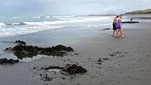
2 hours either side of low tide (for tide times see tide-forecast.com)[9] about 100m of the Tasman Sea beach, 4 km from Kawhia (see 1:50,000 map[10]), oozes hot water, which can be formed into shallow bathing pools with a spade.[11]
A council sample taken on 30 March 2006 showed a temperature of 45.4 °C (58 °C has also been measured)[12] and listed these in the water.[13]
| Site | pH | Li | Na | K | Ca | Mg | Rb | Cl | SO4 | B | SiO2 | NH4 | HCO3 | S Total | F | Fe | 18OVSMOW | d2HVSMOW | Br |
|---|---|---|---|---|---|---|---|---|---|---|---|---|---|---|---|---|---|---|---|
| Te Puia | 7.9 | 9.21.71 | 3870 | 121 | 2150 | 107 | 0.094 | 9540 | 724 | 7.5 | 34.3 | 2.17 | 25 | 0.712 | 0.62 | 0.1 | -2.66 | -21.7 | 29.6 |
Notable people
- John Kent, European trader, 1820s–1830s
- Cort and Annie Jane Schnackenberg, 1860s missionaries[14]
- Carole Shepheard (born 1945), artist
References
- ↑ "2006 Census data".
- ↑ "Mapping residence times in west coast estuaries of the Waikato region". Waikato Regional Council. Retrieved 2017-12-14.
- 1 2 "Kawhia Harbour History". Retrieved 18 April 2016.
- ↑ "No risk of Tuberculosis in Kawhia community | Waikato Newsroom". waikatodhbnewsroom.co.nz. Retrieved 2018-03-15.
- ↑ "Five confirmed cases of tuberculosis from Kawhia". Stuff. Retrieved 2018-01-21.
- 1 2 "Kawhia Maori History". www.kawhia.maori.nz.
- ↑ Kawhia Harbour, para 15-16
- ↑ http://www.waitomo.org.nz/waitomo-region-facts.asp
- ↑ "Tide Times and Tide Chart for Kawhia". www.tide-forecast.com.
- ↑ "NZTOPOMAPS.COM - New Zealand Topographic Map online". www.nztopomaps.com.
- ↑ http://www.nzhotpools.co.nz/hot-pools/kawhia-springs-te-puia-springs
- ↑ "Page not found – NZ Geothermal Association" (PDF).
- ↑ http://www.waikatoregion.govt.nz/PageFiles/5440/tr0801.pdf
- ↑ Hutching, Megan. "Annie Jane Schnackenberg". Dictionary of New Zealand Biography. Ministry for Culture and Heritage. Retrieved 16 March 2012.