Ōmachi, Nagano
| Ōmachi 大町市 | |||
|---|---|---|---|
| City | |||
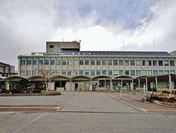 Ōmachi City Hall | |||
| |||
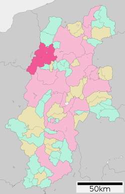 Location of Ōmachi in Nagano Prefecture | |||
 Ōmachi | |||
| Coordinates: 36°30′10.8″N 137°51′4″E / 36.503000°N 137.85111°ECoordinates: 36°30′10.8″N 137°51′4″E / 36.503000°N 137.85111°E | |||
| Country | Japan | ||
| Region | Chūbu (Kōshin'etsu) | ||
| Prefecture | Nagano | ||
| Area | |||
| • Total | 565.15 km2 (218.21 sq mi) | ||
| Population (October 2016) | |||
| • Total | 27,587 | ||
| • Density | 48.8/km2 (126/sq mi) | ||
| Time zone | UTC+9 (Japan Standard Time) | ||
| Symbols | |||
| • Tree | Prunus sargentii | ||
| • Flower | Erythronium japonicum | ||
| • Bird | Rock ptarmigan | ||
| • Animal | Japanese Serow | ||
| Phone number | 0261-22-0420 | ||
| Address | 3887, Ōmachi, Ōmachi-shi, Nagano-ken 398-0002 | ||
| Website | http://www.city.omachi.nagano.jp/ | ||


Ōmachi (大町市 Ōmachi-shi) is a city located in Nagano Prefecture, Japan. As of 1 October 2016, the city had an estimated population of 27,587, and a population density of 48.8 persons per km². Its total area is 565.15 square kilometres (218.21 sq mi).
Geography
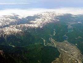
Ōmachi is located west of Nagano, the capital of Nagano Prefecture, in the Daihoku District (大北地域 Daihoku-chiiki) of the prefecture. The 3000 meter Northern Japanese Alps (or Hida Mountains) are to the west ranges to the west of the city and mountains of around 1000 meters form the eastern border. The Takase River runs through the city, which is located in the northern Matsumoto basin.
The Itoigawa-Shizuoka Tectonic Line active fault system is also running through the city.
- Mountains: Mount Yarigatake, Mount Noguchigorō (野口五郎岳 Noguchigorō-dake), Mount Eboshi (烏帽子岳 Eboshi-dake), Mount Sugoroku (双六岳 Sugoroku-dake), Mount Otenshō (大天井岳 Otenshō-dake), Mount Tsubakuro (燕岳 Tsubakuro-dake), Mount Gaki (餓鬼岳 Gaki-dake), Mount Harinoki (針ノ木岳 Harinoki-dake), Mount Renge (蓮華岳 Renge-dake), Mount Jii (爺ヶ岳 Jii-ga-take), Mount Kashimayari (鹿島槍ヶ岳 Kashimayari-ga-take), Mount Goryū (五竜岳 Goryū-dake)
- Rivers: Takase River
- Lakes and marshes: Nishina three lakes (仁科三湖 Nishina-san-ko) (Lake Kizaki (木崎湖 Kizaki-ko), Lake Nakatsuna (中綱湖 Nakatsuna-ko), Lake Aoki (青木湖 Aoki-ko))
Surrounding municipalities
Climate
Due to its elevation, Omachi has a humid continental climate (Köppen Dfa). Winters are cold and very snowy, while summers are very warm and wet.
| Climate data for Omachi, Nagano (1981–2010) | |||||||||||||
|---|---|---|---|---|---|---|---|---|---|---|---|---|---|
| Month | Jan | Feb | Mar | Apr | May | Jun | Jul | Aug | Sep | Oct | Nov | Dec | Year |
| Average high °C (°F) | 1.4 (34.5) |
2.3 (36.1) |
6.7 (44.1) |
14.9 (58.8) |
20.3 (68.5) |
23.3 (73.9) |
26.6 (79.9) |
28.2 (82.8) |
23.2 (73.8) |
17.3 (63.1) |
11.3 (52.3) |
4.9 (40.8) |
15.1 (59.2) |
| Daily mean °C (°F) | −2.9 (26.8) |
−2.5 (27.5) |
1.1 (34) |
8.0 (46.4) |
13.6 (56.5) |
17.6 (63.7) |
21.1 (70) |
22.2 (72) |
17.9 (64.2) |
11.3 (52.3) |
5.4 (41.7) |
0.1 (32.2) |
9.4 (48.9) |
| Average low °C (°F) | −7.6 (18.3) |
−7.5 (18.5) |
−3.9 (25) |
1.9 (35.4) |
7.8 (46) |
12.9 (55.2) |
17.0 (62.6) |
17.8 (64) |
13.7 (56.7) |
6.6 (43.9) |
0.6 (33.1) |
−4.3 (24.3) |
4.6 (40.3) |
| Average precipitation mm (inches) | 80.3 (3.161) |
81.6 (3.213) |
98.5 (3.878) |
95.3 (3.752) |
121.2 (4.772) |
165.5 (6.516) |
195.8 (7.709) |
134.2 (5.283) |
168.4 (6.63) |
109.8 (4.323) |
76.4 (3.008) |
70.3 (2.768) |
1,397.1 (55.004) |
| Average snowfall cm (inches) | 180 (70.9) |
147 (57.9) |
91 (35.8) |
8 (3.1) |
0 (0) |
0 (0) |
0 (0) |
0 (0) |
0 (0) |
1 (0.4) |
9 (3.5) |
89 (35) |
525 (206.6) |
| Source: Japan Meteorological Agency[1] | |||||||||||||
History
The area of present-day Ōmachi was part of ancient Shinano Province. The area was part of the holdings of Matsumoto Domain during the Edo period. The modern town of Ōmachi was established with the creation of the municipalities system on April 1, 1889. It merged with the neighboring villages of Taira, Tokiwa and Yashiro on July 1, 1954 to form the city of Ōmachi. On January 1, 2006, the villages of Miasa and Yasaka (both from Kitaazumi District) were merged into Ōmachi.
Education
Ōmachi has five public elementary schools, three public middle schools and one combined elementary/middle school operated by the city government. There are two public high schools operated by the Nagano Prefectural Board of Education.
Transportation
Railway
Highway
International relations


Local attractions
References
- ↑ "平年値(年・月ごとの値)". Japan Meteorological Agency.
External links
| Wikimedia Commons has media related to Ōmachi, Nagano. |
- Official Website (in Japanese)
- Ōmachi City Tourism Website (in Japanese)
| Core city | |
|---|---|
| Special city | |
| Cities | |
| Districts | |