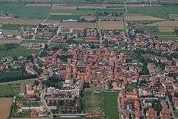
Misano di Gera d'Adda
| Misano di Gera d'Adda | |
|---|---|
| Comune | |
| Comune di Misano di Gera d'Adda | |
 Misano di Gera d'Adda | |
 Misano di Gera d'Adda Location of Misano di Gera d'Adda in Italy | |
| Coordinates: 45°28′N 9°37′E / 45.467°N 9.617°ECoordinates: 45°28′N 9°37′E / 45.467°N 9.617°E | |
| Country | Italy |
| Region | Lombardy |
| Province | Province of Bergamo (BG) |
| Area | |
| • Total | 6.1 km2 (2.4 sq mi) |
| Elevation | 104 m (341 ft) |
| Population (Dec. 2004) | |
| • Total | 2,877 |
| • Density | 470/km2 (1,200/sq mi) |
| Demonym(s) | Misanesi |
| Time zone | UTC+1 (CET) |
| • Summer (DST) | UTC+2 (CEST) |
| Postal code | 24040 |
| Dialing code | 0363 |
Misano di Gera d'Adda (Bergamasque: Misà) is a comune (municipality) in the Province of Bergamo in the Italian region of Lombardy, located about 35 kilometres (22 mi) east of Milan and about 25 kilometres (16 mi) south of Bergamo. As of 31 December 2004, it had a population of 2,877 and an area of 6.1 square kilometres (2.4 sq mi).[1]
Misano di Gera d'Adda borders the following municipalities: Calvenzano, Capralba, Caravaggio, Vailate.
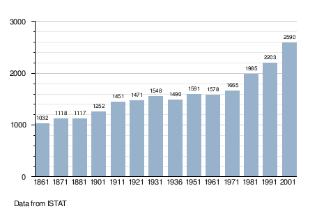
Demographic evolution
References

This article is issued from
Wikipedia.
The text is licensed under Creative Commons - Attribution - Sharealike.
Additional terms may apply for the media files.