Costa Volpino
| Costa Volpino | ||
|---|---|---|
| Comune | ||
| Comune di Costa Volpino | ||
 Costa Volpino | ||
| ||
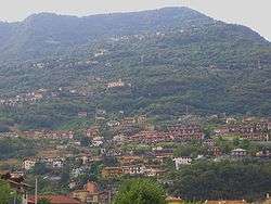
 Costa Volpino Location of Costa Volpino in Italy | ||
| Coordinates: 45°49′50″N 10°05′57″E / 45.83056°N 10.09917°ECoordinates: 45°49′50″N 10°05′57″E / 45.83056°N 10.09917°E[1] | ||
| Country | Italy | |
| Region | Lombardy | |
| Province | Bergamo (BG) | |
| Frazioni | Branìco, Ceratéllo, Corti, Flaccanìco, Qualìno, Piano, Volpino | |
| Government | ||
| • Mayor | Mauro Bonomelli | |
| Area | ||
| • Total | 18 km2 (7 sq mi) | |
| Elevation | 192 m (630 ft) | |
| Population (31 December 2011)[2] | ||
| • Total | 9,399 | |
| • Density | 520/km2 (1,400/sq mi) | |
| Demonym(s) | Costavolpinesi | |
| Time zone | UTC+1 (CET) | |
| • Summer (DST) | UTC+2 (CEST) | |
| Postal code | 24062 | |
| Dialing code | 035 | |
| Website | Official website | |
Costa Volpino (Bergamasque: Cósta Ulpì) is a comune in the province of Bergamo, in Lombardy, Italy. Situated at the end of Valle Camonica, where the Oglio river enters the Lake Iseo, it is bounded by other communes of Lovere and Rogno.
References
- ↑ "The World Gazetteer". Archived from the original on 2007-10-01. Retrieved 2007-02-23.
- ↑ ISTAT Archived March 3, 2016, at the Wayback Machine.
| Wikimedia Commons has media related to Costa Volpino. |
.jpg)
| Location | ||
|---|---|---|
| Settlements | ||
| Islands | ||
| Rivers |
| |
| Valleys | ||

This article is issued from
Wikipedia.
The text is licensed under Creative Commons - Attribution - Sharealike.
Additional terms may apply for the media files.