Vailate
| Vailate Aliàt (Lombard) | |
|---|---|
| Comune | |
| Comune di Vailate | |
 Vailate Location of Vailate in Italy | |
| Coordinates: 45°28′N 9°36′E / 45.467°N 9.600°ECoordinates: 45°28′N 9°36′E / 45.467°N 9.600°E | |
| Country | Italy |
| Region | Lombardy |
| Province | Province of Cremona (CR) |
| Area | |
| • Total | 9.8 km2 (3.8 sq mi) |
| Population (Dec. 2004) | |
| • Total | 4,299 |
| • Density | 440/km2 (1,100/sq mi) |
| Time zone | UTC+1 (CET) |
| • Summer (DST) | UTC+2 (CEST) |
| Postal code | 26019 |
| Dialing code | +390363 |
| Website | Official website |
Vailate (Cremasco: Aliàt) is a comune (municipality) in the Province of Cremona in the Italian region Lombardy, located about 35 kilometres (22 mi) east of Milan and about 50 kilometres (31 mi) northwest of Cremona. As of 31 December 2004, it had a population of 4,299 and an area of 9.8 square kilometres (3.8 sq mi).[1]
Vailate borders the following municipalities: Agnadello, Arzago d'Adda, Calvenzano, Capralba, Misano di Gera d'Adda, Torlino Vimercati.
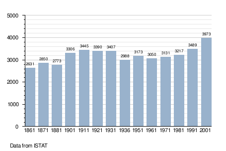
Demographic evolution
References
External links

This article is issued from
Wikipedia.
The text is licensed under Creative Commons - Attribution - Sharealike.
Additional terms may apply for the media files.