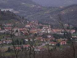
Cenate Sopra
| Cenate Sopra | |
|---|---|
| Comune | |
| Comune di Cenate Sopra | |
 Cenate Sopra | |
 Cenate Sopra Location of Cenate Sopra in Italy | |
| Coordinates: 45°43′N 9°49′E / 45.717°N 9.817°ECoordinates: 45°43′N 9°49′E / 45.717°N 9.817°E | |
| Country | Italy |
| Region | Lombardy |
| Province | Province of Bergamo (BG) |
| Frazioni | Sant'Ambrogio, Valpredina, Piazze |
| Area | |
| • Total | 6.9 km2 (2.7 sq mi) |
| Elevation | 330 m (1,080 ft) |
| Population (Dec. 2004) | |
| • Total | 2,248 |
| • Density | 330/km2 (840/sq mi) |
| Demonym(s) | Sanleonesi |
| Time zone | UTC+1 (CET) |
| • Summer (DST) | UTC+2 (CEST) |
| Postal code | 24069 |
| Dialing code | 035 |
Cenate Sopra (Bergamasque: Senàt Sura) is a comune (municipality) in the Province of Bergamo in the Italian region of Lombardy, located about 60 kilometres (37 mi) northeast of Milan and about 12 kilometres (7.5 mi) east of Bergamo. As of 31 December 2004, it had a population of 2,248 and an area of 6.9 square kilometres (2.7 sq mi).[1]
The municipality of Cenate Sopra contains the frazioni (subdivisions, mainly villages and hamlets) Sant'Ambrogio, Valpredina, and Piazze.
Cenate Sopra borders the following municipalities: Albino, Cenate Sotto, Pradalunga, Scanzorosciate, Trescore Balneario.
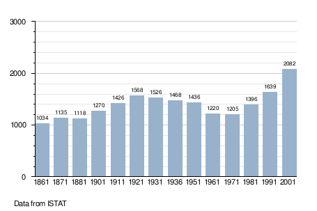
Demographic evolution
References

| Authority control |
|---|
This article is issued from
Wikipedia.
The text is licensed under Creative Commons - Attribution - Sharealike.
Additional terms may apply for the media files.