Telgate
| Telgate | |
|---|---|
| Comune | |
| Comune di Telgate | |
 | |
 Telgate Location of Telgate in Italy | |
| Coordinates: 45°38′N 9°51′E / 45.633°N 9.850°ECoordinates: 45°38′N 9°51′E / 45.633°N 9.850°E | |
| Country | Italy |
| Region | Lombardy |
| Province | Province of Bergamo (BG) |
| Area | |
| • Total | 8.1 km2 (3.1 sq mi) |
| Elevation | 191 m (627 ft) |
| Population (Dec. 2004) | |
| • Total | 4,598 |
| • Density | 570/km2 (1,500/sq mi) |
| Demonym(s) | Telgatesi |
| Time zone | UTC+1 (CET) |
| • Summer (DST) | UTC+2 (CEST) |
| Postal code | 24060 |
| Dialing code | 035 |
| Website | Official website |
Telgate (Bergamasque: Telgàt) is a comune (municipality) in the Province of Bergamo in the Italian region of Lombardy, located about 60 kilometres (37 mi) northeast of Milan and about 15 kilometres (9 mi) southeast of Bergamo. As of 31 December 2004, it had a population of 4,598 and an area of 8.1 square kilometres (3.1 sq mi).[1]
Telgate borders the following municipalities: Bolgare, Chiuduno, Grumello del Monte, Palazzolo sull'Oglio, Palosco.
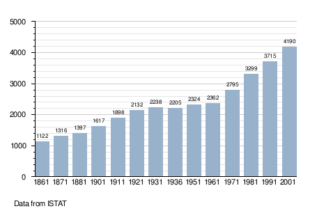
Demographic evolution
Twin towns — sister cities
Telgate is twinned with:

References
External links

| Authority control |
|---|
This article is issued from
Wikipedia.
The text is licensed under Creative Commons - Attribution - Sharealike.
Additional terms may apply for the media files.